YOUR NEXT TRAVEL EXPERIENCE
Search Results
274 results found with an empty search
- BE ALERT IN UNRULY OUTBACK TOWNS
HALLS CREEK & FITZROY CROSSING Not all places extend the warmest of welcomes to travellers and out-of-towners. In fact, a certain minority of small-town populations, both indigenous and non-indigenous harbor negative sentiments towards those who do not belong to their community. This phenomenon can often be attributed to various underlying factors that shape the attitudes of locals. For instance, feelings of being overlooked or forgotten by the outside world can lead to a defensive posture against outsiders. In many cases, these towns face limited opportunities for self-advancement, which can foster resentment towards those who are perceived as intruding on their way of life or exploiting their resources. Additionally, there may be a sense of perceived injustice, where locals feel that their needs and concerns are not adequately addressed, further intensifying their hostility. The Reputation of Certain Outback Towns As a result of these sentiments, some outback towns develop a poor reputation, often unjustly so, but nonetheless powerful in its effects. It is interesting to note that these two towns, that are known for their sometimes unwelcoming nature from a small minority, are situated just a few hours apart by car. These towns are situated along the only sealed road leading west and east in Northern, Western Australia, making them unavoidable stops for any traveller attempting to traverse the region. This geographical reality places visitors in a precarious position, as they must navigate through areas known for their perceived negative atmosphere. Challenges Faced by Travellers Reports indicate that vehicle vandalism is alarmingly prevalent in these towns, and unruly behaviour among certain segments of the population is not uncommon. Such circumstances create an environment where it is advisable for travellers to avoid stopping altogether, opting instead to drive straight through these outback towns without pausing for any reason. Unfortunately, the vast distances in this remote region necessitate refuelling, which complicates the situation further. When planning a journey through these areas, it is crucial for travellers to remain vigilant and take necessary precautions. Keeping all belongings securely locked within the vehicle is essential, as is minimizing the time spent at fuel stations. The goal is to refuel swiftly and continue on the journey without drawing unnecessary attention or exposing oneself to potential risks. Having said that, all interactions with local workers are pleasant enough and no doubt these workers do good in the community. The Role of Exaggeration in Travel Narratives At no time was hostility observed directly. Of course, it is important to recognise stories about these towns can often be exaggerated or sensationalised. Many stories have lingered on from yesteryear and are not valid criticisms anymore. While there may be a kernel of truth in the accounts of vandalism and hostility, the reality is often more nuanced than the tales suggest. However, in the vast and isolated stretches of Northern, Western Australia, where help can be far away, it is prudent to err on the side of caution. The potential risks associated with stopping in these towns, even if they are based on exaggerated narratives, are not worth taking when one is in the middle of nowhere with limited options for support. In conclusion, while the negative reputation of certain small towns may be rooted in a complex interplay of local sentiments and external perceptions, the practical implications for travellers are clear. It is wise to remain aware of the environment, take appropriate precautions, and prioritise safety over convenience when navigating through these less welcoming areas. On arrival in these small towns the first negative perception one first gets does not do them any favours, making one think there's some truth to the stories. Traveldriven DRIVE - HALLS CREEK - FITZROY CROSSING THE ARMY IN TOWN OVERNIGHT AT FITZROY CROSSING FITZROY RIVER LODGE & CAMPING REST STOP AFTER HALLS CREEK UNDER THE SHADE OF THE BOAB TREE HALLS CREEK PROBLEMS HALLS CREEK NORTHERN WESTERN AUSTRALIA PREV AUSTRALIA 2025 NEXT
- UNWIND & RELAX IN BROOME 2025
ADJUST TO BROOME TIME Almost 15,000 people call the coastal town of Broome home, nestled in the stunning landscape of Western Australia. This vibrant community thrives in a region known for its rich cultural heritage and breathtaking natural beauty. During the warm winter months, the population swells significantly, often exceeding 30,000 as tourists flock to the area to escape colder climates. The influx of visitors transforms Broome into a bustling hub of activity, making it a lively and dynamic place to be. Broome is not only busy in terms of its population; it also boasts a large geographic area. The town's layout is expansive, which allows for a variety of attractions and amenities spread throughout. Interestingly, despite its size and the volume of traffic that flows through, there are no traffic lights in the town. This unique characteristic adds to the charm of Broome, but it can also present challenges for residents and visitors alike, particularly when it comes to navigating busy roundabouts and finding suitable parking spaces. At peak times, such as during the tourist season, securing a parking spot can become quite a task, requiring patience and a bit of local knowledge. STAY IN TOWN & BUY PEARLS Accommodations in Broome are plentiful, catering to a wide range of preferences and budgets. From luxurious resorts to cozy guesthouses and backpacker hostels, there is something for everyone. However, it is important to note that during the winter months, many of these establishments fill to capacity quickly due to the high demand from tourists. Advanced bookings are often recommended to avoid disappointment, as visitors seek to experience the unique offerings of this coastal paradise. The town is also home to a diverse array of cafes, shops and local brewers such as Spinifex and Mateso. Many of which are tailored to the tourist market offering a dining out experience. Among these businesses, pearl retailers stand out, showcasing the region's famous cultured pearls that have made Broome renowned in the jewellery world. These shops not only offer exquisite pieces but also provide insights into the pearling industry that has been a significant part of Broome's history. CABLE BEACH One of the must-visit attractions in Broome is the iconic Cable Beach, known for its stunning views and pristine sands. This beach is a magnet for both locals and tourists, especially during the sunset hours. Visitors flock to the large food outlets located just back from the foreshore, where they can enjoy delicious meals while soaking in the breathtaking scenery. Dining al fresco, patrons are treated to a spectacular display of colors as the sun sets over the Indian Ocean, painting the sky in vibrant shades of orange and red. This daily spectacle draws large crowds, creating a lively atmosphere that encapsulates the essence of Broome's coastal lifestyle. Broome is a town thriving on its unique blend of local culture, natural beauty, and tourism, making it a fascinating place to live and visit. Whether you are a resident enjoying the laid-back lifestyle or a tourist exploring the myriad attractions, Broome offers a rich experience that is hard to forget. Traveldriven BROOME GOOGLE MAPS TOWN JETTY PIONEERS TOWN JETTY LOW TIDE & TWO BEACHCOMBERS CENTRE & RIGHT OF PHOTO TOWN JETTY AT ALMOST HIGH TIDE WELL ABOVE LOW TIDE HEAD HEIGHT TOWN BEACH CABLE BEACH VOLLEYBALL $100,000 PEARL PEARL DIVER STREETERS JETTY MATSOS GINGER BEER SPINIFEX OUTDOOR ENTERTAINMENT AREA BROOME ART SQUID ON THE MENU, MANGROVE HOTEL PREV AUSTRALIA 2025 NEXT
- VIEW PINK LAKE & WILDFLOWER COUNTRY AT MORAWA
PORT GREGORY On the drive to or from the town of Kalbarri along the Coral Coast Highway route, travellers may find themselves passing through the fishing village of Port Gregory. This small yet captivating town is renowned for its most striking feature: a breathtaking lagoon that boasts an extraordinary bubble-gum pink hue. This vibrant body of water is affectionately known as Hutt Lagoon, and its vivid color is a result of the presence of specific types of algae, particularly Dunaliella salina, which thrive in the saline conditions of the lagoon. As visitors approach Port Gregory, they will find that a well-maintained sealed road runs parallel to the lagoon, providing easy access for those who wish to stop and take in the surreal beauty of the scene. The bright pink water against the clear blue sky creates a stunning visual contrast that is irresistible to photographers and nature enthusiasts alike. Tourists frequently pull over to capture the unique colors and the serene landscape, making it a popular spot for memorable photographs that showcase the natural beauty of Western Australia. MORAWA This small inland wildflower capital is situated approximately 350 kilometres north of Perth, nestled within the expansive and picturesque Western Australian wheatbelt region. This area is renowned for its unique and diverse flora, which flourishes in the warm, temperate climate characteristic of the region. During the spring months, typically from August to October, the landscape transforms into a vibrant tapestry of colors, drawing visitors who are eager to witness the breathtaking spectacle of wildflowers in full bloom. Among the myriads of wildflower species gracing this region, one can find exquisite orchids, which are celebrated for their intricate and varied forms. These delicate flowers often thrive in the most unexpected places, showcasing a remarkable resilience to the local climate. Another notable species is the foxglove, recognised for its striking bell-shaped blossoms that dangle gracefully from slender stems, creating a whimsical atmosphere in the bushland. In addition to these, the grevillea, with its unique and often spiky flowers, attracts a variety of pollinators, including bees and birds, contributing to the rich biodiversity of the area. Acacias, and wattles, are also prominent, displaying their fluffy yellow blooms adding a cheerful brightness to the landscape. Throughout the bushland the ground is often carpeted with everlasting daisies, which are known for their vibrant hues. These resilient flowers are a favourite among visitors, as they symbolise the enduring spirit of the wildflower season. The sight of these daisies, along with other wildflowers, creates a stunning visual feast that captivates the hearts of nature enthusiasts and casual observers alike. The combination of colors, scents, and textures makes this region a true paradise for those who appreciate the beauty of the natural world. Moreover, the local community embraces this floral bounty, often hosting festivals and events celebrating the wildflower season. Traveldriven MORAWA GOOGLE MAPS DRIVE KALBARRI - PORT GREGORY - MORAWA ON THE ROAD TO PORT GREGORY VIBRANT PINK LAKE MORAWA IS WILDFLOWER COUNTRY MORAWA SHOP FRONT MORAWA WALK THE MAIN STREET WILDFLOWERS OF MORAWA OUTBACK NOTICE MORAWA SHOP FRONT PREV AUSTRALIA 2025 NEXT
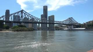
- BRISBANE RIVER CRUISE, NOOSA HEADS & HOME ROAD TRIP AUSTRALIA
Pacific Highway On this road trip I did not follow the Pacific Highway. The highway is almost 800 km long and runs between Brisbane and Sydney following at times a somewhat twisty coastal route. Brisbane Road Trip Australia If in Brisbane it is a little over a one-hour drive to the Gold Coast and one and a half hours to the Sunshine Coast. Both are tourist hot spots with numerous popular surf beaches. Southbank is a popular recreational area in Brisbane. Southbank is on the southern bank of the Brisbane River and easily walked from Brisbane CBD. I prearranged Brisbane accommodation in Spring Hill, near the CBD. Time spent in Brisbane was two nights and one full day. Breakfast Creek Hotel for Lunch I joined a Southbank Brisbane River tour with River City Cruises to the famous Breakfast Creek Hotel for a mighty steak lunch. A one-and-a-half-hour tour aboard MV Neptune. An excellent relaxed way to take in the city sights. Complimentary Morning tea and a beverage on the return trip. $60 including a lunch voucher. The tour included very informative commentary. The Breakfast Creek Hotel is probably the most famous hotel in Queensland. Rivalling the Birdsville Hotel. Has weathered many floods. A cold beer and a meal is available in the quiet oak timbered historic bar. Away from the large modern bistro area catering to most visiting patrons. NOOSA HEADS is about one hundred and forty kilometres (85 mi) north of Brisbane. Noosa Heads is the tourist heart of Noosa district, with many restaurants and hotels. The main retail street is Hastings Street, which lies directly behind the seashore. Along Hastings Street it's difficult to get parking. Noosa is the land of roundabouts and suburbs. The Noosa Heads Yacht Club offers a bistro-style restaurant and bar overlooking the Noosa River and is ten minutes drive from Hastings Street. The Yacht Club is good for a lunch or dinner alongside the Noosa River. I decided not to continue down the NSW east coast and Pacific Highway as I have travelled the coastal highway a few times before. Through Pacific Highway coastal regional cities such as: Byron Bay Memories of surf lifesaving carnival's causing many of the town streets to be blocked off by local council. The streets that could be driven were extremely busy to navigate. The city is home to a few famous people tucked away in their coastal retreats. Coffs Harbour and the thirteen metre Big Banana. Now features a large fun park and water park. The first of the big things in Australia. Built 1964. Port Macquarie with its low high rise looking over the pristine marina and its boats and the ideal climate. Perhaps enjoying the best year round weather in Australia. Newcastle and it's ocean baths. Nobbys Head views surrounded by water on three sides. Memories are of hiring and driving sand buggies in, around and over sand dunes with fighter jets screaming overhead out of Williamstown Air Force Base. On this road trip the return drive was via the inland Brisbane expressway to Toowoomba and overnight rest, then onto Goondiwindi on the Queensland border and into Victoria. Ending the three week solo Australia road trip, Victoria to Townsville in Queensland and return. Traveldriven CURRENT BRISBANE FIVE DAY FORECAST BRISBANE GOOGLE MAPS RIVER CITY CRUISES NOOSA HEADS GOOGLE MAPS BRISBANE RIVER CRUISE BRISBANE RIVER & BIG WILLIE SKYSCRAPER BRISBANE CITY STREET LINED WITH PALMS BREAKFAST CREEK HOTEL, BRISBANE BREAKFAST CREEK HOTEL WRITING ON THE WALL THE BREKKY CREEK GANG SIGN BRISBANE RIVER TOUR TO THE BREKKY CREEK PUB BRISBANE WELCOME SIGN SOUTHBANK BRISBANE MALL ENTERTAINER BRISBANE CBD PREV ROADTRIP TOWNSVILLE NEXT PREV QUEENSLAND NEXT HOMEPAGE
- TOSS A COIN TO THE DOG ON THE TUCKERBOX
Hume Freeway & the Dog on The Tuckerbox The Hume Freeway runs the entire inland route from Melbourne in Victoria to Sydney in New South Wales. There are a number of roadside attractions worthy of a stop and a rest break along the freeway. One such attraction is the famous Dog on The Tuckerbox. To view the Dog on The Tuckerbox is free to all those who pass by. The Dog Located at Snake Gully. The dog is a very famous Australian historical monument and tourist attraction. Five miles (eight kilometres) from Gundagai, New South Wales. A gift shop is on site for Australian souvenirs. The dog statue, perched atop a raised monument, exudes a sense of reverence as it overlooks the tranquil surroundings. Encircled by a shallow pool of glistening water, the statue stands as a symbol of loyalty and companionship. The pool, often adorned with a sprinkling of coins shimmering at its bottom, bears witness to the heartfelt gestures of visitors. Like a ritualistic tradition, tourists partake in the age-old custom of tossing coins into the pool, reminiscent of the whimsical practice observed at wishing wells. Each coin cast into the water carries with it a silent wish, a fleeting hope, or a heartfelt prayer, creating a tapestry of dreams interwoven with the statue's enduring presence. The harmonious blend of tradition, belief, and artistry transforms this serene spot into a sanctuary where the past and present converge in a timeless dance of reverence and wonder. The wayside stop is a location on the Hume Freeway for electric vehicle charging stations. A sign of the changing or should say, charging times. The Dog and the Tuckerbox Tuckerbox is an old word meaning the same as lunchbox. The dog is actually a mongrel dog similar to working dogs the drover's used. A mundane story for a poem but written in such a way as to capture a growing national Australian identity Australians could relate to when it was published in 1857. Conveyed a sentiment of looking out for your mate's wellbeing regardless of class or station in life. A notion Australian's have always liked and stood up for. The iconic Australian statue, Dog on the Tuckerbox, holds a significant place in the country's cultural heritage. This beloved sculpture is inspired by the famous poem "Bullocky Bill" penned by the talented poet Bowyang Yorke. The poem itself is a poignant and humorous narrative that captures the essence of outback life in Australia during the early pioneering days. It tells the tale of a resilient bullock driver named Bill and his faithful canine companion who guard a tuckerbox, symbolising their unwavering determination and loyalty in the face of adversity. Tuckerbox Statue The Dog on the Tuckerbox statue, which is located near Gundagai, New South Wales, serves as a tribute to the enduring spirit of the Australian bushmen and their enduring bond with their loyal four-legged friends. This statue has become a popular tourist attraction and a symbol of national pride, drawing visitors from near and far to admire its craftsmanship and pay homage to the enduring legacy of Bowyang Yorke's evocative poem. The imagery of the dog sitting stoically on the tuckerbox has become ingrained in the collective consciousness of Australians, symbolising qualities such as loyalty, companionship, and resilience. It stands as a reminder of the hardships faced by early settlers and the importance of camaraderie in overcoming challenges. The Dog on the Tuckerbox continues to evoke a sense of nostalgia and admiration for the pioneers who shaped Australia's rich history, making it a cherished symbol of the country's cultural identity. Traveldriven GUNDAGAI GOOGLE MAPS Drive Albury to the Dog on the Tucker Box THE DOG ON THE TUCKERBOX and GIFT SHOP IN BACKGROUND THE DOG ON THE TUCKERBOX MONUMENT LAZY HARRY Road To Gundagai is a folk song by Banjo Paterson MUSTANG ROADTRIP TESLA CHARGING STATIONS BEHIND THE DOG ON THE TUCKERBOX THE BIG KOALA NEXT TO THE DOG ON THE TUCKERBOX PREV NSW NEXT PREV CANBERRA ROADTRIP NEXT HOMEPAGE
- MOUNT PANORAMA RACETRACK NIGHT DRIVE MUSTANG GT
NIGHT RACETRACK DRIVE Bathurst is two hundred km northwest of Sydney. Location of the famous Mount Panorama Motor Racing Circuit. Bathurst city hosts the Bathurst 1000 each October. The track is 6.213 km (3.861 mi) in length. Also hosts the Bathurst 12 Hour each February. The Bathurst Motor Festival every Easter. Convenient accommodation may be available in Rydges Motel, Mount Panorama beside the track. There are numerous residences and businesses adjoining the track. These may have no road access on race days. MUSTANG GT NIGHT TRACK DRIVING I did a few laps of the circuit after dark. First lap was clockwise. The opposite direction to normal race events. Very different. Not bothered with speeding over the posted limit of sixty km or following racing lines. Drive up Conrod Straight and turn right at Forrest's Elbow. A sharp turn and a very steep bend and twisty road to Skyline. Very dark. No track side lights. Very dark and enclosed feeling even with high beam headlights. Before descending through the cutting the city lights of Bathurst are seen twinkling in the far distance like star light. Not above but below because of the high road elevation. All the roadside verge very dark. Perhaps the roadside barriers preventing a wide spread of light from the headlights? Once on Pit Straight did a U turn and drove a few laps the normal direction. Driving Counter Clockwise Very dark and unsettling experience. Driving onto Conrod Straight coming face on into Forrest's Elbow, dead in front was a large flash of white and red wall barrier then the long straight. All the while knowing Kangaroos can hop across any time. As it is rural Australian countryside. I much preferred the racing direction of driving counter clockwise. This was much more flowing with less of a steep climb up the mountain after Conrod Straight as in a clockwise lap. In the daylight hours I drove many laps of the circuit in the mustang GT 6 speed manual V8. I was twice asked if I could drive other enthusiasts around the track. Sure, why not. Great experience. Traveldriven ENTER CLICK/TAP BATHURST GOOGLE MAPS DRIVING INTO MOUNT PANORAMA DRIVING ALONG PIT STRAIGHT MOUNT PANORAMA MOUNT PANORAMA TRACK NIGHT DRIVE MOUNT PANORAMA TRACK NIGHT CLOCKWISE PREV NSW NEXT HOMEPAGE
- THREE SISTERS IN THE BLUE MOUNTAINS, TRAVEL DOWN UNDER
Under a two hour drive from Sydney. Visit for a weekend. - Traveldriven The Three Sisters These are three spectacular pillars of sandstone rock in the Blue Mountains of New South Wales, Australia. They are located close by to the town of Katoomba. They rise above the Jamison Valley. The three pillars are named Meehni (922 m), Wimlah (918 m), and Gunnedoo (906 m). There are numerous scenic spots where the Blue Mountains look blue across the valley, and they are less than a two-hour drive from Sydney. Travel Down Under Within walking distance, guests can enjoy a delightful culinary experience at the nearby Echo Point Plaza, where they can savor a variety of delicious dishes for lunch and indulge in a freshly brewed cup of coffee. Additionally, visitors can explore the thrilling attractions of the area, such as the Scenic Skyway and Cliffhanger railway, both of which are conveniently located just a short walk away. A fee is charged to ride on either one. Scenic Skyway The Scenic Skyway offers a unique adventure as it takes passengers 720 metres above the breathtaking Jamison Valley, providing unparalleled panoramic views of the surrounding landscape. This fully enclosed gondola cabin ensures a safe and comfortable journey across the valley, allowing travellers to witness the beauty of the area from a bird's eye perspective. With its horizontal trajectory and spacious capacity, the Scenic Skyway promises an unforgettable experience for all who embark on this remarkable ride. Cliffhanger Known as the world's steepest passenger railway, the Cliffhanger Scenic Railway is an adrenaline-pumping attraction that follows a daring 310-metre route along the cliffside. Featuring adjustable seating that can incline up to a thrilling 64 degrees, this railway offers a vertical ascent up the cliff face, providing a heart-pounding experience for adventure enthusiasts. While the Cliffhanger Railway offers a one-of-a-kind journey, it may not be suitable for those who are uncomfortable with heights, as the dramatic incline adds an extra level of excitement to this exhilarating ride. Traveldriven ENTER CLICK/TAP THE THREE SISTERS GOOGLE MAPS DRIVE SYDNEY TO THE THREE SISTERS THREE SISTERS VIEWING PLATFORM THREE SISTERS PREV NSW NEXT PREV AUSTRALIA ICONS NEXT HOMEPAGE
- TALK TO CAPTAIN COOK, SYDNEY TOURIST ATTRACTIONS
SYDNEY LIGHTS Sydney Harbour Tourist Attractions Sydney Harbour is a part of the Port Jackson waterway area. As is Middle Harbour and North Harbour. Lane Cove and Parramatta Rivers, all form the natural harbour waterways of Sydney, New South Wales. The Sydney Opera House and the Sydney Harbour Bridge in Sydney Harbour are together both one of the most known Australian icons. Great tourist harbour views of the bridge are from the Opera House. The bridge is often called the coat hanger in Australian slang. Sydney Tourist Attractions The Opera House is in effect part of Circular Quay where many water ferries are boarded. Take a water taxi from Circular Quay to Luna Park amusements across the harbour or to Darling Harbour tourist attractions. A water taxi is a convenient scenic and a fast ten minute trip on the harbour. Prices may vary so check first. While at Circular Quay a few tourist providers may be seen dressed as Captain Cook. Enticing people with travel plans. It is not uncommon to encounter a handful of enthusiastic individuals who take on the persona of the famous explorer Captain Cook. These providers go to great lengths to capture the essence of this historical figure, donning elaborate costumes complete with white wigs and long coat tails. Their goal is to attract the attention of passersby and engage them in conversations about travel opportunities and exciting adventures. While some may attempt to mimic a British accent to enhance the authenticity of their portrayal, there is no guarantee that every "Captain Cook" you encounter will sound like a true Brit. Nonetheless, these dedicated individuals play a unique role in adding a touch of whimsy and historical charm to the tourist experience, making them a memorable sight for visitors exploring new destinations. Walk the Historic ‘Rocks’ from Circular Quay and grab a coffee next to the Opera House. Climb the Harbour Bridge if heights are no problem. Bookings essential. Traveldriven SYDNEY CURRENT FIVE DAY FORECAST ENTER CLICK/TAP SYDNEY HARBOUR DARLING HARBOUR GOOGLE MAPS TRIBUTE TO BRIDGE WORKERS THE ROCKS, SYDNEY CBD LUNA PARK SYDNEY HARBOUR SYDNEY OPERA HOUSE PREV NSW NEXT PREV AUSTRALIA ICONS NEXT
- ALPINE WAY MOUNTAIN POSTIE RIDERS & NEAR MISS
Alpine Way The Alpine Way mountain road begins from the town of Jindabyne in the Snowy Mountains of New South Wales and travels to the Victorian state border and onto the town of Corryong in Victoria. The Alpine Way is a fully sealed road. Much of the mountainous driving is between Jindabyne via Thredbo to the small town of Khancoban in New South Wales. This section of the road is 110 km in length but will take two hours to drive. The drive from Khancoban to Corryong in Victoria is 27 km and is over rolling hills and farmland. The Alpine Way, although two way and is sealed, is narrow in many areas between Thredbo and Khancoban. In my opinion it's not recommended to tow anything more than a small trailer along this section of road. This section is tight, twisty and meanders up and down with short straights and heavily wooded mountainsides. Outside of the snow season snow chains are not required or needed. There may be the occasional sightseeing snow on the higher shaded slopes in Spring or Autumn. Above the Tom Groggin Campground the road often has a 15 per cent gradient rise or fall and a few 15\25 km hairpin bends are on these sections of the Alpine Way. Mountain Postie Riders Departing from the town of Jindabyne in the mid-morning with a standard road vehicle and no trailer, the short turnoff to Thredbo soon came into view, permitting a five-minute stop in Thredbo. On entry to the resort village a few dozen motorbike riders with their bikes were milling around the roadside 'Welcome to Thredbo' sign. The motorbikes, all that these riders were on, are those as ridden by postal workers in Australia. Their bikes were scattered off and along the roadside. Postie Bike The Honda CT110 is a 105cc Four stroke single. Has drum brakes and a fuel capacity of 5.5L. Rated top speed of 80 km and about 8 horsepower. The bikes are often used by rider groups for charity rides within Australia. Up Over and Down the Alpine Way Expecting a fairly quite scenic mountainous two-hour drive to Khancoban, it was a bit of an unpleasant surprise to share the road with so many motorcycles that are obviously not built for mountainous roads with their riders hellbent on riding to Khancoban and beyond. More riders were arriving by the minute. These same riders were spotted the previous day numbering greater than one hundred at the Banjo Patterson Hotel carpark in Jindabyne. Now at this very time all deciding to ride the same direction as I was driving. Most appeared to be in groups of roughly ten or so allowing for a few km of spacing in-between. No point waiting for all riders to pass which may take hours I continued on the Alpine Way. Within a few km of leaving Thredbo a line of postie bikes formed behind my vehicle. I slowed a little to the left side of the roadway and allowed space for all to overtake. No problem. A short while later another swarm of bikes were behind, and I let them go by. I began ascending a steep bit of twisting road as more riders were approaching from behind. I rounded a tight bend and came across a gaggle of riders trying to climb the steep hillside. Their bikes seemed to be at full throttle hovering around 50 to 55 kmh. Following the group of bikes for a while I then overtook on short straight sections of road where eighty km or more was possible. The road would top out and begin to descend allowing the riders to catchup behind quite close to the rear of the car on the narrow twisting Alpine Road. One or two overtaking. The next section of steep raising road slowed more bikes in front again to a low speed inviting myself to overtake once again. This back and forth carried on for quite awhile. Many of the riders appeared to have a five litre jerry can of petrol strapped behind them on the bikes. Near Miss A few road sections of the Alpine Way are cut through rock out crops allowing high crests to be driven through to the next downhill part of the narrow road. All well and good but with underpowered postie bikes all around front and rear this made for an unsettling experience. The view was one of a rather comical appearance of swarms of postie bikes catching up very close and then falling behind. Same could be said for bikes out in front. Catching up to bikes on the steep inclines for them to only pull away as the road ahead flattens out. In my opinion a dangerous situation could develop. I descended a long section of road with a sharpish right turning bend at the bottom and followed closely by a large group of postie bikes. I looked to my right a postie bike appeared to be a car door length off of the side of the rear passenger door trying to brake for the quickly tightening bend. Turning forward I focused on the road ahead expecting a scrape of metal on the car but heard nothing. I continued driving. Soon another downhill section of road appeared. Again, descending and turning right with postie bikes on my rear bumper I unexpectedly came across a very narrow single lane bridge with a span of fifty metres or so. An approaching SUV was soon to get off of the bridge. Not wanting a head on accident, I steered to the near verge of the road with a drop and certain roll over, all the while watching my rear vision mirrors and depressing the brake pedal as much as I dared to not wear a postie bike on the rear. I could see the closest four riders' brake to the left of what little of the road verge there was behind to avoid hitting the rear of my car. Everyone coming to a momentarily stop before moving off again over the single lane bridge crossing called Swampy Plain River at Geehi. A very close call. A little later and about twenty km further on to the approach to Khancoban there were roadworkers with a stop sign. It looked like a five minute stop was needed for roadworks. A long line of postie bikes pulled up behind. I got out and had a bit of a chat. Most seemed to be in their thirties. I as a former motorcyclist, said the mountains were not the best place for these types of motorbikes and I had a close collision just before. The bikes are not powerful enough for these roads. They agreed and said they were at full throttle much of the time and still not really going fast. One rider said there were eighty in the group. I said it looks like we are over the worse of it and continued on into Khancoban without incident. Traveldriven DRIVE THREDBO - KHANCOBAN - CORRYONG ALPINE WAY MOUNTAIN VIEWS THE MAN FROM SNOWY RIVER CORRYONG, VICTORIA PREV NSW NEXT
- COLLECT AUSTRALIAN ART, PRO HART BROKEN HILL
Kevin Charles "Pro" Hart , MBE (30 May 1928 – 28 March 2006) Born in Broken Hill, New South Wales. Pro Hart was a famous Australian painter of the Australian outback. His artwork is sought out by international collections. Selected prints of artwork are available onsite. Pro Hart Gallery. The shop and building are on 108 Wyman Street, Broken Hill NSW. Pro Hart painted his famous1974 Silver Shadow, SRH19604, with Australian historical scenes in 1999. He toured the car around Canberra and the Gold Coast. A “chauffeur’s jacket” painted with ants and dragonflies in 1999 was given to his driver and went to auction in 2016 with an expected value of $10,000 to $20,000. Upon enquiry, a replica of the chauffeur's jacket cannot be purchased. A shame because I think it would be popular. Not possible to order online either. Many Pro Hart original paintings are for sale from three thousand to high thirty thousand in Australian dollars. Much less expensive reproduction prints are available. There are three floors of artwork and a Gift shop. The Art Gallery is open daily. A small entry fee is charged to view all the artwork. There are a few other Australian art galleries in Broken Hill. Pro Hart's is the largest and most well-known. Traveldriven Go to: PRO HART GALLERY BROKEN HILL PRO HART CARS ON DISPLAY PRO HART PRIVATE ROLLS ROYCE PRO HART ART PRO HART ART PRO HART ANT 6-inch long 3-inch height DESERT ANT PRO HART ANT 15 cm LONG 8 cm HEIGHT MURAL, PRO HART GALLERY PREV NSW NEXT HOMEPAGE
- SELF DRIVE THE LIVING DESERT SCULPTURE'S OF BROKEN HILL
The Living Desert Sculpture's of Broken Hill A flora and fauna sanctuary about ten km from Broken Hill on a fully sealed road. Roads within the sanctuary are sealed. Could spend an hour or so wandering about and taking in the desert landscape. Elevated views. Green bushes and red dirt. A self-drive on a well made sealed road loops in and around inside the sanctuary. A very interesting drive amongst the desert flora and fauna. The roads within the sanctuary are meticulously sealed, ensuring smooth and convenient access for visitors. As you traverse these well-maintained pathways, you are greeted by a mesmerising display of vivid desert colors that paint the landscape in a breathtaking palette of reds, oranges, and yellows. The scenery that unfolds before you is nothing short of spectacular, with the vast expanse of the desert stretching out in all its natural grandeur. Sculpture Trail Walk One of the highlights of the sanctuary is the sculpture walk trail, a carefully curated path that weaves its way through the desert terrain, allowing visitors to appreciate the unique art pieces that adorn the landscape. The trail leads to twelve magnificent hilltop sandstone sculptures, each a testament to the creativity and artistry of its creator. These sculptures offer a 360-degree panoramic view of the surrounding desert, providing a truly immersive experience for those who take the time to explore them. In addition to the artistic marvels that dot the landscape, the sanctuary also boasts all-weather parking facilities that ensure convenience for visitors regardless of the conditions. With easy access to the sculptures, visitors can immerse themselves in the beauty of the desert without any hindrances. Whether you are a nature enthusiast, an art lover, or simply someone looking to escape the hustle and bustle of everyday life, the sanctuary offers a serene and captivating retreat that promises to leave a lasting impression on all who visit. Desert Solitude A sense of solitude envelops visitors in the vast expanse of the outback desert, where the sparse presence of fellow travellers accentuates the feeling of isolation. Despite its proximity to Broken Hill, a mere 15-minute drive away, this remote location remains untouched by the hustle and bustle of modern civilization. The tranquillity of the desert landscape is undisturbed by the sights and sounds of urban life, allowing visitors to immerse themselves fully in the raw beauty and rugged charm of the outback. The stark contrast between the quiet desert and the lively town of Broken Hill serves as a reminder of the peaceful escape that this secluded desert oasis offers to those seeking solace in nature's embrace. In my opinion, one of the top ten views in Australia. There is a small entry fee by an onsite card machine. Despite the somewhat low elevation of the sculptures above the surrounding desert this is one of Traveldriven's top eight lookouts in Australia. Immersed in the remote desert landscape and its multiple desert colors unfazed by any intrusion of the outside world and yet close to the city of Broken Hill. For another Traveldriven top eight Australian lookout go to: Mount Ainslie, Canberra Post Traveldriven Go to: THE LIVING DESERT STATE PARK BROKEN HILL DRIVE TO THE LIVING DESERT PARK THE LIVING DESERT IN THE OUTBACK THE LIVING DESERT OPEN DAILY MUSTANG GT & LOCUSTS SCULPTURE IN THE DESERT FACES IN THE DESERT SCULPTURES RECEDING INTO THE DESERT DESERT ARTWORK IRON & ROCK ART WALKING THE LIVING DESERT SCULPTURE'S PREV NSW NEXT HOMEPAGE
- MURRAY RIVER MOUTH NOT SHUT GOOLWA & THE COORONG
Goolwa The town of Goolwa is a historic Murray River port. Located nearby to the Murray River mouth that opens to the sea in South Australia. The impressive, but once controversial, Hindmarsh Bridge completed in 2001 joins to Hindmarsh Island at Goolwa. Hindmarsh Bridge, a significant infrastructure project, was successfully completed in 2001, connecting Hindmarsh Island to Goolwa. This construction endeavour was carried out in accordance with the Hindmarsh Bridge Act of 1997, which set the legal framework for its development. However, the completion of the bridge marked the beginning of a complex and contentious chapter in the region's history. The project brought to the forefront a clash between national Aboriginal culture and property rights. The controversy stemmed from the intentions of property developers who sought to establish a 560-berth marina and a private resort on Hindmarsh Island. This proposal sparked heated debates and raised concerns about the potential impact on the island's environment, heritage, and indigenous communities. As tensions escalated, the situation garnered national attention and prompted a Federal Government Royal Commission inquiry to investigate the matter further. The inquiry aimed to assess the competing interests at play, evaluate the legal and ethical implications, and provide recommendations for a resolution that would balance development goals with cultural preservation and environmental conservation. It's understood the marina and resort development after lengthy delay was completed. Murray River and the Coorong The Coorong waterway is protected from the sea by a natural land barrier and begins at the Murray Mouth near Hindmarsh Island and extends about one hundred kilometres southeast from the mouth of the Murray. Small informative boat tours are available from Goolwa Wharf to the Murray mouth passing through a major river lock. A number of dredging boats may be observed working fulltime to keep the Murray River sea entrance open to boating and stop the build-up of river silt. On our small boat tour, the boat skipper caused some anxiety with us passengers watching on as our boat bumped into the lock with a thud. However, this is perhaps normal practice to manoeuvre the boat into the dock with no damage done. The loud thud of the tour boat against the dock was a little amusing for us passengers immediately after the event. Victor Harbor Is a regional city in South Australia on the south coast of the Fleurieu Peninsula. A horse drawn tram connects Victor Harbor to nearby Granite Island for tourists. The tourist Cockle Steam Train runs between Goolwa and Victor Harbor. Traveldriven ENTER CLICK/TAP GOOLWA GOOGLE MAPS THE COORONG GOOGLE MAPS VICTOR HARBOR GOOGLE MAPS COCKLE TRAIN WEBSITE GOOLWA SIGN GOOLWA RIVERSIDE GOOLWA RIVERBOAT TOUR Victor Harbor foreshore VICTOR HARBOUR stone seal on Granite Island PREV SOUTH AUSTRALIA NEXT HOMEPAGE