YOUR NEXT TRAVEL EXPERIENCE
Search Results
274 results found with an empty search
- GET LOST AT CAMBEWARRA LOOKOUT
Cambewarra This small town is at the foot of Cambewarra Mountain. Located in Shoalhaven, on the south coast of New South Wales. The township has a general store and a picnic area at Tannery Road. Bed and breakfast and cottage accommodation are available. Cambewarra Lookout is at the top of the mountain and has a tearoom and picnic area with barbecue and toilet facilities. Picturesque views are across to the distant coast. There are green lawns and well-maintained garden beds. Cambewarra is about one hour's drive south from Wollongong, New South Wales. A nice part of regional Australia to get lost in. Lost in a good way. No major highways seem to cut through the general area. A good thing. The tea rooms are a hidden gem and easy to access. Light meals are available and great views. Traveldriven ENTER CLICK/TAP CAMBEWARRA GOOGLE MAPS CAMBEWARRA LOOKOUT WALK/ROAD TEA ROOMS CAMBEWARRA LOOKOUT & TEA ROOMS CAMBEWARRA GOOGLE MAPS PREV NSW NEXT HOMEPAGE
- BATHURST MOUNT PANORAMA AND, 'THE KING'
Mount Panorama On race weekends camping is allowed next to the racetrack at McPhillamy Park Campground on Mount Panorama. McPhillamy Park is the highest point of the mountain. Hundreds if not thousands of camping sites are available. The campground is relatively flat and has amenity blocks. It is only open when major events take place. Road access is good for all towed vehicles. Winters are often cold and rain often impacts racing events held any time of year. Personal Experience Well before the year 2000 myself and a mate hitchhiked from the outskirts of Melbourne and up the Hume highway 1,000 km to a motoring event at Mount Panorama, Bathurst, New South Wales. The event held over the Easter long weekend. We were picked up late Friday and arrived the following morning by about midday Saturday. Hitchhiked all night through periods of rain and fog. There were frequent periods of waiting for a lift beside the dark roadside. To my amazement our arrival at Mount Panorama was in good time. We were picked up by drivers of cars or ute's. No trucks. The drivers were assorted farmers and families. At the event we spent time on the hill campground with thousands of revellers enjoying the party atmosphere. One of the funniest things I seen was an overturned car bonnet removed from an old car and a tow rope had been affixed to a car with a man skiing and pulled along behind with the bonnet underneath. Weaving a path along grass tracks near campsites. Very unsafe I imagine. I got an express bus to return home to be ready to work on the Wednesday. This was the first and only-time hitchhiking. Now not encouraged and illegal in Victoria. I haven't seen a hitchhiker for years now. The King of the Mountain and Torana A9X Perhaps Mount Panorama is the most challenging and best racetrack in the world! In rural New South Wales, Australia. Several hours drive from Sydney. Peter Brock is the holder of the most race victories at Bathurst with nine race wins at the circuit and ten Australian Touring Car Championship wins. Driver of the legendary Holden Torana A9X. Brock set the lap record on the final lap of the 1979 race with a margin of six laps to second place. The purpose-built racing cars with a body similar to road going cars are now widely known in Australia as Supercar Racing. The winner of the annual Bathurst 1000 held in early October receives after the Bathurst 1000 race, the prized Peter Brock Trophy. Traveldriven The King of The Mountain https://en.wikipedia.org/wiki/Peter_Brock KING OF THE MOUNTAIN PETER BROCK PETER BROCK O5 A9X TORANA ALLAN MOFFAT 1977 FORD FALCON GT WOODSTOCK VILLAGE Short detour off the highway to Bathurst MOUNT PANORAMA GOOGLE MAPS MOUNT PANORAMA, BATHURST NEW SOUTH WALES Wikipedia, Mount Panorama Circuit Bathurst New South Wales PREV NSW NEXT HOMEPAGE
- THREDBO SKI VILLAGE & THE MAN FROM SNOWY RIVER
THREDBO SKI VILLAGE Thredbo is a village and ski resort in the Snowy Mountains of New South Wales, Australia. It is about 500 kilometres (310 mi) south of Sydney, accessible by the Alpine Way via the Snowy Mountain towns of Cooma, Berridale, and Jindabyne. Thredbo village is built in the valley of the Thredbo River, also known as the Crackenback River, at the foot of the Ramshead Range. Lake Crackenback Lake Crackenback is seventeen km from Thredbo along the Alpine Way. The lake is very small in area and is about two hundred metres at its widest. Many holiday units line the foreshore, and the lake is popular for lakeside fishing. Thredbo Thredbo Village has around 4,150 beds, but a permanent population of only about 471 people. When the mountain is fully covered by snow, Thredbo has the longest ski runs in Australia, and this attracts around 700,000 winter visitors annually. In summer, Thredbo is a hiking and summer sport destination, including rock climbing and abseiling, fishing, cross-country cycling and downhill MTB riding and hosts a summer blues music festival. Thredbo is approximately 550ks from Melbourne. Driving from Corryong in Victoria then on to the Victorian/New South Wales border. The fully sealed scenic Alpine Way road begins and passes through Thredbo Village and continues to Jindabyne, the closest town in New South Wales. Kosciuszko Express Chairlift From Thredbo Village the Kosciuszko Express Chairlift operates 365 days a year. 1.8km in length and rises to a height of 560 metres. The open scenic chairlift takes 15 minutes one way to Eagles Nest restaurant, Australia’s highest restaurant and closest access point to Mount Kosciuszko. From the top of the chairlift there is a popular walking track of 13km return to Mount Kosciuszko's highest point. A relatively flat alpine area. Mount Kosciuszko is the highest mountain on mainland Australia. At a height of 2,228 metres (7,310 feet) from sea level. I visited in summer and did not use the open chairlift. I don’t like heights. The Kosciuszko Express open chairlift has since been supplemented by an eight person capacity enclosed gondola. Merritt's Gondola The Merritt's Gondola takes six minutes from Thredbo Village to arrive at the lower Merritt's Mountain House where dining is available. The Merritt's Gondola is often closed for annual scheduled maintenance during much of October and into November. Chairlifts remaining open after the official closure of the ski season from October onwards may also be closed for maintenance and reopen for the summer months to allow easier walking access to Mount Kosciuszko. Thredbo Alpine Coaster Open year round the Thredbo Alpine Coaster is 1.5 km in length. Speeds of up to 40 km are controllable by passengers as they travel down the twists and turns of the open air railed Coaster. Passes from $16 (2024) The Man From Snowy River Poem " The Man from Snowy River " is a famous poem by Australian bush poet Banjo Paterson. First verse: There was movement at the station, for the word had passed around That the colt from Old Regret had got away, And had joined the wild bush horses - he was worth a thousand pound, So all the cracks had gathered to the fray. All the tried and noted riders from the stations near and far Had mustered at the homestead overnight, For the bushmen love hard riding where the wild bush horses are, And the stock-horse snuffs the battle with delight. Verse thirteen and poem finish: And down by Kosciusko, where the pine-clad ridges raise Their torn and rugged battlements on high, Where the air is clear as crystal, and the white stars fairly blaze At midnight in the cold and frosty sky, And where around the Overflow the reed -beds sweep and sway To the breezes, and the rolling plains are wide, The man from Snowy River is a household word today, And the stockmen tell the story of his ride. Banjo Paterson Early History The Man From Snowy River was penned in the late eighteen hundreds. Australia was finding it's own identity in the world. A group of colonies. England still the highest authority in the land. Australia not yet a Federation of states. Australians looked for inspirations in something they could relate to. Tales from far off foreign shores losing relevancy. Stories and poems from the bush were told and written about. The characters be they real or fictional showed traits Australians admired. Resourcefulness and fairness in a land they were now accustomed too. Be it city or country. Poems were able to be printed and made available to the general public via newspapers of the day. Traveldriven ENTER CLICK/TAP THREDBO GOOGLE MAPS JINDABYNE GOOGLE MAPS THREDBO SKI VILLAGE NSW SKI FIELDS DRIVE CORRYONG TO JINDABYNE THE MAN FROM SNOWY RIVER CORRYONG VICTORIA Lake Crackenback New South Wales MAIN RETAIL STREET OF THREDBO OUTSIDE OF SKI SEASON MERRITTS GONDOLA ENTRY THREDBO THREDBO ALPINE COASTER STEEP CLIMB ON LEFT & DOWNHILL ON RIGHTSIDE LOOKING DOWN ON THREDBO By Toby Hudson - Own work, CC BY-SA 3.0, https://commons.wikimedia.org/w/index.php?crid=9390276 PREV NSW NEXT HOMEPAGE
- A VISIT TO MAD MAX WASTELAND
Mad Max Wasteland & Silverton Mad Max 2 the movie is set in a post-apocalyptic desert wasteland where gasoline and water are scarce commodities. This could almost describe present day Silverton . No petrol stations or fuel is available. Car repair services are unavailable. There are no health services or public transportation. Nor is there a plentiful water supply. Although, there is plenty of town character and visual appeal. Mad Max 2 movie locations surround Silverton. Wasteland Compound Outback Silverton New South Wales. Created by a few dedicated Mad Max 2 movie fans Wasteland Compound is located on private property. Just out of town. Beyond the Silverton Camel Farm where tours are conducted. In total, the week's inhabitants of Wasteland Compound numbered about one hundred. These people were accommodated onsite in their own tents and swags. A few hundred daily attendees were drawn from Broken Hill to attend the free weekend event. Diehard fans arrived early from interstate in themed attire from Brisbane, Sydney, Victoria and Western Australia. Many others intending to travel cancelled travel plans because of the previous weeks record rain. Some stations in the area recorded a daily total of up to 140mm (five and a half inches). Leading up to the event most outback unsealed roads were water affected followed by extreme heat. However, a great time was enjoyed by all those willing to brave the extreme weather. All people were welcome. The young, the old and tourists. Those who attended were able to buy and sell oddments in an exact full-size replica of Barter Town. Event merchandise was also available. Mad Max 2 40th Anniversary. A free event. A once only opportunity to experience the world of Mad Max 2 in real life. In a safe and fun authentic environment. A unique event enabled by the fans and Silvertown locals. There are rumours of another 45th anniversary in 2026. Traveldriven ENTRY TO WASTELAND & THE SILVERTON BARTERTOWN MAD MAX 2 REPLICA SET WASTELAND SILVERTON MAD MAX 2 MOVIE SCENE WASTELAND COMPOUND DRIVING SILVERTON TO WASTELAND MOVIE REPLICA YELLOW BUS AND GREEN TARP COVERS MOVIE REPLICA ORANGE OIL PUMP JACK KNOWN AS A 'DONKEY PUMPER' & A REPLICA OF BARTERTOWN MAD MAX VEHICLES NIGHT GAMES INSIDE THE WASTELAND COMPOUND WASTELAND CAMP SITE WASTELAND OVERNIGHT SLEEPING QUARTERS & ACTUALLY USED OVER THE WEEKEND IN WORKING ORDER WASTELAND TRANSPORTATION BIKE AND SWAG IN WASTELAND BOTH ACTUALLY USED OVER THE WEEKEND EMPTY FUEL HOT, DRY & DUSTY MOTORBIKE CHAIN STEERING WHEEL WASTELAND ROAD KILL, ACTUAL REAL ROAD KILL AND SMELL BARTOWN IN WASTELAND BYO 35C NON ALCOHOLIC DRINKS DRIVE WESTERN AUSTRALIA TO WASTELAND PREV NSW NEXT HOMEPAGE
- JACK BRABHAM MOTORSPORT QUOTE
JACK BRABHAM Jack Brabham When the flag drops, the bullshit stops (Jack Brabham) Sir John Arthur "Jack" Brabham, AO, OBE (2 April 1926 – 19 May 2014) was an Australian racing driver who was Formula One world champion in 1959, 1960, and 1966. Jack was a founder of the Brabham racing team and race car constructor that bore his name. Bronze Statues In the Albert Park Lake area of Melbourne. Stop and stand between two F1 world champions. Jack Brabham and Alan Jones. The two bronze bust statues are located beside the Albert Park F1 motor racing circuit. Near the pit straight. Sir Jack lived to see the unveiling. Apparently, he felt honoured to be remembered as such. Created by Melbourne sculptor Barbara McLean in 2013. ENTER https://en.wikipedia.org/wiki/Jack_Brabham F1 WORLD CHAMPIONS J BRABHAM & A JONES BEING JACK: BRABHAM TRACK TEST F1 LEGENDS: JACK BRABHAM PREV PAGE NEXT
- CRUISE KIMBERLEY ISLANDS UP S*#T CREEK & BUGS
DAY 17 Cruise Amongst the Kimberley Islands Feels like we are caught up the creek without a paddle. The tide variation is very swift. All tendercraft operators must be mindful at all times of a fast receding tide. If no attention is paid to the tide, the water level will drop and tendercraft will be left high and dry. Awaiting the next turn of the tide. I understood this occurred twice per day. On more than one occasion multiple attempts were needed to start outboard engines. All started within a few minutes. The Kimberley Islands sunsets are very striking. Sunrise also. Deep reds, orange and yellow colours. No shipmates complained about swag comfort on a hard ship deck. We all agreed the comfort felt good. The hum of the ship's engine towing three tendercraft behind, bopping about on the water seemed to have a calming effect motoring along between excursions. The warm sea water is inviting to swim in, in the few safe places. Much more inviting than the year-round cold water in southern Australia. A few shipmates attempted daily to catch fish by hand reel and rod. No one really did any good and were unsuccessful. The remote Kimberley coastline begins at the Western Australia/Northern Territory border and ends at Wallal, which is a bore within the cattle station of Wallal Downs Station. Here is where the Pilbara Coast commences. The Kimberley coast is over twelve thousand km in length and has more than 2,500 islands and archipelagos. All travellers should consider a cruise of the Kimberley Islands with a certified tourist operator and enjoy untamed Australia. Traveldriven SUNSET ANOTHER SUNSET TAKEN FROM SHIP UNLEVEL HORIZON ROCKING SHIP SWAGGING ON DECK SAFE FROM CROC'S DOUBLE SWAG MY SWAG ON DECK SWAG POSITION DESPITE APPEARANCES, VERY COMFORTABLE EXPEDITION TENDER CRAFT Another creek. Be Croc. aware UP THE CREEK FURTHER UP THE CREEK ONE OF THREE TENDER CRAFTS GONE SWIMMING KIMBERLEY BUGS KIMBERLEY ROCK OUR HOME, THE BOAT TIDE MARK FISHING FOR DINNER NO LUCK. TWO OF THE TENDER CRAFT & WINTER SWIMMING WARM WATER PREV KIMBERLEY ISLANDS NEXT
- CRUISE KIMBERLEY ISLANDS CRAB RACES & ROCKS OF WESTERN AUSTRALIA
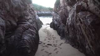
OVERNIGHT SLEEP ON THE BEACH SWAGS ROLLED OUT Exploring uninhabited islands in Western Australia. No mangroves. Clear warm water. No crocs. Of course, strictly speaking, anywhere in the Kimberley is crocodile habitat. A large chasm receded back into cliffs on this particular beach foreshore. At the far end of the beach away from our overnight swags. Receding into the cliffs perhaps fifty metres or so. The rock face smoothed by tides and storms. Damp sand was felt underfoot with a low tide and sounds of small birds twittering up above in the clifftop trees. The yellow beacon light carried from our tender staked in the beach sand still flashing in the early morning light. Beach swimming is generally regarded as safe on islands far from the coast away from coastal mangroves. Swimming in a pure environment, shipmates and crew explore uninhabited islands together. Kimberley of Western Australia Surrounded by Kimberley rock structures weathered into strange shapes and various colours. The huge high tide marks on rocks are a testament to the powerful forces of nature at play. These marks, etched into the rugged surface of the rocks, tell a story of the relentless ebb and flow of the tides. Each mark represents a moment in time when the sea surged forward with immense strength, leaving its mark for all to see. The sheer size of these tide marks serves as a reminder of the sheer power of the ocean, shaping the coastline over countless years. As the waves crash against the rocks, carving out new patterns and designs, the high tide marks stand as a silent witness to the ever-changing dance between land and sea. Sometimes impromptu Kimberley sand crab racing was arranged. A few crabs moved quickly to the outer circle drawn in the sand. Others not so. Make your own fun in these remote islands. Frequent swimming is enjoyed in the warm sea by some. All enjoying cruising the untamed Kimberley Islands of Western Australia. Traveldriven A large natural split receding back into the rock cliff. Smoothed by high water tides ON THE BEACH WINTER SWIM TEN METRE TIDE MARK EXPLORE UNINHABITED ISLANDS NOTE THE HIGH TIDE MARK BEHIND THE WALKERS KIMBERLEY ISLANDS SUNSET CRAB RACES ONLY IN THE KIMBERLEY PREV KIMBERLEY ISLANDS NEXT
- SURFING WAVE ROCK
UNIQUE ROCK FORMATION Of course, surfing the rock is not possible, despite the vivid mental image that may come to mind when one thinks of such an activity. This striking natural rock formation, known as Wave Rock, is located near the town of Hyden, which is situated a few hours' drive east of Perth in the picturesque Western Australian wheatbelt region. Wave Rock stands an impressive fifteen metres tall and stretches approximately one hundred metres in length, creating a breathtaking spectacle that draws visitors from near and far. Its unique appearance resembles a massive, frozen wave of water, capturing the imagination of all who encounter it and evoking thoughts of the ocean, even though it is far from any coastal area. This remarkable granite cliff face was formed millions of years ago, shaped meticulously by the forces of erosion and weathering over thousands of millennia. The natural processes that contributed to its formation have left behind a stunning geological feature that showcases the beauty and power of nature. Visitors can explore several walking tracks that meander around the base of Wave Rock and one leads up to its summit, offering views of the surrounding landscape. These hiking paths provide an excellent opportunity for both casual walkers and avid hikers to appreciate the natural beauty of the area while learning more about the geological history and significance of this iconic landmark. Adjacent to Wave Rock is a dam that plays a role in collecting rainwater from the rocky landscape. Historically, this dam served as an essential water supply for the town of Hyden. AROUND WAVE ROCK Onsite, visitors will find the Wave Rock Caravan Park & Resort, which offers a range of accommodations for those wishing to stay longer and fully immerse themselves in the stunning surroundings. In addition to the caravan park, there are several small museums under one roof within an easy short walk. One of the museums is dedicated to other collections of non-indigenous collectables such as toys. A café is also available, where guests can relax and enjoy refreshments after taking in the views of the remarkable rock formation. It is worth noting that a small fee is required to access Wave Rock and is payable at the caravan park office. The museums also have a small entry fee. Traveldriven DRIVE MORAWA - WAVE ROCK WAVE ROCK WALK ALONG THE FACE THE FACE OF WAVE ROCK WAVE ROCK CARAVAN PARK AND CAMPING AREA INSIDE WAVE ROCK SHOP & MUSUEM PREV AUSTRALIA 2025 NEXT
- MUSTANG GT NEW CAR READY FOR DRIVING
FORD MUSTANG GT & DRIVING The right-hand drive variant of the Mustang is built in Flat Rock, Michigan USA. Right-hand drive has been factory built since 2015. Ecoboost and V8 models are available. Ford dealership changed the front silver pony and both silver 5.O Litre side badges for black the week I took delivery. This was done for a small cost. The first new car I have ever owned. I expect the only new car I will ever own as well. Primary brought for the driving experience of a Mustang GT. Not for show display or Sunday fair weather driving. The first out of town drive was to Ballarat in Victoria. On a cold, wet and rainy day. During the winter months there is often a threat of light hail in the Ballarat area. Mustang was uncovered overnight and no car cover, carport or garage was available. There were showers of sleet rain overnight. Traveldriven MUSTANG GT BLACK PONY OFFICIAL MUSTANG DRIVER AND OWNER BLACK PONY NEW MUSTANG ON THE ROAD WITH BLACK & WHITE NUMBER PLATES MUSTANG SINCE 1964 INTERNAL BADGE New car in showroom. Yet to be driven. FIRST WEEK OF OWNERSHIP PARKED OVERNIGHT OUTSIDE VERY LIGHT SHOWER OF HAIL STONES NEW DAY & NEW CAR READY TO DRIVE PREV MUSTANG GT NEXT HOMEPAGE
- MUSTANG & RELEARNING TO DRIVE WITH CIDP
REGAINING ABILITY TO DRIVE 6 SPEED MANUAL MUSTANG GT... Medical approval was given to drive a private motor vehicle after four plus months of impaired mobility caused by CIDP. C hronic I nflammatory D emyelinating P olyneuropathy. (CIDP) Now able to park a car in a garage on first attempt after initial self-imposed no driving followed by complete loss of driving function. After a period of eighteen weeks and receiving medical approval. Also, after another additional month of privately arranged driving supervision, it was deemed safe to resume driving and allow driving once again on the open road. No driving aids or vehicle modifications were required. No licence restrictions were placed on automatic or a manual gear shift for a private motor vehicle. In future, medical advice on driving competency to be served to the licensing authorities when required. However, on strongly advised personal medical advice for my own circumstances of CIDP, driving was self-restricted to the local regional area for greater than twelve months because of chronic fatigue of limbs in both arms and legs. All medical advice was considered and followed. Also read all Traveldriven CIDP posts if interested. Begin with CIDP Improvements Five Years Go to post Traveldriven RELEARN TO DRIVE MUSTANG GT DRIVE TEST 1 CAR PARK DRIVE TEST 2 QUIET COUNTRY ROAD... & AVOIDING KANGAROO'S DRIVE TEST 3 HIGHWAY DRIVE RELEARNING TO DRIVE DRIVE TEST 4 TOWN DRIVE RELEARNING TO DRIVE FIRST SOLO DRIVE THE LONG ROAD TO RECOVERY? Chronic Inflammatory Demyelinating Polyneuropathy PREV MUSTANG GT NEXT HOMEPAGE
- MUSTANG GT KEEP EYES PEELED, COVID-19 WORLD AND CAMERA MISHAPS
ON COUNTRY ROADS Watch out for roadside wildlife. Kangaroos are generally the most frequent wildlife that vehicles collide with on Australian roads. Also roaming livestock are a hazard. Many rural roads, even highways are unsealed. Some in need of major upgrades or waiting repair. Most but not all, have safety signage to warn drivers. During Covid-19 and Driving a Mustang GT The movie "I Am Legend" featuring a Ford Mustang GT is a thrilling cinematic experience that captivates audiences with its high-speed action and intense storyline. The powerful performance of the Mustang GT in the movie adds an extra layer of excitement and adrenaline to the film, making it a memorable experience for car enthusiasts and moviegoers alike. Comparing driving in the COVID-19 world to the movie trailer raises interesting questions about the future of driving and transportation. While the trailer may depict a fast-paced and exhilarating driving experience, the reality of driving during a global pandemic is quite different. With social distancing measures in place and increased awareness of health and safety concerns, the way we drive and interact on the road has evolved to prioritize safety and well-being. Despite the differences between the movie trailer and real-world driving conditions, both scenarios share a sense of adventure and unpredictability. Just as the characters in "I Am Legend" navigate a post-apocalyptic world filled with challenges and obstacles, drivers in the COVID-19 era had to adapt to new norms and regulations while still finding joy and excitement in the act of driving. Camera setups on car Fun video camera car attachment angles on a quiet country road. Camera is secure up to town speed limit. Unsuitable for highway or general town driving. Traveldriven DRIVING EYEBALL MUSTANG GT DRIVING COVID-19 WORLD POST 3RD WAVE? REAL LIFE IMITATING ART? JUST KIDDING. MUSTANG DRIVING SCENE FROM 'I AM LEGEND' DRIVING DURING COVID-19 PANDEMIC LOCKDOWN NOT THE MOST PRACTICAL CAMERA POSITION LOW SPEED ANOTHER CAMERA TEST ON A COUNTRY ROAD LOW SPEED CAR CAMERA POSITION TEST LOW SPEED CAR CAMERA POSITION TEST 2 LOW SPEED CAR CAMERA POSITION TEST 3 LOW SPEED CAR CAMERA POSITION TEST 4 LOW SPEED PREV MUSTANG GT NEXT HOMEPAGE
- CIDP IMPROVEMENTS DRIVES, HIKING AND MOTORBIKE RIDING
CHRONIC INFLAMMATORY DEMYELINATING POLYNEUROPATHY (CIDP) Medical investigators analysed clinical patterns, biopsy findings, and functional capacity in 100 patients. The disease was gradually progressive in 45% of patients, relapsing and remitting in 14%, and monophasic, (one initial occurrence lasting possibly three years or more) in the remainder. Showing CIDP improvement is possible. The sample base was small so an expanded sample study would give a more accurate representative picture of chronic inflammatory demyelinating polyneuropathy in clinically diagnosed patients. However, a baseline study is useful as a guide. Also read page post on regaining ability to drive. CIDP Driving Improvements An unofficial first drive test with a six-speed manual. Drive test 1 Carpark Drive test 2 Quiet country road Drive test 3 Highway drive Drive test 4 Town drive Go to post Traveldriven CIDP MUSTANG GT FIRST SOLO DRIVE FIRST ONE DAY ROAD TRIP AFTER CIDP MEDICAL CLEARANCE IN THE VICTORIAN COUNTRYSIDE FIRST AWKWARD BUT COMPETENT MOTORBIKE RIDE CIDP GIBSON STEPS, & THE GREAT OCEAN ROAD FIRST ATTEMPT WITH CIDP HILL WALK FIRST ATTEMPTS AFTER FIFTEEN MONTHS OF CIDP PREV CIDP NEXT HOMEPAGE