YOUR NEXT TRAVEL EXPERIENCE
Search Results
274 results found with an empty search
- PATIENT INSIGHT, TAI CHI AND SIX TO TWELVE MONTHS OF CIDP
CIDP AND TAI CHI Exercises that promote muscle strengthening and aerobic conditioning are important once patients have received clearance from a physician for an exercise program. Maintaining physical exercise is important for people diagnosed with CIDP. Especially since the completion of regular outpatient hospital physio programs. In my instance ending after twelve months. An online search will reveal benefits of regular Tai Chi practice in those people with peripheral neuropathy and may help to lesson inflammation caused by Chronic Inflammatory Demyelinating Polyneuropathy. My first-hand experience has been very positive. From about two years after diagnosis of CIDP I sought out a means to exercise at least once or twice per week. Exercise suitable for the limitations of weakness and fatigue bought about by CIDP. This led to trying Tai Chi. CIDP AND GROUP SUPPORT Of course, there are challenges but overall, a good way to keep an exercise program for the long term. A once or twice per week group setting of Tai Chi helps with motivation. Much of Tai Chi is based on form work and not hard physical activity. Gradually stable footing and controlled breathing techniques are taught over time. Much at one's own level of mobility. As a person progresses and if capable, advanced Tai Chi requires and if desired, more physical activity and more precise balance and even weapon's training in form work. Tai Chi is a non-contact sport suitable for all ages and levels of health. I personally know of people in their eighties attending classes. Traveldriven SIX MONTHS OF CIDP HOSPITAL PATIENT CIDP INSIGHT CIDP RECOVERY SMALL IMPROVEMENTS CIDP RECOVERY IS POSSIBLE CIDP RECOVERY WITH VR TWELVE MONTHS OF CIDP PREV CIDP NEXT HOMEPAGE
- BEAUFORT SHOW & SHINE 2025 & 2023
Beaufort is a charming town situated in Victoria, Australia, nestled along the Western Highway between the bustling cities of Ararat and Ballarat. Despite its small size, with a population of less than two thousand, Beaufort holds a unique appeal for visitors and locals alike. Located approximately one hundred and sixty kilometres (102 miles) west of Melbourne, this town boasts a serene atmosphere and a close-knit community. One of the highlights of Beaufort is its thriving café scene, with numerous establishments offering breakfast options that cater to various tastes. Among these, the Red Kangaroo Roadhouse stands out, located just beyond the Western Highway railway overpass, providing a convenient stop for travellers passing through the area. Beaufort Show & Shine An event that draws both locals and visitors to Beaufort is the Beaufort Truck Show & Shine, known for its fundraising efforts in support of the local football and netball clubs. This event, held annually in March on the Australian Rules football oval and its surroundings, features live music performances, merchandise stalls, and BBQ vendors serving up delicious treats for attendees to enjoy. During the event, the football oval transforms into a showcase of display cars, while the surrounding grounds come alive with impressive truck displays and various stalls offering a range of goods. The community spirit shines through during the Beaufort Truck Show & Shine, making it a must-visit occasion that celebrates the town's unique character and supports its local sports clubs. Traveldriven BEAUFORT TRUCK & CAR SHOW 2025 BEAUFORT CAR & TRUCK SHOW 2023 FIVE BULLET HITS All through the boot (decals) Right hand side pipe. Nice two tone and lowered LOWERED to the grass. Not keen on the grey paintwork Rear wheel completely covered by removeable panel. Early model MUSTANG 351 engine. Side body scoop. FORD MUSTANG 351 emblem on bonnet 'MAD MAX' ORIGINAL 1979 MOVIE REPLICA WITH ROOF RACK & SIDE PANEL MURAL 1975 HOLDEN SANDMAN PANEL VAN MAD MAX HOLDEN SANDMAN PANEL VAN 1975 PREV SHOW & SHINE NEXT PREV VICTORIA NEXT HOMEPAGE
- GET YOUR THRILLS ON ONE TREE HILL, ARARAT JAILHOUSE ROCK & HILL CLIMB
Ararat is a city in south-west Victoria about two hundred kilometres (120 mi) west of Melbourne, on the Western Highway. About one hundred km from Ballarat along the Western Freeway. The freeway converting to highway twenty-five km from the city. Has a population of less than ten thousand residents. Located on the Great Dividing Range. Ararat Jailhouse Rock Festival Held on the weekend after the long weekend in March. The festival begins on the Friday night with a classic car cruise along Barkly Street in Ararat. The main retail street of the town. Followed by a ticketed Rock 'n' Roll Revival show inside the Town Hall. Events and live music are on Saturday and Sunday. One such event is the Saturday morning: Show us your wheels. This event is held in Barkly Street opposite the Town Hall. Open to all types of vehicles and is hosted by Grampians Vintage and Veteran Car Club. One Tree Hill Climb The hill climb is held twice per year. A large hill on the fringe of the town. Height of 1,900 feet above sea level. The track length being 1609 metres in length. Held over a weekend in June and November. The event is generally a round of the Victorian Hill Climb Championship. The Hill Climb is free to watch and many of its entrants come from interstate. Usually, onsite BBQ food is available to purchase. The event is frequented by local car and motoring enthusiasts and organised by the Ararat Car Club Inc. One Tree Hill has a small rotunda at the top and a carpark. The sealed road is rather steep but nice to drive. Not suitable for towed vehicles. Must be thrilling to drive as an entrant in a Hill Climb. Views of Ararat and on the other side of the hill views to the Grampian mountains. Traveldriven DRIVE ONE TREE HILL, ARARAT A hill climb cyclist detailed account of One Tree Hill http://theclimbingcyclist.com/climbs/one-tree-hill-ararat/ ENTER CLICK/TAP ARARAT GOOGLE MAPS DRIVING ARARAT CITY JAIL HOUSE ROCK & SHOW\SHINE 2025 Show Us Your Wheels 2024 JAILHOUSE ROCK MERCHANDISE HOT ROD FLAMES SHOW US YOUR WHEELS MOONSHINE DELIVERIES ARARAT JAILHOUSE ROCK WEEKEND SUMMIT OF ONE TREE HILL, LOOKING OVER ARARAT VIEWS OF THE GRAMPIANS ARE BEHIND CAMERA ONE TREE HILL, HILL CLIMB HILL CLIMB IN CAR CRASH ARARAT HILL CLIMB JUNE 2023 ARARAT HILLCLIMB 2015 ARARAT HILL CLIMB 1993 PREV VICTORIA NEXT HOMEPAGE
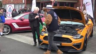
- MUSTANG ROUNDUP 2019 DANDENONG, MELBOURNE
DANDENONG An outer suburb of Melbourne, twenty-nine km south-east from Melbourne CBD. It is over twenty km from the Dandenong Ranges and unrelated to that area. Dandenong's population is greater than thirty thousand residents. A strong car culture exists. Mustang Roundup The Mustang Roundup was attended by hundreds of mustangs and their owners. Old and new cars. The unveiled Mustang R Spec a very popular car with the crowd. Bright green and black. A high spec car and a high new price tag. Mustang Motorsports displayed a few Roush spec cars. Many early era mustangs on display. Even the Cobra coupe open top cars were on show. Interestingly, in their own separated display area. Traveldriven ENTER CLICK/TAP DANDENONG GOOGLE MAPS MUSTANG ROUNDUP 2019 MUSTANG R SPEC BRIGHT GREEN AND BLACK MUSTANG SUPER SNAKE NAME ON RIM CARPARK FULL OF MUSTANGS MUSTANG MURAL ON SIDE DOOR AFL TIGER COLORS MUSTANG AND BLACK STRIPE AFL TIGER MUSTANG NUMBER PLATE NOT MUSTANGS, ALL WELCOME ALL HAVE SAFETY ROLL OVER BARS SIDE PIPES ROUSH POWERED MUSTANG EARLY MUSTANG 289 ci BONNET SCOOP PERHAPS TOO LARGE? CARPARK FILLED WITH MUSTANGS & DRIVERS STEVE McQUEEN EDITION MUSTANG STEVE McQUEEN EDITION ENGINE CAR & BIKE SHOW TAPCORP PARK PACING TRACK, MELTON PREV SHOW & SHINE NEXT HOMEPAGE
- BE PREPARED ICE & SNOW, MOUNT WILLIAM IN THE GRAMPIANS
Mount William The tallest mountain of the Grampians National Park. A little over twenty kilometres drive from Halls Gap. Mount William may be reached along the Halls Gap to Dunkeld road named Grampians Road. Drive from Halls Gap and pass Lake Bellfield. Mount William is the highest point within the Grampians National Park at 1,167 metres or 3,829 feet in height. Three transmission towers are located on the summit of Mount William. The transmission towers were impacted by the Grampian bushfires of December 2024 and into 2025. Often in winter the towers are coated in ice or snow. A very steep sealed service road continues to the summit from the carpark. This road may be walked but is out of bounds for non-parks vehicle traffic. The Mount William carpark is about eight km from the Grampians Road turnoff. All sealed road and scenic views. The drive is ok for those that don't like heights. Mount William Walk Once at the carpark people can proceed on foot to the summit by following a very steep sealed service road just short of two km to the summit from the carpark. Usually, the walk is very cold in winter and hot in summer. No roadside shade is available walking to the summit. The summit walk is open year round and many take ninety minutes or so to complete the return walk. It's not uncommon for the summit of Mount William to receive winter snow. Views are to the plains of Western Victoria and to the nearby Major Mitchell Plateau which can be hiked taking many hours and planning. Traveldriven ENTER CLICK/TAP MOUNT WILLIAM GOOGLE M APS DRIVE HALLS GAP TO MOUNT WILLIAM CARPARK VIEW FROM WINTER WALK TO THE SUMMIT OF MOUNT WILLIAM WALK FROM CARPARK ALONG AUTHORISED VEHICLES ONLY SEALED ROAD MOUNT WILLIAM SUMMIT VIEW TRANSMISSION TOWERS IN WINTER SNOW TOWERS IN SNOW DRIVING MOUNT WILLIAM MOUNT WILLIAM CARPARK SUMMER PREV GRAMPIANS NEXT PREV VICTORIA NEXT HOMEPAGE
- WALK IN THE SKY, KALBARRI SKYWALK
DRIVE OCEAN TO SKY IN KALBARRI Kalbarri is a coastal town situated approximately sixty kilometres from the North West Coastal Highway, nearly six hundred kilometres north of Perth. The Skywalk in Kalbarri National Park is not for the faint-hearted. It opened in 2020 and is about a thirty-minute drive from the town of Kalbarri along a fully sealed road suitable for two-wheel drive vehicles. Those who are uncomfortable with heights might choose to visit the onsite café instead. The cafe is directly behind the Skywalk. The gorge could be considered Australia's Grand Canyon, with the Murchison River winding far below through the impressive valley. KALBARRI SKYWALK To access the Skywalk, a national park pass is required, and all roads are paved. Sheer red rock drops more than one hundred metres or well over three hundred feet to the valley floor beneath the Skywalk deck. You can purchase a park pass at the entry booth staffed by National Park personnel. Dogs are not permitted in the park, and towed vehicles are prohibited. The drive to the Skywalk carpark and the nearby Natures Window carpark is relatively flat, but both are situated on high ground. The area is very popular and attracts many visitors. There are in fact two skywalks within sight of each other. Only a few minutes of flat walk separates them. The larger platform extends twenty-five metres from the cliff face, which is four metres longer than the Grand Canyon Skywalk in the USA. The second platform extends seventeen metres. Both platforms are V-shaped, and the larger Skywalk includes a short crossover bridge within the structure, allowing those with a fear of heights to effectively walk half of the full overhang platform. Traveldriven KALBARRI GOOGLE MAPS DRIVE CARNARVON - KALBARRI - SKYWALK SKYWALK OVER VALLEY 25 METRES OF OVERHANG KALBARRI SKYWALK SIGNAGE ON THE WALKWAY TO CAFE & SKYWALK THE EXPANSIVE VIEWS WIDE WALKING PLATFORM CAFE FOOD AND DRINKS ROADSIDE BLACK BOY GRASS TREES NUMBERING IN THE HUNDREDS DRIVING TO THE SKYWALK PREV AUSTRALIA 2025 NEXT
- TAKE A REST BREAK IN OUTBACK PINE CREEK
TAKE A BREAK IN PINE CREEK Do not make the mistake of by-passing Pine Creek on the way to Darwin, Kakadu or Alice Springs. This charming little town serves as a convenient overnight rest stop for weary travellers seeking a break from the long stretches of road. Upon entering the small Outback town, you will discover an unspoilt gem nestled within the rugged Australian landscape. Located approximately two and a half hours' drive away from Darwin, Pine Creek is strategically positioned yet often overlooked, as it is by-passed by the main North-South highway, making it easy to miss. The town's rich history is rooted in the discovery of gold, which played a pivotal role in its establishment and growth, leaving behind a legacy that is still celebrated today. THE LAZY LIZARD AND THE SHED The Lazy Lizard Tavern and Caravan Park is one of Pine Creek's notable attractions, offering a variety of experiences that cater to different interests. Among its remarkable features is "The Shed," which houses a fascinating private collection of Australian motor vehicles alongside an impressive array of motorbikes from various makes and models. This extensive collection is contained within a spacious shed that invites visitors to explore the evolution of Australian automotive history. A small fee is charged to view the collection, and all proceeds are generously donated to the Melanoma Institute of Australia, making your visit not only enjoyable but also beneficial to a worthy cause. Often on site are quirky characters, such as The Shed caretaker, who is known for his engaging stories and anecdotes about the vehicles, and his pet blue tongue lizard, adding a unique charm to the experience. The Tavern itself is a delightful spot where guests can indulge in fresh homemade pizzas served throughout the day, complemented by the refreshing taste of Lazy Lizard beer, which is proudly available on tap. PINE CREEK Pine Creek truly offers a refreshing and relaxing break from the long days of travel on the open road. It provides an opportunity to stretch your legs, enjoy the local hospitality, and immerse yourself in the history and culture of the area. It's important to note that the Kakadu turnoff is located on the bypass section of the road; therefore, it's crucial to be mindful while driving into Pine Creek. Many travellers have unwittingly driven into the town and out the other side, only to realise too late that they have missed the signage directing them to enter Kakadu National Park. This beautiful national park is a treasure trove of biodiversity, stunning landscapes, and rich Aboriginal culture, making it an essential stop on your journey. So, take the time to enjoy everything Pine Creek has to offer and ensure you don’t miss the opportunity to explore the wonders of Kakadu. Traveldriven DRIVE PINE CREEK - DARWIN PET BLUE TONGUE LIZARD SALTWATER CROC SKULL THE LAZY LIZARD TAVERN AND SERVICE STATION INSIDE THE LAZY LIZARD TAVERN CROC SKINS ON THE ROOF THE SHED DISPLAY AND THE BLUE TONGUE LIZARD PREV AUSTRALIA 2025 NEXT
- TRAVELDRIVEN HOME PAGE
Traveldriven Travel Experiences. Welcome to the Home Page of the Traveldriven website. All are welcome to browse page posts and leave a comment. There are upwards of two hundred and seventy individual page posts. All posts have commentary, photos and videos. Why Browse Traveldriven? Needless to say, we all only want to know about and see what we are interested in. In the quickest and easiest way. Preferably, with an honest firsthand insight and personal experience. This is what Traveldriven is about. Also sharing a few amusing, and a few concerning travel experiences. To share the driving experience and destination. The good and not so good. You and others might also want to go out and see these locations firsthand. All are free to browse page posts for travel ideas. The purpose is to show pictures and videos to those who don't know or have little knowledge of how large and diverse Australia the land and people are, a glimpse of the vast country of Australia. Why Not Fly Within Australia Instead of Drive? Aside from capital cities, only the largest major regional hubs are served by domestic commercial jet flights. This includes Australia's tropical northern centres like Broome in Western Australia, and Cairns, Townsville, and Hamilton Island in Queensland, as well as the Gold Coast near Brisbane. In the central Outback, Alice Springs and Uluru (Ayers Rock) in the Northern Territory also have airports serviced by commercial jet carriers. During the tourist low season of the northern wet season summer months in Australia, when flooding cuts off many roads, and the countryside is lush and green, low airfare jet flights to northern Australia might be more practical. From a flights and accommodations budget point of view. Although once on the ground, the frequent storms and the uncomfortable oppressive humidity make getting around difficult and would be fairly restrictive. The northern Australia monsoon season especially from December to March brings widespread flooding and road infrastructure damage. In short, the winter months of June, July, and August are ideal for travelling to northern Australia. Additionally, relying solely on domestic commercial jet flights with minimal or no driving means missing out on the most picturesque parts of outback Australia. Fly and Drive, Rail or Road Trip? Numerous larger town airports in Australia provide domestic regional flights operating smaller passenger light aircraft; however, these flights are typically quite costly and may not operate daily. Rail travel is an alternative, but it usually is quite expensive for several days of interstate journey by sleeper rail car. None offer the flexibility of a road trip and the convenience of a road vehicle for many weeks or months of travel. To state the obvious, sightseeing and stopping at random places of interest is impossible from a commercial flight. Flying and renting a car is another option for short trips of a week or two, but total travel costs increase significantly for longer journeys without your own vehicle. Be aware, even to fly and drive, travelling for less than two weeks in the Outback imposes an unrealistic time constraint to see all but a few of the top attractions on one trip. Many travellers may have to preplan and cherry pick just a few outback attractions if the available time is less than two weeks. More time is essential to explore more than just a small snippet of the vast array of interesting locations in the northern and central regions. That's not to say a short trip can't be fantastic if expectations are kept realistic. Travel Vehicles We have all seen the fancy travel rigs. A hundred and fifty thousand dollars or much more for the vehicle and towed travel van. All well and good for those with the budget. Traveldriven has used swags, small tents, basic vans, motels and bush hotels. Some of the most commonly seen vehicles sold in Australia have been driven on travel trips. These range from family sedans (Ford Falcon), sports cars (Mustang GT) to SUVs. All Traveldriven trips pre-2025 are without a towed vehicle. See What Is Out There It's not about what means of travel you have or budget but getting out there and doing. Bei,ng solo, with family or friends. All Traveldriven posts are about places where ordinary travellers may like to go. Travellers like you and I. Almost all destinations in mainland Australia on this website are within reach on sealed bitumen roads. Without the need to own or hire an expensive long range offroad specialised vehicle. Just everyday driving skills are required. With a little basic knowledge and common sense. You can drive to extraordinary locations. Enjoy, relax and to seek out new places of interest. Having said that, depending on the time, place and local events, things happen. Read the following to quickly go to a page post of interest. A few posts are of places not within Australia. It's great to gain a perspective on life outside of the country of birth. If only to compare and appreciate your corner of it. Traveldriven TAKE AN OUTBACK BREAK BIRDSVILLE, QUEENSLAND TRAVELDRIVEN ONE MINUTE SNAPSHOT Australia and Bushfire Survival Every State in Australia is of risk of major bushfire breakouts. It is good to know the basic do's and don'ts in these fire prone environments. Not only overseas visitors but residents of Australian cities travelling to country area's should know how to pay heed to the dangers. A Traveldriven first hand example is given in the following post: https://www.traveldriven.net/single-post/bushfire-wildfire-or-forest-fire-survival Timber Creek, Northern Territory Australia is generally a safe country for travelling by road. However, be cautious of potential issues with wildlife and people. For first time Outback drivers a safe Outback option is to stay within the National Australia Highway Network, which offers good roads and communication. Many sealed highways, but not all, have mobile phone coverage. It's not uncommon for no phone or GPS reception for hours of driving. All sealed highways have some daily traffic and travellers if in need of outside help will get assistance from other travellers. Nevertheless, Outback areas remain very remote, often with police, hospital and vehicle breakdown services three to four hours away by car. It is foolhardy and may be life threatening to rely on or expect help from patchy or non-existent mobile phone reception in the event of an emergency. At a minimum an inflated full size spare tyre and ten litres of drinkable water should be carried for safety and peace of mind. Timber Creek is a small outback settlement 185 km from the Western Australian border. Read how serious situations may develop from doing nothing wrong. Encountering local wildlife endemic to the tropics (not saltwater crocodiles) and people. Go to Page post: https://www.traveldriven.net/single-post/australia-big-righthand-turn-2 South Pacific Islands Vanuatu and Inyeug Island. Stories of head-hunters and the visiting cruise ships. The islands are nearer to Sydney than Sydney is to Perth in Western Australia. Go to Page post: https://www.traveldriven.net/single-post/south-pacific-island-of-inyeug Cruise Kimberley Islands Hop aboard the MV Oceanic. A converted Rottnest Island ferry. Adventure cruise the Kimberley Islands of Western Australia for seven days. A firsthand experience of what sights to expect to see and the experiences in this offshore region. Tourist requirements are really just to have the ability to walk for five minutes or so and have a curiosity of the truly spectacular scenic Kimberley Islands unfolding all around. Both in seascape and landscape. Go to Page post: https://www.traveldriven.net/single-post/australia-cruise-kimberley-islands-mvoceanic Great Barrier Reef Islands Whitehaven in Queensland, Australia's most famous beach non-Australian's have probably never heard of. Whitehaven truly lives up to expectations. Just a short inexpensive daily tour boat trip from Hamilton Island. Go to Page post: https://www.traveldriven.net/single-post/2020/05/31/whitehaven-beach Hamilton Island & How to Sail Solo Hamilton Island is a major tour mecca of the Great Barrier Reef. Serviced by all major Australian airlines and capital cities. Read how its done to sail cheaply and solo with little to no sailing experience on a four man catamaran. Go to Page post: https://www.traveldriven.net/single-post/2020/05/31/hamilton-island Australia Travel Icons Who hasn't heard of the Twelve Apostles on the Great Ocean Road in Victoria! Within eyesight are the Gibson Steps. Take the one hundred cliffside steps down to the beach. Wild surf batters the beach. Breathe in the salty air. Don't do a Harold Holt (ex-Prime Minister) who disappeared in Victorian waters. If you enter the water of rips and currents at one's own pearl. You will probably never be seen again. Go to Page post: https://www.traveldriven.net/single-post/2020/05/31/twelve-apostles Road Trip Western Australia Northern Territory South Australia Australia's big right-hand turn. Day one of a solo road trip driving a Ford Falcon sedan from Victoria. A glimpse of the attractions that await travellers planning a road trip to the West. Go to Page post: https://www.traveldriven.net/single-post/2017/07/11/australia-big-right-turn-day-1 Road Trip to Townsville, Queensland Day one of a three-week solo road trip to Townsville driving a Ford Mustang GT V8 from Victoria. Including a visit to Ned Kelly country. Australia's most famous bushranger. Don't miss the roadside attractions along the trip, such as tossing a coin to the Dog On The Tuckerbox. Discover which roadside attractions are truly worth visiting. Go to Page post: https://www.traveldriven.net/single-post/2019/03/18/driving-to-queensland Road Trip to Silverton, Outback New South Wales A special weekend event to celebrate the 40th year of the release of the second Mad Max film. Parts of which were filmed on set around Silverton with Mel Gibson and crew. Enthusiasts dressed in movie theme attire. Road going replica vehicles and of course the Wasteland Compound. Do your own Mad Max adventure and drive to Silverton. Inspect the sites and see movie props and movie memorabilia. Go to Page post: https://www.traveldriven.net/single-post/silverton-outback-australia Road Trip to Tasmania Day one of a road trip to the island state of Tasmania. Driving a Mustang GT. Start of trip was on the Spirit of Tasmania car ferry Victoria to Devonport, Tasmania. What to expect on the ferry and small town tourist sights. Attractions that are worth a stop along the way to Hobart. Go to Page post: https://www.traveldriven.net/single-post/2018/02/18/mustang-gt-search-box Road Trip to Canberra Australian Capital Territory Day one of a solo road trip to Canberra driving a Mustang GT. Passing through Bendigo, Victoria and a visit to the Great Stupa. A free attraction for all. Canberra is not boring as many from Sydney or Melbourne will try to tell you. Get an insight on a few Canberra locations and buildings you should visit on your next trip. Many are free to experience. Includes a two-day detour to the famous Bathurst Motor Racing Circuit and unlimited driving time of the track. How you can drive Mount Panaroma within the law and still have enjoyment. Go to post: https://www.traveldriven.net/single-post/bendigo-art-silo-s-ned-kely Road Trip Outback 4WD Basically, anyone could do this with just an interest in the Outback and nothing else required apart from the tour cost. Day one of a nine-day road trip tour to Birdsville in Outback Queensland in a Toyota Landcruiser V8 from Adelaide. Costing roughly five hundred dollars per day (as of 2025 in Aus.$). The tour operator drives the vehicle and includes, meals, and unit or hotel accommodations for the entire trip. Go to post: https://www.traveldriven.net/single-post/work-in-process-road-trip-birdsville Grampians National Park First hand local information about the Grampians National Park and Halls Gap in Victoria. Less than a few hours' drive from Melbourne. Other websites barely mention the Park if at all. It is one of the best accessible Parks to all road going vehicles year-round within Australia. View spectacular and accessible mountain scenery. Go to Page post: https://www.traveldriven.net/single-post/wildlife-of-the-grampians-national-park Road Trip Bend Motorsport Park Within an hour's drive from Adelaide. Drive to the riverside town of Tailem Bend in South Australia and drive your own vehicle around the world class track. Track sessions are only allowed on pre-booked designated track experience days. Vehicle must be roadworthy. The racetrack driving experience is cheap and safe. High speeds are obtained. A full thirty minutes on track time. Go to Page post: https://www.traveldriven.net/single-post/tracktime-the-bend-motorsport-park Road Trip New Zealand Driving New Zealand on the South Island and a day's visit to White Island volcano on the North Island before the deadly eruption and the tourist ban. Discover Arrowtown and Queenstown attractions. Drive the scenic valley along State Highway 94 to Milford Sound via the Homer Tunnel. Agreed by many to be New Zealand's most scenic highway. View snowcapped Mt Cook from your hotel room. Touch a floating iceberg on a glacial lake. Go to Page post: https://www.traveldriven.net/single-post/2019/04/20/arrowtown Road Trip Ireland For anyone planning on visiting Ireland consider driving around Ireland. If budget allows, visit and gain fine lodgings at Ashford Castle. Or perhaps for more value for money visit and stay overnight in a haunted Castle such as Ballyseede Castle. You might experience a supernatural encounter with Hila the friendly ghost. Read what to expect as a guest and a personal non-frightening ghostly experience. Go to Page post: https://www.traveldriven.net/single-post/2017/04/15/driving-around-ireland-2015 Scotland & Nessie of Loch Ness Embark on a Loch Ness cruise across the renowned lake. On one particular lake tour, tourists on the Loch hear a factual account of the legend from a guide. The talk captured on video. The presence of sizeable aquatic creatures in the Loch's depths may contribute to the legend, though it's not what most tourists typically imagine. Hear the guide's explanation. Visit the Page post: https://www.traveldriven.net/single-post/2019/06/02/loch-ness RETURN TO TRAVELDRIVEN.NET
- DRIVING THE NULLARBOR PLAIN
BALLADONIA TOWARDS THE NULLARBOR PLAIN The indigenous word Nullarbor translates as, 'place of no trees'. The distance from Balladonia, Western Australia and traversing the Nullarbor Plain to Kimba in South Australia is 1,300 km. The journey west to the eastern states and the remote Nullarbor Plain from Western Australia truly starts at Balladonia. This is little more than a roadhouse. After passing through Balladonia towards South Australia, the ninety-mile straight begins. This section of the Eyre Highway extends straight for 147 kilometres and then the highway continues towards Eucla. Rainfall in this part of the country is typically quite unreliable. However, this time, the expression "it's raining cats and dogs" was fitting. The entire ninety-mile road was covered with rivers of water along the length of the highway. Rivers of rainwater flowing along where normally vehicle wheels are supposed to be. To prevent constant aquaplaning, even at a reduced speed, driving had to be down the centre of the highway whenever there was no traffic. Fortunately, traffic was very light, allowing for safer driving in the extremely wet conditions. To avoid night driving in such bad weather, an overnight stop was decided upon in Nundroo. This turned out to be a wise decision, as many fellow travellers the next morning remarked about the intense overnight gale-force winds and rain they experienced. Any rain on the Nullarbor is always a rarity. The roadside signs welcoming travellers to Sunny Eucla were quite amusing given the persistent rain. EUCLA Eucla's population hovers around thirty to fifty, and Eucla is situated on the Western Australia side of the border and serves primarily as a service stop for travellers. There is a manned police station and a small, staffed health service. From the outside, the roadhouse amenities and accommodations appear clean and modern. Behind the roadhouse, there is even a landscaped pool area with shade. Eucla to Border Village (roadhouse) in South Australia is about thirteen km. There is no fruit quarantine stop to enter South Australia as there is driving from the other direction to enter Western Australia. NULLARBOR The Nullarbor Roadhouse is a service and accommodation stop for travellers on the Eyre Highway, South Australia. Fuel is available along with a small caravan park and motel units. NUNDROO Personally, I would not recommend an overnight stay in Nundroo, South Australia unless necessary. There is little in the way of choice of overnight stops when crossing the Nullarbor. Nundroo Roadhouse has an accommodation wing and an adjacent small caravan park with next to no amenities. Limited cooked food and a cold beverage are available within the roadhouse. The interior of the roadhouse has a basic hotel feeling with a combined bar and eating lounge. Because of the remoteness of the area everything is limited in choice. The motel accommodation could do with some moderation as of 2025. THE BIG GALAH, KIMBA & HOME At a height of eight metres stands the Big Galah in the small settlement of Kimba. A galah is a common cockatoo (parrot) seen all over Australia and is a well-known phrase for anyone playing the fool or being silly. The Big Galah is within easy sight of passing highway traffic. The statue had a full renovation in 2021. There is a gem shop on site and a café frequented by tourists. The next day the small town of Dublin was revisited again. A convenient overnight stop. As it was at the beginning of the road trip all those months ago. Adelaide is within an hour's drive of Dublin. Passed through Adelaide and then drove onto Victoria ending the road trip. AUSTRALIA 2025 ROADTRIP Leaving from regional Victoria there were ten weeks of on the road travel. About 16,500 km (10,250 miles) driven in Outback and remote Australia. Driven in the late spring and winter months of May, June and mid-July. There were no vehicle problems. Either for the car or towed tear drop van. A car service was done and the rear tyres were replaced in Alice Springs, Northern Territory. Front tyres replaced in Esperance, Western Australia. Other than that, a sizeable stone chip was received on the driver's side of the windscreen near Broome by an oncoming passing truck. The end to a great memorable road trip driving three states of Australia and the Northern Territory. Enjoyment of meeting locals and fellow travellers alike. For insights into a previous road trip driven in a Ford sedan with a tent and in the opposite direction, please visit this post. Traveldriven DRIVE BALLADONIA - EUCLA - NUNDOO - KIMBA DRIVE ACROSS THE NULLARBOR THE ONLY ACCOMMODATION AVAILABLE? BALLADONIA SIGN FOR GUESTS REDX RALLY HISTORY DISPLAY BALLADONIA EUCLA WHALE ACROSS THE NULLARBOR BORDER VILLAGE ROO & VEGEMITE ACROSS THE NULLARBOR RAIN ALL DAY, ACROSS THE NULLARBOR NULLARBOR HISTORY KIMBA BEYOND THE NULLARBOR OR BEFORE?? THE BIG GALAH PREV AUSTRALIA 2025 NEXT
- PINK RIBBON BREAKFAST & MOTHER'S DAY CLASSIC FOR BREAST CANCER
Pink Ribbon Breakfast for Breast Cancer The National Breast Cancer Foundation is the only national body that funds life-changing breast cancer research with money raised entirely by the Australian public. Research is the only way to prevent deaths. and improve how breast cancer is diagnosed, managed and treated. Host a breakfast , morning/afternoon tea, or lunch. Usually held in October each year. Together, with hundreds of other Pink Ribbon Breakfast hosts around Australia, aimed to raise $2 million in 2016. Nov 6, 2016 Over $1000 raised from the breakfast hosts Connie & Wayne. Fifty persons attending. Thankyou. PINK RIBBON BREAKFAST WEBSITE CONNIE & WAYNE ON HOLIDAY CONNIE & WAYNE PINK RIBBON BREAKFEST BREAKFAST PREPARATION EARLY ARRIVALS WALK OR RUN FOR RESEARCH MOTHER'S DAY CLASSIC Mother's Day Classic Since 1998, the Mother’s Day Classic has raised an incredible $30 million and funded more than 30 breast cancer research projects in Australia. 2017 sees the celebration of the 20th anniversary of Mother’s Day Classic. This year, the event aims to raise $4 million for life-changing breast cancer research, to improve detection, to develop new treatments and to help women and men who are affected by breast cancer live longer and better lives. http://www.mothersdayclassic.com.au/ When: Usually the second Sunday in May, Australia wide. Distances and times vary by city and town. For example, Melbourne Alexandra Gardens, Boathouse Drive, Melbourne 7.00am Run 12km 8.15am Stronger Together Walk 8km 7.05am Run 8km 8.15am Stronger Together Walk 4km Course information Starting on Alexandra Avenue the course will complete 1 x(4km), 2 x(8km) or 3 x(12km) laps around Melbourne’s the Tan track (Royal Botanic Gardens) and finish within Alexandra Gardens. Regional towns and cities may be from 9.00am PREV VICTORIA NEXT HOMEPAGE
- MID-WINTER & HOW TO SWIM OUTDOORS
Exploring Warm Destinations: Mid-Winter Swim Northern Tropical Australia The obvious answer to escaping the chill of colder climates is to travel somewhere warm, and one of the most appealing destinations for this purpose is northern tropical Australia. This region is renowned for those seeking respite from the cold. In Northern Australia, particularly during the winter months, visitors can expect a delightful weather pattern characterised by cool nights and warm, sunny days. Temperatures frequently rise above the mid-twenty degrees Celsius (80 F), often reaching into the high twenties or even low thirties, making it an ideal environment for outdoor activities and relaxation. The warm sun and gentle breezes create a perfect backdrop for enjoying the natural beauty of the area. TROPICAL DANGERS However, it is essential to be aware of the natural hazards that come with this tropical paradise. Many of the picturesque swimming holes and rivers that dot the landscape can be perilous due to the presence of crocodiles and other marine life. These creatures are a significant part of the ecosystem in Northern Australia, and while they contribute to the region's allure, they also prevent swimming in natural waters. For those looking to cool off without the associated risks, local public swimming pools present a safe and enjoyable alternative. These pools are often well-maintained and provide a refreshing escape from the heat. Additionally, caravan parks throughout the region typically feature inviting resort style pool areas for a mid-winter swim, with some establishments boasting multiple swimming pools to accommodate guests. These facilities not only offer a safe environment for families and individuals to relax and unwind but also foster a sense of community among travellers. The allure of a swimming pool lies in its ability to provide a carefree way to cool off after a day of exploring the beautiful landscapes and vibrant ecosystems that Northern tropical Australia has to offer. So beat the winter cold of southern Australia and go north. You will be glad you did. Traveldriven A SPA, POOL AND OUTDOOR DINING JABIRU AURORA KAKADU LODGE RESORT STYLE & LUSH GREEN GRASS COOL OFF IN THE TROPICS REFESHING WATERFALL POOL DARWIN WATERFRONT NO CROCS THERE ARE NO STINGERS IN WINTER DARWIN SAFE SWIMMING FORESHORE DARWIN WATERFRONT POOL WAVE POOL PREV AUSTRALIA 2025 NEXT
- OUTBACK CANNONBALL RUN NORTHERN TERRITORY DAY 41
One hundred and thirty km/h is the maximum legal speed on the Stuart Highway to the NT/SA border Present day, some claim unrestricted speed is still allowed. Due to high temperatures, the frequency of roadtrains, no fencing, and roaming wildlife it's likely ill advised to drive above the recommended speeds. Northern Territory Cannonball Run. 1994. Darwin to Alice Springs (Ayers Rock) and return. A legal event. Entry fee of $7500 Total distance driven of about 3200 kilometres. Reportedly 142 individuals entered. Some sharing with co-drivers. Near Alice Springs a Ferrari F40 lost control, hit and killed two officials at a checkpoint, went onto gravel and hit a parked Jeep. Two occupants in the car and two officials killed. After much discussion and delay the event continued and finished in Darwin. First place taken by a Porsche 911 Turbo. The event was never to be run again. Impossible to see how any timed event could ever be held today over similar public roads due to much more awareness and enforcement of safety concerns. Northern Territory Finke Desert Race The two day Finke Desert Race for off road vehicles is probably the best way to race outside of a closed racetrack. Alice Springs to the Finke River community cross country is about two hundred km return as the crow flies. The inaugural race was held in the year 1976. As an interesting observation, the Cannonball Run Memorial site on the Stuart Highway is about 170 km north-west as the crow flies of the overnight rest stage at the Finke Community. Quite close considering the huge area of the Northern Territory. Traveldriven TRY TO AVOID SOLO NIGHT DRIVING DRIVE ALICE SPRINGS - ERIDUNDA - YULARA RESORT (THE ROCK) CANNONBALL RUN ROADSIDE CANNONBALL RUN CANNONBALL RUN MONUMENT BETWEEN ALICE SPRINGS AND ERLDUNDA ROADHOUSE OUTBACK GUITARIST NORTHERN TERRITORY WELCOME KULGERA PUB DRYING SHOES? CAMPING WITH CAMELS TWO ROADTRAINS THREE TRAILERS EACH ON THE WAY TO THE ROCK Mt Conner along the Lasseter highway often mistaken for Uluru PREV SA/WA/NT NEXT HOMEPAGE