YOUR NEXT TRAVEL EXPERIENCE
Search Results
274 results found with an empty search
- MARVEL AT THE BIG PRAWN, EXMOUTH
Exploring the Seaside Town of Exmouth The seaside town of Exmouth, situated approximately 1,250 kilometres north of Perth, is about a 160 km detour off of the North West Coastal Highway. This town is renowned for its proximity to one of the most active fishing grounds in the world, making it an ideal destination for fishing enthusiasts. With numerous fishing charters readily available, anglers can embark on unforgettable deep-sea fishing adventures, targeting a variety of species inhabiting these bountiful waters. Whether you are a seasoned fisherman or a novice eager to learn, Exmouth offers the perfect setting to cast your line and reel in a catch. At day's end relax inside Whalebone Brewing Company's Ningaloo distillery in Exmouth. Serving in house pizza and drinks. Ningaloo Marine Park: A Gateway to Adventure Exmouth serves as the primary gateway to the breathtaking Ningaloo Marine Park, which is home to the world-famous Ningaloo Reef. This remarkable reef is unique in that it is located just a short distance from the shore, allowing for easy access to its vibrant underwater ecosystems. Visitors can partake in a variety of water activities, including snorkelling, scuba diving, and glass-bottom boat tours, all of which provide an up-close look at the diverse marine life that thrives within the reef. One of the most sought-after experiences in Ningaloo Marine Park is the opportunity to swim with the majestic whale shark, one of the largest marine animals on the planet. Tours are meticulously organised to ensure guests have the chance to encounter these gentle giants in their natural habitat, creating memories that last a lifetime. The thrill of swimming alongside these magnificent creatures is an experience that draws many to Exmouth, especially during the annual migration season. A swimming experience with a whale shark tour for one adult, is about six hundred Australian dollars (2025). Tours are usually between March and July. A one hour glass bottom boat tour is about $70. Scenic Drives and Attractions Along Yardie Creek Road Accessing Ningaloo Reef is a straightforward endeavour, requiring only a scenic drive of about twenty minutes along the well-maintained sealed Yardie Creek Road. This picturesque route not only leads to the stunning marine park but also features several noteworthy attractions that enhance the journey. One such highlight is the Vlamingh Head Lighthouse and Lookout, providing visitors with breathtaking panoramic views over the Indian Ocean and the surf beaches stretching along the coastline. The lookout is easily accessible via a sealed road, making it a convenient stop for travellers looking to take in the beauty of the landscape. Standing at an impressive elevation of over sixty metres, or approximately two hundred feet, above sea level, Vlamingh Head Lookout offers a vantage point perfect for photography. United States Communication Towers From the vantage point of Vlamingh Head Lookout, visitors can also observe thirteen United States communication towers that were constructed in 1964 and are still in use today. These towers, once the tallest structures in the Southern Hemisphere, stand as a testament to the area's historical significance. The tallest of these towers reaches a staggering height of 388 metres, making it an awe-inspiring sight against the backdrop of the ocean. The towers were originally built to facilitate communication and surveillance during the Cold War era, adding an intriguing layer of history to the natural beauty of the region. Exmouth with its active fishing grounds, access to Ningaloo Marine Park, and stunning scenic drives, is a destination that promises unforgettable memories and breathtaking views for all who visit. ONSLOW DOGS Onslow is a coastal town with a population of less than one thousand. To reach the town, one must take a seventy-five km detour from the North West Coastal Highway. The camera-holding dogs are a Gillie and Marc Replica design, and identical sculptures can be found in some of the world's most beloved large cities, including Sydney and Melbourne. The concept is to reverse the camera's view to see from an animal's perspective. The placement of the dogs on the Onslow foreshore captures the sunrise, sunset, and Onslow's own Staircase to the Moon on the rise of a full moon. Traveldriven EXMOUTH GOOGLE MAPS ONSLOW GOOGLE MAPS DRIVE ONSLOW - EXMOUTH THE BIG PRAWN, EXMOUTH WHALE SHARK, EXMOUTH WELCOME TO EXMOUTH EXMOUTH COMMUNICATIONS BASE NINGALOO COAST NINGALOO GLASS BOTTOM BOAT TOUR VLAMINGH HEAD LOOKOUT VLAMINGH HEAD LIGHTHOUSE INDIAN OCEAN VIEWS 13 COMUNICATIONS TOWERS UNITED STATES EXMOUTH NINGALOO DISTILLERY ENTRY NINGALOO DISTILLERY RETAIL DISTILLERY TASTING PADDLE FRESH PRAWNS IN EXMOUTH EXMOUTH FORESHORE ROAD INTO EXMOUTH FOUR PAPARAZZI DOGS ONSLOW DOGS PREV AUSTRALIA 2025 NEXT
- ESPERANCE WANDERING
SWIM, FISH, SURF & DRIVE ESPERANCE Esperance is a coastal town with approximately twelve thousand inhabitants, located just over seven hundred kilometres (450 miles) from Perth. The cool waters of the Southern Ocean wash along its shores. The climate and landscape resemble those of Victoria, though Esperance experiences longer warm periods during summer. Esperance has a major deep water export port. While Northern Western Australia sees peak winter visitor numbers, the southern regions, including Esperance, are in their off-season. Esperance is renowned for stunning beaches, fishing and surfing. BAY OF ISLES Offshore of Esperance is the Recherche Archipelago, comprising over a hundred islands and forms the Bay of Isles. In the past, several shipwrecks have taken place in these waters. In early European history of Western Australia, the pirate Blackjack Anderson was based on the largest island, Middle Island. He and crew menaced sailing ships in the larger Archipelago until meeting his violent end on Middle Island. WILDLIFE ENCOUNTERS Visitors to the Recherche Archipelago can embark on boat tours offering a unique opportunity to observe and interact with the diverse marine life that thrives in these waters. One of the highlights of these tours is the chance to spot majestic sea eagles soaring overhead. Tour guides often provide guests with the opportunity to feed these magnificent birds by enabling a passenger to toss food onto the surface of the seawater, creating a thrilling experience as an eagle swoops down with grace and precision to catch their meal. In addition to sea eagles, the archipelago is home to a variety of marine mammals, including playful a lions and sleek fur seals. These creatures can often be seen lounging on the rocky shores providing ample opportunities for wildlife photography and observation. Occasionally dolphins are seen up close skimming ocean swells alongside the tour boat. TOURING THE ARCHIPELAGO Boat tours around the Recherche Archipelago can extend ten kilometres or more offshore, allowing participants to explore a significant portion of this stunning marine environment. While the tours do not typically include landings on the islands themselves, they often provide a unique experience for those looking to enjoy the beauty of the islands. One particularly appealing aspect of these tours is the opportunity to swim from the rear of the tour boat in a secluded bay along the Esperance coastline, where the waters are calm and inviting. This refreshing dip offers a perfect way to cool off while surrounded by breathtaking scenery. GREAT OCEAN DRIVE If a boat tour isn't your preference, consider driving Western Australia's own version of the Great Ocean Road as seen in Victoria. This scenic drive is a thirty-five kilometre loop starting and ending in Esperance. About twenty km is of ocean frontage and some five km along the edge of Pink Lake. However, the lake is no longer pink. As of 2025, the winding road is in excellent condition. Drivers can take in rocky headlands, peaceful bays, and wide ocean vistas with small rocky islands close to shore. The journey begins from Rotary Lookout, which provides a full 360-degree unobstructed view of parts of Esperance and the offshore archipelago islands. There are numerous rest areas with ocean views and turnoffs for surfing or swimming. Having driven the Great Ocean Road in Victoria many times, I can say that long stretches of the Great Ocean Drive surpass the scenic beauty of Victoria's Great Ocean Road. That speaks volumes about this drive. STONEHENGE IN ESPERANCE To one's amazement just out of Esperance one can come across a full-sized replica of Stonehenge as it would have looked in 2000 BC in pristine condition. The construction is made of 137 quarried stones of Esperance Pink Granite. The structure sits on farmland 18 km out of Esperance. Completed in 2011. The total weight of the stones is 2,500 tonnes. There is an entry fee to wander about the huge slabs of precisely assembled rock. Traveldriven ESPERANCE GOOGLE MAPS CURRENT ESPERANCE FIVE DAY FORECAST DRIVE ESPERANCE GREAT OCEAN DRIVE DRIVE PERTH - ESPERANCE RETREATING WAVES, ESPERANCE ESPERANCE JETTY ESPERANCE WATERFRONT ESPERANCE FORESHORE ESPERANCE STREET ART STREET ART ESPERANCE STATUE ON THE FORESHORE DOME EATERY DOME BREAKFEST CRUISE OFFSHORE ISLANDS BAY OF ISLES, FROM ROTARY LOOKOUT FEEDING SEA EAGLES FUR SEAL ON ROCKS HAND FEEDING FISH SWIMMING IN OPEN WATER GREAT OCEAN DRIVE OCEANSIDE VIEW LOOKOUT VIEWS OFFSHORE ISLANDS OCEAN VIEW OF WEST BEACH ESPERANCE ESPERANCE SURF STONEHENGE OF ESPERANCE STONEHENGE SIGN PREV AUSTRALIA 2025 NEXT
- ANDAMOOKA IN OUTBACK SOUTH AUSTRALIA
OUTBACK AUSTRALIA MAY 2025 ROADTRIP FROM VICTORIA The Township of Andamooka Andamooka is a unique remote settlement nestled in the heart of Outback South Australia and is accessible via a well-maintained sealed road that connects it to the nearby town of Roxby Downs. Roxby Downs is a modern mining community of 4,000 residents and the town was established in 1988. Travelling via this road route to Andamooka allows visitors to traverse the rugged landscape of the Outback with relative ease, making it an attractive destination for those seeking adventure and a taste of the Australian wilderness. The surrounding area is characterised by its arid desert environment, where the sun blazes down relentlessly during the long, hot summer months. Temperatures often soar, creating a stark yet beautiful landscape that is both challenging and captivating for residents and visitors alike. ANDAMOOKA PIONEERS The history of Andamooka is deeply intertwined with the legacy of the Absalom family, particularly the renowned outback artist Jack Absalom, who hails from Broken Hill, New South Wales. Jack's family played a pivotal role in the early development of the Andamooka opal field, which has become famous for its stunning opals. His father was the proprietor of the very first general store in Andamooka, providing essential goods and services to miners and their families. In a significant move for the family and the community, they constructed a house directly on the opal field in 1942, marking the beginning of a new chapter in the region's history. This establishment not only served as a home but also as a symbol of the pioneering spirit that characterised the early days of opal mining in Andamooka. The architectural style of the early Andamooka dwellings, commonly known as dugouts, is distinct from other opal mining towns such as Coober Pedy. These dugouts were primarily constructed from locally sourced stone and timber, ingeniously set into excavated areas of the ground. This method of building provided natural insulation against the extreme temperatures of the Outback, keeping the interiors cooler in summer and warmer in winter. Unlike the more subterranean structures found in Coober Pedy, Andamooka's dugouts are often partially above ground, which lends a unique character to the landscape. The ingenuity of these early settlers is evident in their ability to adapt to the harsh environment while creating functional living spaces. VISIT ANDAMOOKA The town of Andamooka is in stark contrast to Roxby Downs. Only a few hundred people call it home. The small settlement is built upon opal fields and has an interesting history. Tourists may inspect old historical sites. For travellers venturing into Andamooka, basic services are available to ensure a comfortable stay. The Andamooka Dukes Bottlehouse Motel has a small number of rooms for travellers. To the side of the front entry to the integrated Post Office and store is the unique bottlehouse. Constructed from discarded bottles back in the day. ANDAMOOKA CARAVAN & CAMPING GROUND A caravan park offers powered sites and essential amenities, catering to those who wish to explore the area while enjoying the convenience of modern facilities. However, it is important to note that the park features a hard, stony ground, lacking the lush grass and shady trees that one might expect in more temperate regions. This rugged terrain reflects the arid nature of the surrounding desert, providing an authentic Outback experience. Visitors can immerse themselves in the stark beauty of the landscape while enjoying the camaraderie of fellow travellers and friendly locals in this remote and fascinating part of South Australia. Traveldriven About - Andamooka https://www.andamooka.sa.au DRIVE WOOMERA TO ANDAMOOKA DRIVE ADELAIDE - ANDAMOOKA THE HOUSE THAT ABSALOM BUILT ABSALOM HOUSE HISTORICAL COTTAGES PIONEER HOMES ANDAMOOKA HISTORY BOTTLE HOUSE OPEN DAILY OPAL FIELDS VIEW FROM ANDAMOOKA CARAVAN PARK PREV AUSTRALIA 2025 NEXT
- ENJOY BREATHTAKING VIEWS FROM MELBOURNE SKYDECK, EUREKA TOWER
CURRENT FIVE-DAY FORECAST MELBOURNE For residents living in Melbourne or tourists visiting Victoria, consider a day trip or a weekend road trip in Victoria. You can travel by car or use public transport. However, exploring outer regional areas might be more enjoyable by car over a weekend to fully appreciate what the region has to offer. Go to Victoria Day Trips Posts for a few places of interest. Observation Deck Eureka Tower In the city of Melbourne, Victoria. Open daily from noon. Enjoy breathtaking views from the Melbourne Skydeck, situated in the Eureka Tower off Riverside Quay, Southbank in Melbourne's CBD. The Skydeck is located on the eighty-eighth floor, 285 meters (935 feet) above the city streets below. Entry fees start from $33 and can be paid within the ground floor foyer. As of 2026, the Skydeck is recognised as the highest public observation deck in the Southern Hemisphere. Eureka Tower has ninety-two floors, including one underground. A dedicated lift takes visitors directly to the eighty-eighth floor without any stops, ensuring a swift and uninterrupted journey to one of the highest points in the building. This lift is designed specifically for the convenience of tourists, allowing them to bypass the lower floors entirely and arrive at their destination quickly. The direct access not only enhances the overall experience but also minimizes the time spent in transit, which is particularly advantageous for those who may be eager to reach the breathtaking views that await them on the eighty-eighth floor. However, it is worth noting that during the ascent or descent, passengers may experience slight lift wobbles. These gentle movements can be attributed to the lift's high-speed operation and the engineering design that accommodates such rapid travel. While some may find these slight fluctuations a cause for concern, they are generally considered a normal aspect of modern lift systems, particularly in skyscrapers where elevators must navigate significant vertical distances. The sensation of movement can even add an element of excitement to the ride, as visitors anticipate the stunning vistas that will soon unfold before them. The lift journey to the Skydeck takes about forty seconds and the Skydeck occupies the entire eighty-eighth floor. Almost all views are behind large glass windows with expansive views in all directions over Melbourne. A café with a good choice of snacks and drinks also operates within the Skydeck. The Skydeck is a popular spot for tourists and school groups to view Melbourne landmarks from above. The Terrace Once at the Skydeck people will see there is an outdoor area called 'The Terrace', with free access to view a wind in your hair experience and take in the sounds of the surrounding city. The views are through a sturdy all surrounding steel and wire mesh safety barrier. The Edge For an additional entrance fee, and upon presentation of a valid ticket to the attendant of The Edge, members of the public may have access to an exhilarating attraction that promises an unforgettable experience for those daring enough to step outside their comfort zones. This unique feature is designed as a fully enclosed clear glass cube embedded in a thin steel frame that extends an impressive three metres out from the side of the observation deck, providing visitors with a breathtaking view that creates the illusion of standing in thin air. The design of The Edge is not only visually stunning but also meticulously engineered to ensure safety while offering an adrenaline-pumping adventure. As you step into The Edge, you are soon greeted by an unparalleled panoramic view of the surrounding landscape, which can be both awe-inspiring and slightly intimidating. The transparent walls of the cube allow for a 360-degree perspective, immersing you in the sights and sounds of the city below. However, it is essential to note that this attraction is not for everyone; individuals who are fearful of heights or those with pre-existing cardiovascular conditions may find the experience overwhelming and should consider this before purchasing their tickets. The Edge not only offers a thrilling adventure but also serves as a testament to modern architectural innovation. The design incorporates advanced safety features and materials that withstand the elements while providing an unobstructed view. Visitors are often encouraged to capture their experiences through photographs, creating lasting memories of their time spent suspended in the air. For those seeking an adrenaline rush or a unique perspective of the world, The Edge represents an extraordinary opportunity to confront fears and embrace the thrill of being high above the ground. Traveldriven MELBOURNE CRICKET GROUND MCG EUREKA TOWER & YARRA RIVER SAINT PAUL'S CATHEDRAL, FLINDERS STREET STATION & FEDERATION SQUARE WEST GATE BRIDGE THE TERRACE & ENTRY DOORS CITY VIEW & YARRA RIVER GOVERMENT HOUSE PREV VICTORIA NEXT
- CIDP IMPROVEMENTS FIVE YEARS
Chronic Inflammatory Demyelinating Polyneuropathy (CIDP) A rare neurological disorder. Targets your body's nerves all of which interact with the muscles within the body. Symptoms vary widely among individuals. Characterised by progressive weakness and impaired sensory function in both legs, feet, arms and hands. Weakened respiratory muscles are a common symptom. CIDP prevalence is approximately 600 people in any one year in Australia of a population of 25 million. Not hereditary nor infectious. Not a psychiatric or nervous disorder. Causes inflammation of nerves and nerve damage primarily to the insulating myelin sheaths around nerve fibres. Classified as an autoimmune disease. The disease may occur at any age. It is not known why the immune system attacks the nerves of otherwise healthy people. A positive diagnosis of CIDP is possible with evidence of damage to peripheral nerve myelin from nerve conduction tests and a lumbar puncture. Quadriplegia and or respiratory failure causing death has been cited in rare instances. Gullain-Barre Syndrome (GBS) is regarded as the acute form of the condition. Traveldriven BACKYARD BREAK SMOKO IN THE BACKYARD CIDP MOBILITY ASSISTS NOT REQUIRED TWO YEARS OF CIDP (23 months from hospitalisation) Four years living with CIDP & IVIG Five years living with CIDP & IVIG Otherwise in good health, no other issues INFLAMMATORY NEUROPATHY SUPPORT GROUP of VICTORIA Melbourne Christmas Luncheon 2023 LUNCHEON FUND RAISING AUCTION NEXT, CIDP WRITTEN STORY FIVE YEARS PREV CIDP NEXT HOMEPAGE
- TROUBLE IN TIMBER CREEK Australia Big Righthand Turn Day 31
The lone barman broke a wooden bar stool for self-protection. -Timber Creek Hotel Timber Creek Timber Creek is an isolated small town a short distance from the Victoria River in the Northern Territory. The Victoria Highway, part of the National Australia Highway Network, passes through the town. Timber Creek is the only significant town and settlement between Kununurra in Western Australia 225 km west and Katherine 290 km to the east in the Northern Territory. Timber Creek is a town of two hundred and fifty residents. The one and only Caravan Park is next to the Timber Creek Hotel. I was directed by park management to erect my tent on a grassed area near a small creek to the rear of the park. My tent was the only one within the park. With the benefit of hindsight, I should have stayed in a very reasonably priced onsite unit. Sleepless Night I was unable to sleep because of the many thousands of flying foxes roosting in the nearby billabong overnight. So, I tried to gain uninterrupted sleep in my car. The wildlife commotion was too great, so I returned to the tent gaining virtually no sleep. The billabong is frequented by freshwater crocs. In fact, a large freshwater croc (two to three metres in length) is often seen sunning itself within the caravan park on the near side of the creekbank. I was told; Park management regularly feed the croc. Freshwater crocs are regarded as harmless if not approached. Saltwater crocodiles are in the Victoria River a few km away. Upon check-in the park owner joked I should be ok overnight as no dogs have gone missing in a while from saltwater crocodile attacks. The next morning a fellow park resident in a caravan commented to me he and his wife were wondering if I would possibly still be here. Perhaps taken by a crocodile overnight. During the morning conversation they mentioned the previous day a large python was sighted wrapped around a tree trunk across the other side of the small walk bridge connecting the Billabong and caravan park. Less than one hundred metres from unpowered camping sites. My site the closest and lone tent. Maybe the caravan park wasn't one hundred percent as safe as I thought. Wouldn't do it again in a tent. Although the river is several km away the creek is open to the Victoria River and its large population of saltwater crocodiles. Troublesome Ruckus Years ago, on a solo road trip I stopped overnight at the same Timber Creek Campground next to the hotel. I had not long finished a hotel meal in the bar when visiting workers of a road maintenance gang caused a night ruckus in the pub with local indigenous people. The indigenous promptly left the premises. Immediately a chorus of baiting chants were heard emulating from outside the hotel. Pool table cues were gathered and bar stools. The lone barman broke a wooden bar stool for self-protection. After a good while things calmed down. Baiting chants fading. No local police. Nearest authorities many hours' drive away. Perhaps as far as Katherine NT or Kununurra in Western Australia over two and a half hours drive away? As far as I was concerned, the local indigenous people kept to themselves and caused no trouble. But would you endeavour to leave the hotel on the fall of darkness with the ruckus created by others putting yourself at risk in the immediate vicinity? Traveldriven ENTER CLICK/TAP TIMBER CREEK GOOGLE MAPS DRIVE TIMBER CREEK - VICTORIA RIVER ROADHOUSE - KATHERINE VICTORIA RIVER SALTWATER CROCODILE FADED SIGN WITHIN CARAVAN PARK TIMBER CREEK TENT SITE & WALKWAY TO THE WILD SIDE TRAVELDRIVEN TENT SITE RESTLESS NIGHT BESIDE CREEK VERY NOISY BATS PAST THE FOOTBRIDGE CARAVAN PARK AND CAMPING GROUND TIMBER CREEK BOAB TREE & ROADSIDE GRAVE VICTORIA RIVER HIGHWAY WA/NT BORDER ROAD TRAIN TYRE SMOKE? PREV SA/WA/NT NEXT HOMEPAGE POST
- ATTEND THE DARWIN BEER CAN REGATTA
DARWINS BEER CAN REGATTA The regatta is held annually in the warm tropical winter month of June at the picturesque Mindil Beach, a location renowned for its stunning sunsets and lively atmosphere. This event is completely free to attend, making it accessible to a wide range of participants and spectators alike. One of the most distinctive aspects of the regatta is the bespoke boats that are crafted from empty beer cans and a variety of other recyclable materials. These creative vessels not only showcase ingenuity and resourcefulness but also promote environmental consciousness by encouraging the use of recyclables in fun and innovative ways. Each boat must successfully pass a thorough inspection to ensure it meets the regatta's entry criteria and has to be officially registered for participation in the event, which adds an element of organisation and excitement to the competition. MANNED BOATS Teams consist of up to six members, and the construction of these unique boats can involve an impressive number of two to three thousand or more cans, depending on the design and size of the boat. The boats are manned by enthusiastic paddlers, who are often joined by additional team members who wade waist-deep in the warm, inviting waters surrounding the designated racecourse. Team members are allowed to provide a spirited push to propel their creations forward to grab the course flag and return it to the beach. The camaraderie and team spirit evident among participants contribute to the festive atmosphere of the day. The annual event was established back in 1974 to provide an incentive to cleanup discarded cans and has since been organised by the dedicated members of the Darwin Lions Clubs, who work tirelessly to ensure its success and sustainability. Over the years, the regatta has become a beloved tradition in the community, drawing both locals and visitors alike to partake in the festivities. In the 2025 regatta, a particularly exciting competition took place, culminating in a thrilling victory for the local 'Aussie Pirates' team, who triumphed over a formidable contingent of United States marines and engineers. This victory not only showcased the skill and determination of the local participants but also highlighted the friendly rivalry that exists between teams from different backgrounds. BEACH ACTIVITIES For spectators and beachgoers, the event offers a variety of engaging activities beyond the boat races. One popular attraction is the thong throwing competition, where participants compete to see who can throw a thong (sandal) the farthest. This quirky contest, along with other beach activities, adds to the festive spirit of the regatta. In its heyday, the Darwin Beer Can Regatta attracted tens of thousands of spectators and saw a remarkable number of boats participating, creating a vibrant scene filled with laughter, cheers, and friendly competition. However, in recent years, there has been a noticeable decline in both the number of spectators and participating boats. Despite this trend, those who do attend the event still enjoy a fantastic day by the water, revelling in the unique atmosphere and community spirit that the regatta fosters. CROCODILE SAFETY It is important to note that while the foreshore waters are typically deemed unsafe for swimming due to local wildlife, particularly crocodiles, special precautions are taken during the regatta. On the day of the event, the waters are heavily patrolled to ensure safety from crocodile sightings, allowing participants and spectators to enjoy the festivities with peace of mind. Traveldriven AUSTRALIAN VB BEER CANS USA COMPETITORS COMPETITORS DARWIN BEER CAN REGATTA THE BEER CAN REGATTA RACE RETURN TO THE BEACH THE WINNING BOAT THE AUSSIE WINNERS THONG THROWING COMPETITION PREV AUSTRALIA 2025 NEXT
- TEAR DROP'S ON THE ROAD & DO YOUR ROAD TRIP TO NARRAWONG
Teardrop Travel There are a huge range of vans travelling Australian roads, each designed to cater to the diverse preferences and needs of travellers. From spacious motorhomes equipped with all the amenities of home to towed caged trailers that can carry everything from bikes to kayaks, these vehicles are all seeking out new relaxing or exciting destinations on both short weekend getaways and long, adventurous road trips. Among this vast array of options, one type of van seen less frequently on the highways of Australia is the teardrop camper. Teardrop campers are uniquely designed with their distinctive teardrop shape, which not only gives them a charming aesthetic but also makes them highly aerodynamic, improving fuel efficiency during travel. These compact vans typically feature a rear outdoor kitchen allowing travellers to prepare meals while enjoying the fresh air and scenery on offer. Inside, they provide comfortable sleeping arrangements for one or two people, with rooftop and sidedoor privacy flyscreens allowing air flow making them an ideal choice for couples or solo adventurers looking to explore the great outdoors without sacrificing comfort. One of the standout features of teardrop campers is the ease with which they can be set up for a relaxing stay. Many models come equipped with handy, easily erected shady awnings that provide a perfect spot to recline underneath, offering protection from the sun and creating an inviting space for socialising or simply unwinding from work or home duties left behind. This element of convenience is particularly appealing to many travellers who wish to immerse themselves in nature without the complexities that often accompany larger RVs or motorhomes. Rising Cost of Living & Travel Despite the rising cost of living concerns many Australians face, teardrop campers represent a practical and hassle-free way to experience the tranquil surroundings found in campsites throughout the country. Whether it’s the allure of free camping in breathtaking national parks or the comfort of established van parks with convenient facilities such as restrooms, showers, and communal camp kitchens, teardrop campers allow individuals and couples to enjoy the freedom of the open road while remaining budget conscious. Often these tear drop vans invoke the travelling community to approach and share tips and experiences, creating a sense of camaraderie among those who appreciate the simplicity and charm of these small yet functional vans. The compact nature of teardrop campers also means they can easily access remote locations larger vehicles might struggle to reach, opening up a world of hidden gems and serene spots away from the crowds. Teardrop campers, with their unique design and practicality, offer a way to explore Australia's diverse landscapes, making them a viable option for those seeking adventure or relaxation. Whether parked by a tranquil beach, nestled in a forest, or overlooking a stunning vista, these compact campers allow travellers to create lasting memories while enjoying the beauty of the Australian outdoors. Narrawong Holiday Park If based in Melbourne why not do a road trip loop via the town of Mortlake to Narrawong and back along the Great Ocean Road. Narrawong is 19 km from the coastal city of Portland, Victoria. Although Narrawong has the Sawpit Free Camping Ground it is not within walking distance of any beach. Instead, it takes about a ten minute drive to the closest beach. Narrawong Holiday Park is beachside and is a privately owned and run caravan park. It has a kiosk for basic food and supplies, modern camp kitchens and amenities blocks. Onsite cabins powered and unpowered sites. Unpowered sites from $49 per night (2025) in peak season. Traveldriven Website NARRAWONG HOLIDAY PARK DRIVE MELBOURNE - NARRAWONG FOUR HOURS OR DRIVE VIA GREAT OCEAN ROAD SIX HOURS PLUS NARRAWONG HOLIDAY PARK ROADSIDE REST STOP TEARDROP AWNING EXTENSIONS NARRAWONG RIVERSIDE UNPOWERED CAMPING HAPPY CAMPER NARRAWONG SURRY RIVER NARRAWONG BEACH SURF LIFE SAVING VAN? NARRAWONG BEACH SWIMMING NARRAWONG CAMP KITCHEN & COOL OFF MIST PREV VICTORIA NEXT
- ALICE SPRINGS & DAY DRIVES NORTHERN TERRITORY Day 38,39,40
ALICE SPRINGS IN THE HEART OF THE NORTHERN TERRITORY Contrary to popular opinion, the Northern Territory can have cold, overcast and rain showers on multiple days. I experienced this around Alice Springs. Locally known as The Alice, the town is situated in the heart of Australia. Almost halfway between Adelaide and Darwin. The usually dry sandy Todd River flows through part of the city and hosts the Henley on Todd Regatta every August. Alice Springs is a good base to explore central Australia. Reverend John Flynn the founder of the Royal Flying Doctor Service born in Victoria worked in central Australia. He campaigned for an aerial medical service for outback Australia. The RFDS museum in Alice Springs is very interesting. Many displays. During 2024 there was ongoing indigenous youth unrest in the Alice Springs area. A youth curfew was introduced to limit property damage. Often cited by the media as the most dangerous town in Australia. Generally, the Alice Springs area is safe in the daylight hours for visitors. Lasseter's Reef Fabled Lasseter’s Reef is a legendary tale that has captured the imagination of many for decades. Lewis Lasseter's name became synonymous with mystery and adventure when he made the bold claim of discovering an incredibly lucrative gold reef in central Australia back in 1929. The allure of untold riches hidden within the vast and unforgiving Australian outback was enough to spark a gold rush frenzy among prospectors and dreamers alike. Tragically, Lasseter's triumph quickly turned into a heart-wrenching saga as he lost his way back to the elusive reef, ultimately meeting his demise in the harsh desert landscape in 1931. His final resting place in Alice Springs serves as a poignant reminder of the high stakes and unforgiving nature of the Australian wilderness. Despite his untimely end, Lewis Lasseter's legacy lives on through the numerous books, films, and documentaries that have sought to unravel the mystery surrounding his fateful expedition. The Lasseter Highway off the Stuart Highway to Uluru and 245 km in length is named after the prospector. The story of Lasseter's Reef continues to intrigue and captivate adventurers and historians, drawing them into a world where the promise of unimaginable wealth is tempered by the harsh realities of nature and human ambition. ALICE SPRINGS GOOGLE MAPS West of Alice Springs Glen Helen. Glen Helen Lodge is 130 km west of Alice Springs alongside the Finke River on a sealed road. The Lodge is now no longer accessible to the public (2025). There are no tourist facilities and there is no fuel available. Views are to the nearby West MacDonnell Ranges and of the Glen Helen Gorge cliffs. Nearby Redbank Gorge offers spectacular rock colors within the gorge and this is accessed by a somewhat rough track. Access is via a rocky dry creek bed walk to an entrance blocked by a pool of cold water. In drought years when the pool may be dry Redbank Gorge is one of the best experiences in the Northern Territory. Driving this far west of Alice Springs there are roadside views of Mount Sonder at 1,300 metres in height. The mountain is the highest point in the range. Mount Sonder is known locally as the ‘sleeping lady’. Glen Helen on the Finke River is just short of two hours' drive west of Alice Springs along an all-sealed road. GLEN HELEN GOOGLE MAPS GLEN HELEN AT THE END OF THE SEALED ROAD The return drive to Alice Springs was in the late afternoon. On this particular day the weather was cold, sky overcast and regular rain showers. Best to drive one day to the west of Alice Springs and the next day to the east. Or vice versa. East of Alice Springs Ross River is about 85 km east of Alice Springs via a sealed road. Located there is the Ross River Homestead. The Homestead has a Bar, café and dining area and is only available for large groups who must pre-book. Fuel is unavailable to tourists and tourists are not allowed to enter the homestead and the surrounding area. However, the drive along the Ross River Road leading to the Homestead is a scenic two-hour return drive east of Alice Springs along an all-sealed road. On the return drive to Alice Springs an oncoming roadtrain gave me a stone chip on my car windscreen. Traveldriven ROSS RIVER RESORT GOOGLE MAPS ALICE SPRINGS FIVE DAY FORECAST WEST OF ALICE SPRINGS SEALED ROAD EAST OF ALICE SPRINGS SEALED ROAD ROSS RIVER HIGHWAY TERRY GILL WAS RIDING HIS HARLEY & HIT A CAMEL. EACH YEAR A MEMORIAL RIDE IS HELD RAISING FUNDS FOR CHARITY ROADSIDE MEMORIAL LASSETERS MEMORIAL, ALICE SPRINGS CEMETERY ROSS RIVER HOMESTEAD EAST OF ALICE SPRINGS OUTBACK ROCK STACKS OUTBACK ROCK OUTCROP THE THREE PILLARS SIGNAGE THREE CATERPILLARS OF EMILY GAP EAST OF ALICE SPRINGS ROSS HIGHWAY DESERT ROCK FLIES AND MORE FLIES ALICE SPRINGS RAZOR & BARBED WIRE AROUND CARAVAN PARK ALICE SPRINGS PREV SA/WA/NT NEXT HOMEPAGE
- ON THE HIGH SEAS CRUISE KIMBERLEY ISLANDS of WESTERN AUSTRALIA
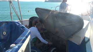
The Buccaneer Archipelago of Western Australia These are a group of islands off the Western Australia coast. The nearest town is Derby. The closest inhabited place is Bardi. An aboriginal settlement about fifty kilometres away on the coast. The Archipelago is over fifty square kilometres (19 sq. mi) in size. Composed of about eight hundred islands found between King Sound and Collier Bay. Close to Yampi Sound. Huge Tidal Range in the Kimberley Islands The area where our adventure unfolded boasts remarkable tidal ranges, with the water level fluctuating by over ten metres. This unique natural phenomenon sets the stage for the maritime activities that take place in these waters. During the beginning of our journey, two members of our newly acquainted crew were engrossed in the arduous task of hoisting up the ship anchor. The atmosphere was filled with the resounding noise of the heavy chain being retracted, link by link, as it emerged from the depths below. Meanwhile, one of the two crew members ensuring the smooth and efficient operation of this crucial process. Diligently sprayed the chain with a water hose, adding a touch of fluidity to the otherwise mechanical task. Amidst this bustling scene, Skipper Steve 'Tux' commanded the wheelhouse of the MV Oceanic with unwavering focus and determination. His presence was a testament to the dedication and responsibility that comes with steering a vessel through challenging waters. It was evident that his time was not solely dedicated to leisurely activities such as light reading in the captain's chair; rather, his role demanded constant vigilance and quick decision-making. As the ship's engine hummed in the background, a subtle reminder of the power that lay beneath the surface, our belongings were neatly stowed away. Swags, pre-rolled and strategically placed on the roof of the wheelhouse, symbolised our readiness to embark on the next leg of our journey. The anticipation of departure hung in the air, mirroring the ebb and flow of the tides that defined this remarkable maritime environment. Traveldriven CRUISE KIMBERLEY ISLANDS BUCCANEER ARCHIPELAGO CREW PULLING UP ANCHOR CAPTAIN STEVE HARD AT WORK ROLLING UP THE SWAGS SHIPMATES TAKING IT EASY ROLLED UP SWAGS ON ROOF ITEMS DRYING ON SIDE RAILING WATCHING A TOUR SHIP MOTORING AWAY The MV Oceanic captain Steve, discussing the famous aviator pioneer Kingsford Smith and his Kimberley forced landing site. On 31 March 1929, enroute from Sydney to England, the Southern Cross aircraft with Kingsford Smith at the helm made an emergency landing on a mudflat near the mouth of the Glenelg River, in the Kimberley region of northern Western Australia. The Southern Cross was found and rescued after a fortnight's searching. Dubbed the 'Coffee Royal' incident after the brew of coffee and brandy which the crew had drunk while awaiting rescue. Traveldriven PREV KIMBERLEY ISLANDS NEXT
- MINYIP SHOW & SHINE
Minyip This is a small regional Victorian town in the Wimmera. Three hundred and twenty kilometres (199 mi) northwest of Melbourne. It is in the Shire of Yarriambiack Minyip has a resident population a little over five hundred. The name "Minyip" holds a significant historical and cultural meaning as it is believed to have originated from an Aboriginal term signifying "ashes" or "camping place". The choice of such a name suggests a deep-rooted relationship between the Aboriginal communities and the environment, highlighting the importance of ancestral lands and the practices associated with them. By delving into the origins of the name "Minyip", we are offered a window into the past, inviting us to appreciate the intricate layers of history, language, and culture that have shaped the identity of this place. Minyip was the location for the popular tv series, Flying Doctor's. The series was produced between 1986-92 in the tv country town of "Coopers Crossing". The Minyip Show & Shine has been held in November. For 2024 and 2025 it was held in February. Traveldriven DRIVE MELBOURNE TO MINYIP COOPERS CROSSING GARAGE & OPEN CAFE ACROSS THE ROAD The Shine & Shine was well attended by motorbike riders. Many rode well maintained older bikes from the pre 2000s. Motorbikes on the day were Japanese and USA manufactured. ANZAC SOLDIERS The above Harley Davidson image has a custom painted scene of ANZAC soldiers in single file with a setting golden sun. Spotlessly maintained and a nice saddle seat. SERVICE MEDALS Another image of the righthand side of the Harley Davidson. Note the five war service medals below the seat. A nice Honda 750 four is directly behind. Looks in good original condition. On the far right is a driveable Mad Max interceptor equipped with lights. As seen in the first movie. Old unused bowser pump. In front of a well frequented café in the main street. Mustang did not need fuel. MILLION DOLLAR BUGATTI This light blue Bugatti was said by the driver to be worth one million dollars. The driver not being the owner. He was employed to drive the car from Melbourne to Adelaide via Minyip. A breezy drive. The owner a city millionaire. BUGATTI DASH HANDDRAWN GEARSHIFT PATTERN Note the on dash handwritten gear shift pattern. There is a story there. Looks like a standard H pattern. Should be easy to remember. The speedo and tacho should swap positions. Not a full right hand drive conversion. Mileage of 45,000 km? on the dial. MAD MAX MFP CAR MINYIP SHOW & SHINE WALK PREV SHOW & SHINE NEXT HOMEPAGE
- HOT RODS IN THE GRAMPIANS SHOW & SHINE
Halls Gap in the Grampians and the annual Hot Rod Show and Shine, February. A weekend in Halls Gap. Halls Gap is a town in Victoria and surrounded by the Grampians National Park. The town is in Fyans Valley between two ranges. The Grampians National Park (Gariwerd), commonly referred to as 'The Grampians', is a national park located in Victoria. The 167,219-hectare (413,210-acre) national park is situated between Stawell and Horsham off of the Western Highway. About a twenty minute drive from Stawell the closest regional town. Halls Gap has a population of about four to five hundred. The drive from Melbourne takes about three hours, following the Western Highway and then taking a left turn off at Stawell onto Grampians Road for an additional 25 km. Traveldriven ROLLIN HOT RODS HOT RODS ARRIVAL IN HALLS GAP SKY BLUE HOT ROD UNDER THE TREES ROD RUN STICKER AND CAR ENTRANT 66 HOT RED ROD DARK BLUE AND WHITE TONE WHITE RIMMED TYRES NICE MATCHING RUNNING BOARD LARGE CHROME GRILLE BUICK 1956 ROADMASTER PARKED AND READY COPS ARE DISLLUSIONED, TIRED, JADED AND FADED *STATE TROOPER* OLD SKOOL ROD REAR TYRES EXTEND FAR OUT FROM BODYWORK READY TO RUMBLE Row of hot rods Yellow hot rod suicide doors Hot pink hot rod and trailer Bright green Ford & motorsport rocker cover triple wipers Bright lime green hot rod with theme trailer and drive-in stand with side window food tray Red hot rod with rear suicide doors Red mustang with side vents mustang in neat and tidy trim Early model mustang interior left-hand drive PREV SHOW & SHINE NEXT HOMEPAGE