YOUR NEXT TRAVEL EXPERIENCE
Search Results
274 results found with an empty search
- STAY IN BROKEN HILL & SILVER CITY HIGHWAY
A group of feral goats crossed the highway fifty km from Wentworth. Also encounted were small swarms of locusts over the Silver City Highway. - Traveldriven Mildura A city with a population of over thirty-five thousand residents (2025) is inside the Victorian border and it is a distance of thirty km to the small town of Wentworth on the drive to Broken Hill in New South Wales. Mildura is a large fruit, grapevine and irrigation district. Broken Hill Is the only large mining city in the far west of outback New South Wales. Connected to Wentworth NSW by the fully sealed Silver City Highway and then onto Mildura in Victoria. Broken Hill's hot desert climate, combined with an average rainfall of 235 mm makes it a hard place to enjoy year round. Resident population is greater than 17,000. Many accommodation options are available. Broken Hill driving distance from Sydney is 1,150 km. If driving from Sydney, drive Sydney to Nygan where the Barrier Highway begins then onto Cobar, Wilcannia and Broken Hill. Driving distance from Melbourne 836 km. I was driving solo, a distance of almost 700 km from the Wimmera in Victoria. Silver City Highway The Silver City Highway connecting Broken Hill to Victoria is a fully sealed highway. Sections of road are unfenced with wandering livestock and wildlife. The area on occasion, may have severe weather of extreme heat or torrential rainstorms. Embarking on the Silver City Highway journey from the town of Wentworth, NSW, to the iconic destination of Broken Hill in a powerful mustang GT is an experience like no other. Covering a distance of 265 km, this road trip offers a blend of adventure, natural beauty, and unexpected encounters. As you cruise along the highway, the landscape transforms before your eyes, showcasing the diverse Australian outback scenery. Just fifty kilometres out from Wentworth, you might come across a group of feral goats leisurely crossing the road, adding a touch of rural driver beware of wildlife to your drive. The presence of small swarms of locusts hovering over the road creates a surreal sight, reminding you of the delicate balance of nature in this vast land. Amidst the vast expanse of the outback, you may encounter wandering sheep and horses, a testament to the agricultural heritage of the region. The occasional sighting of kangaroos hopping across the horizon, and hopefully not across the road in front, adds a touch of wildlife to your journey, highlighting the unique fauna that call this area home. Each passing kilometre on the Silver City Highway is a testament to the untamed beauty of the Australian outback, offering a glimpse into a world where nature reigns supreme and surprises await at every turn. From unexpected encounters with local wildlife to the ever-changing landscape, this road trip in a mustang GT is a memorable adventure that captures the essence of the Australian outback in all its glory. Coombah Roadhouse. The only service stop between Wentworth and Broken Hill is often closed. Understood to be closed into 2025 with no reopen date advertised. If open, diesel and 91 octane petrol available only. Road trains do operate on the Silver City Highway. It's a distance of 265 km or three hours' drive between Wentworth and Broken Hill with no fuel or food services available. Menindee Lakes The small settlement of Menindee is one hundred and ten km from Broken Hill along the fully sealed Menindee Road. Menindee Road joins the area known as Sunset Strip. The Sunset Strip follows the edge of Menindee Lake which is a very large lake by surface area and is the largest lake of four main lakes in the group. Many dead trees stand in the lake. A number of holiday shacks or older style homes line Sunset Strip. Residents of Broken Hill use the lakes for watersport recreational activities. Very often the lakes have little or no water being in a desert environment. Droughts are common. Sunset Strip appears to have very few people seen going about daily activities as does Menindee. Very limited or non-existent retail services are available. Kinchega Woolshed is available for the general public to inspect. A short drive less than ten km on unsealed roads from the Menindee lakes. The woolshed was one of the largest in New South Wales in its heyday. Now a historic relic of the past. Shearers were employed by the owners of the now ruined Kinchega Homestead. Traveldriven MILDURA VICTORIA GOOGLE MAPS BROKEN HILL GOOGLE MAPS MENINDEE LAKES GOOGLE MAPS BROKEN HILL CURRENT FIVE DAY WEATHER FORECAST DRIVE MILDURA TO BROKEN HILL WAYSIDE REST BREAK BESIDE THE MURRY RIVER BETWEEN MILDURA & WENTWORTH BIG LIZZIE RED CLIFFS 'BIG LIZZIE' THE WORLD'S LARGEST TRACTOR LOAD CAPACITY 80 TONS BUILT 1915. USEAGE WAS TO CLEAR BUSH FOR FARMLAND. COOMBAH ROADHOUSE CLOSED NO SERVICES (2022\2026?) COOMBAH ROADHOUSE CLOSED UNTIL FURTHER NOTICE ENTRY SIGN SILVER CITY HIGHWAY LINE OF LODE MINERS MEMORIAL TOP LEFT THE BIG BENCH Line of Lode Road VIEW OF BROKEN HILL FROM THE BIG BENCH ON THE BANKS OF THE DARLING RIVER NEAR MENINDEE NSW 110 KM FROM BROKEN HILL ALONG THE FULLY SEALED MENINDEE ROAD OUTBACK HISTORIC WOOLSHED KINCHEGA, NEAR MENINDEE NSW PREV NSW NEXT HOMEPAGE
- SILVERTON & OUTBACK PUBS NEW SOUTH WALES
Green grass is rarer than gold in Silverton. -Traveldriven Silverton The town is a famous Australian outback destination. Known for its outback scenery and locations for movie sets. Population is about fifty residents. Silverton is twenty-six kilometres north-west of Broken Hill on a sealed road. Broken Hill is a little over 1,100 km west of Sydney and 850 km north of Melbourne. The town was established after the discovery of rich silver deposits. These deposits later diminished out. Silverton is often referred to as a ghost town and is often frequented by day trip tourists in the cooler winter months. As of 2026 Silverton has: One working hotel with film memorabilia One modern bakery. One church Mad Max 2 Museum. Working Artist Gallery. Caravan/camping area with an amenities block. There are some derelict old dwellings about the town and some scattered housing. A historic jail with-out-buildings now used as a museum. The main street has several closed public buildings dating back pre-1900. Large tourist buses do frequent the town. Almost all the town roads are unpaved but these are still good for all types of vehicles. A shallow creek crossing with a concrete base must be driven over to enter the town. The creek named Mindioomballa Creek seldom flows water. The creek is only a concern if very recent rare torrential rainstorms have passed through. The creek crossing is about six hundred metres from the hotel. Silverton Hotel The original hotel opened in 1884 and was replaced a year later by a two-story building. This burnt down in 1918. Ruins of the burnt hotel are preserved to this day. The ruins are at the rear of the current hotel in a green grassed courtyard. On the other side of the courtyard are hotel accommodation units. Green grass is rarer than gold in Silverton. The hotel is open daily for patrons and meals may be ordered and eaten in the large adjoining and covered seating area (beer garden). Film memorabilia cover the interior walls of the hotel. As well as the Mad Max ll film, numerous big budget movies have been filmed in and around the Silverton area. Traveldriven ENTER CLICK/TAP SILVERTON GOOGLE MAPS BROKEN HILL GOOGLE MAPS DRIVE MILDURA TO BROKEN HILL Bullet riddled road sign on the Silver City Highway between Mildura and Broken Hill PIG MELONS? SILVER CITY HIGHWAY Silverton Hotel with replica Mad Max car. Photo taken 2008 GREEN GRASS IS RARER THAN GOLD IN SILVERTON self-contained accommodation is rear of hotel opposite the ruins and green lawn. RUINS OF BURNED OUT SILVERTON HOTEL THE SILVERTON HOTEL OUTBACK PUBS Silverton landscape Silverton scooter PREV NSW NEXT
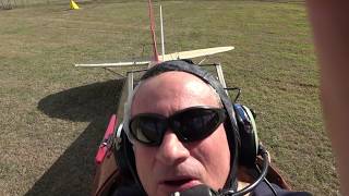
- TIGER MOTH FORCED LANDING MACKAY & GLADSTONE QUEENSLAND
ENGINE EXPLODED. EIGHT HUNDRED FEET UP "MAYDAY MAYDAY MAYDAY" -Max the pilot GLADSTONE A Queensland coastal city 517 km north of the state capital Brisbane. Urban population is greater than 45,000. Approaching Gladstone by road the city is dominated by a power station. This gives the city a real industrial look. Gladstone is home to the retired patrol boat HMAS Gladstone. The ship is in dock on public display in the Port of Gladstone. Overnight motel accommodation was in Gladstone CBD off Goondoon Street. MACKAY The city is almost one thousand kilometres (600 mi) north of Brisbane, on the Pioneer River. Population is greater than eighty thousand. Mackay is nicknamed the sugar capital of Australia because its region produces more than a third of Australia's sugar. Two nights were spent in Mackay. Accommodation was at Rydges Motel. Time allowed for a cool swim in the refreshing water of the local Bluewater Lagoon. These are three tiered lagoons in Mackay’s city centre. A safe stinger-free swimming environment. Great place to cool off and relax. Family friendly and free admission. There is a waterfall and water slide connecting the lagoons. Café and BBQ facilities are onsite. GLADSTONE GOOGLE MAPS MACKAY GOOGLE MAPS MACKAY BLUE WATER LAGOON TIGER MOTH MUSEUM JOY FLIGHTS While in the tropical coastal city of Mackay I chose to take a flight in a Tiger Moth. I noticed flights advertised on a billboard near the Mackay Airport, and since it was something I had always considered doing, I booked a half-hour joy flight from there. When I paid for the flight, staff assured me all their aircraft were certified and that both their planes and pilots had maintained a spotless safety record over decades of flying operations. With the pilot seated in the rear seat, and me in the front, our Tiger Moth had just flown over an extensive mangrove area returning to the airport on the city fringe. Mangroves are a known habitat for saltwater crocodiles. A loud bang was heard and a football size ball of black smoke rose above the engine. Our lone spinning propeller stopped dead. The engine fell silent. Max the pilot radioed and called a “Mayday, Mayday, Mayday”. Three Mayday calls are a general emergency distress call to all aircraft and air traffic control in the vicinity. For us, this meant southern Queensland. Max was a pilot with fifty years of flight experience and approaching retirement. Max radioed over the intercom. "Will put her down below on the right". I looked to the right. I could see small gravel roads and cane fields far below. I gripped the side of the open cockpit and braced my feet for impact. I stayed silent. Best to let Max do his job. I was glad of the tight seatbelt harness. Before the flight there was a routine mandatory pre-flight safety briefing. In the event of an unlikely emergency pull the intercom cable out from the airframe panel to cleanly escape a water ditching. We weren't over water anymore. Tiger Moth Forced Landing Looking forward and eyes wide open I wanted to be aware of the surroundings when we touched the ground. I wondered if Max had suffered a medical episode. I'm an unfortunate victim and wondering now how I will survive. We banked right, glided above an unfinished overpass, and in a straight line touched down and rolled to a stop. Unpowered flight time to touch down on the unsealed road was five minutes thirty seconds. My video camera is still rolling and out of focus capturing thin air and audio of rushing wind. I was more concerned with bracing for the expected hard landing. I was thinking for the previous five minutes we could get seriously injured or worse. No panic, more of a calm foreboding feeling until touch down. Road workers ran to us from everywhere. Eager to see if we were ok. A supervisor quipped “you can't land here”. Max replied we had no choice. Even though the airport was five minutes flight away we wouldn't have made the runway. Engine oil was splattered throughout. Max radioed be careful getting out over the aircraft wing as the oil would be very slippery. All emergency services were called and arrived on the scene some 45 minutes later. All arriving together. Fire truck, ambulance, police and Mackay Airport authorities. Upon inspection, Max thought the crankshaft had broken in mid-flight causing the plane to come down. Perhaps requiring $70,000 in repairs. We all milled around the front of the aircraft and Max jokingly said, 'You Victorian's come up here to holiday and we nearly kill you'. ‘First prang in fifty-one years’, Max commented. Emergency personnel offered me a return to the ambulance station for observation as Max and I had been through a near death experience. No thanks. It gave us a fright, but all is ok. After about an hour of aircraft checks and questions, emergency personnel returned me to Mackay Airport. I carefully drove to my accommodation where I stayed for the remainder of the day. I had no one to confide in as this was a solo three week road trip. I did not ask for a $200 flight refund. As I thought the money was well spent to get out in one piece. Next morning I drove on to Bowen. Almost 200 km and a two hour drive. The plane incident was easily put behind me. Technically a forced landing. However, at the time I thought a crash was the likely outcome. Well done to Max the pilot. In reality he saved both our lives insuring no injuries. BURIED IN THE FINE PRINT The Civil Aviation Safety Authority (CASA) states this is a Warbird and operated in the LIMITED category, passengers must understand that: The design, manufacture and airworthiness of the aircraft are not required to meet any safety standard recognised by CASA CASA does not require this aircraft to be operated to the same degree of safety as an aircraft on a commercial passenger flight. The passenger flies in the aircraft at his or her own risk In undertaking this Adventure Flight I accept the potential risks The Mackay Ring Road is a bypass route near Mackay, Queensland, Australia. Stage 1 completion was 2020. Stage 1 is 11.34 km in length and connects the Bruce Highway to the south of Mackay (at Stockroute Road) with the Bruce Highway to the north of Mackay (near Bald Hill Road). The bypass involved constructing a new bridge over the Pioneer River and an interchange with the Peak Downs Highway. MACKAY RING ROAD STAGE ONE Tiger Moth joy flight and crash (forced landing) at the time of the still under construction, Ring Road Stage 1, Mackay Queensland. TIGER MOTH FORCED LANDING ON RING ROAD EARLY MORNING BEFORE THE FLIGHT ALL GOOD TO GO THE OTHER TIGER MOTH IN PERFECT WORKING ORDER MACKAY AIRPORT HMAS GLADSTONE SHIP'S BELL HMAS GLADSTONE SHOWN AROUND ON PRIVATE TOUR PREV ROADTRIP TOWNSVILLE NEXT PREV QUEENSLAND NEXT HOMEPAGE
- IVIG 'ON THE DRIP' What it all means with CIDP
Intravenous Immunoglobulin (IVIG) for CIDP (IVIG) is a solution of human plasma proteins and in particular IgG antibodies with a broad spectrum of antibody activity. IVIG is prepared from large pools of human plasma collected from several thousand blood donors and contains the typical IgG antibodies found in the normal population. Recipients of intravenous immunoglobulin (IVIG) therapy often find themselves on a long-term treatment regimen, sometimes requiring these infusions for the entirety of their lives. This is particularly true for individuals suffering from chronic autoimmune conditions, immunodeficiencies, or certain neurological disorders, where the immune system's functionality is compromised or needs modulation. The administration of IVIG plays a crucial role in providing the necessary antibodies that the body may be lacking, thus helping to bolster the immune response and protect against infections. PATIENT IMPROVEMENT In some cases, patients may experience significant improvement in their condition due to the IVIG treatments. As a result, they may recover sufficiently to be considered for a reduction or even cessation of their IVIG therapy. This recovery can be attributed to various factors, including the body's adaptive response to the treatment, changes in disease progression, or the implementation of additional supportive therapies that enhance overall health and immune function. Such patients may undergo rigorous evaluations and assessments to determine their eligibility for discontinuation of IVIG, which can be a hopeful milestone in their treatment journey. However, the treatment landscape for IVIG recipients is not always straightforward. Some individuals who initially qualify for IVIG therapy may, over time, find that their condition evolves or changes in a way that necessitates a shift in their treatment approach. This could be due to a variety of reasons, including the emergence of new symptoms, the development of complications, or the realisation that the current treatment is no longer effective. In such instances, healthcare providers may explore alternative treatment modalities, which could include other immunotherapies, corticosteroids, or even more novel approaches like biologic agents that target specific pathways in the immune system. The journey of an IVIG recipient is often characterised by ongoing monitoring and adjustments to their treatment plan, reflecting the dynamic nature of their health status. Each patient's experience is unique, shaped by their specific medical history, response to therapy, and the evolving understanding of their underlying condition. As a result, the management of patients receiving IVIG is a collaborative effort between healthcare providers and patients, aimed at optimizing treatment outcomes and improving quality of life. IVIG DAY ONE & DAY TWO COMPLETED OVER TWO DAYS IVIG TREATMENT INITIALLY GIVEN ON TWO CONSECUTIVE DAYS EACH MONTH LATER EVERY SIX WEEKS THEN EVERY EIGHT WEEKS IVIG INFUSION ROOM COMFORTABLE INFUSION CHAIR (NOT THE ELECTRIC CHAIR LOL) IVIG INFUSION VIEW INFUSION CENTRE CHRISTMAS TREE IMMUNOGLOBULIN INFUSIONS SCIg self-administered IVIG INTRAVENOUS IMMUNE GLOBULIN (IVIG) WHAT IS IVIG? PREV CIDP NEXT HOMEPAGE
- STAY AT ORMISTON GORGE IN CENTRAL AUSTRALIA
Ormiston Gorge The gorge is situated approximately 135 kilometres to the west of Alice Springs, a central hub in Australia’s Northern Territory. Visitors can easily access this stunning natural wonder by travelling along the well-maintained and fully sealed roads known as Larapinta Drive, Namatjira Drive and Ormiston Gorge Access road. These scenic routes offer breathtaking views of the rugged Australian landscape, making the trip an unforgettable experience. Upon arrival at Ormiston Gorge, one will discover a permanent deep waterhole, a remarkable feature of the gorge that draws both locals and tourists alike. The water in this waterhole is notably cold, a refreshing contrast to the often warm and arid climate of the region, and while swimming is permitted, it is advisable for swimmers to be prepared for the brisk temperature. In addition to the natural beauty of the gorge, there are camping facilities available for those wishing to immerse themselves in the great outdoors. These facilities provide a comfortable base for exploration and relaxation, allowing visitors to fully appreciate the serene environment. Be aware wild dingo dogs are ever present and are often not seen. Dingo's will seek out food scraps and pull apart plastic bags if left outdoors unattended. It is important to note that camping fees apply for those who wish to stay overnight, and these fees can be conveniently paid online in advance. Furthermore, a park entry fee is also required, which must be settled for the specific date of intended arrival, ensuring that the park can be maintained and preserved for future generations to enjoy. BUSH ARTISTS On this particular occasion, two talented bush artists had gathered beside the riverside gums, passionately engaged in the art of painting landscapes that captured the essence of the breathtaking surroundings. With brushes held firmly in gloved hands and donning flynet hats to protect themselves from the persistent flies, they busily worked on their canvases, each stroke reflecting their unique interpretation of the picturesque vista before them. These artists were not only creating beautiful artworks but were also eager to share their creative process and the inspiration behind their pieces with curious onlookers. As visitors approached, they were met with enthusiastic explanations and insights, allowing for a deeper appreciation of the art as well as the natural beauty that inspired it. This interaction between the artists and the public fostered a sense of community and connection, highlighting the importance of art in capturing and celebrating the natural world. Traveldriven DRIVE STANLEY CHASM - ORMISTON GORGE TWO BUSH ARTISTS LEFT HAND ON THE JOB GETTING IT RIGHT ORMISTON GORGE PAINTING THE LANDSCAPE GETTING IT RIGHT READY FOR A SWIM? RIVERSIDE GUM PREV AUSTRALIA 2025 NEXT
- WALK STANDLEY CHASM OF THE WEST MACDONNELL RANGES
Standley Chasm Known as Angkerle Atwatye in the local Arrernte language, the chasm is a stunning natural wonder situated approximately fifty kilometres west of Alice Springs, a central hub in the heart of Australia’s Northern Territory. This remarkable geological formation is nestled within the rugged landscape of the West MacDonnell Ranges and is an essential part of the region's cultural and natural heritage. The chasm itself is located on privately owned Aboriginal land, which adds a layer of significance and respect for the traditional custodians of the area. Accessing Standley Chasm is convenient, as it lies just off the well-maintained, all-sealed Larapinta Drive, a scenic route that showcases the breathtaking beauty of the surrounding terrain. Visitors to Standley Chasm can expect a short yet picturesque drive of approximately ten minutes off of Larapinta Drive along a sealed road that leads directly to the entrance. This accessibility makes it a popular destination for both tourists and locals seeking to explore the unique landscapes of the Australian outback. As of 2025, there is a general admission fee of $12 per person, which contributes to the maintenance and preservation of this beautiful site, ensuring that future generations can enjoy its splendour. CAFE AND CAMPING Upon arrival, guests will find a well-equipped on-site café, which offers a variety of refreshments and meals, making it a perfect spot to relax and soak in the stunning views of the chasm before or after their exploration. The café serves as a convenient gathering place for visitors to share their experiences and enjoy the local ambiance. The main Standley Chasm walk begins to the right of the cafe and is relatively flat. The walk follows alongside a creek and takes about twenty to thirty minutes. Sturdy footwear is best for the stoney areas walked upon. For those looking to extend their stay, Standley Chasm also features a camping area suitable for all types of vans. The ground is rocky and hard. Pitching a tent may be difficult. This camping area provides a unique opportunity to immerse oneself in the natural surroundings, with the sounds of the outback and the starry skies of the desert at night offering a truly memorable experience. However, it is important to note that the ground in the camping area is quite hard, with no grassy sites available, and overnight temperatures may be quite low which may require campers to bring appropriate sleeping gear for comfort. Overall, Standley Chasm is not just a visual marvel; it is a place where nature, culture, and adventure converge, making it an essential stop for anyone travelling through the Northern Territory. For an insight into Alice Springs go to an earlier Road Trip WA/NT/SA post. Traveldriven DRIVE ALICE SPRINGS - STANDLEY CHASM STANDLEY CHASM SIGNAGE INSIDE THE CHASM FAR END OF THE CHASM COLD POOL OF WATER AND ROCKY BLOCKAGE COLD WATER GHOSTLY ROCK PREV AUSTRALIA 2025 NEXT
- KAKADU NATIONAL PARK & JUMPING CROCS
Kakadu National Park The park is within the Alligator Rivers area of the Northern Territory. Kakadu covers an area almost two hundred kilometres (120 mi) from north/south and over one hundred kilometres (62 mi) from east/west. Kakadu Highway The fully sealed highway starts at Pine Creek and finishes at Jabiru. If driving from South Australia, follow the highway from Pine Creek turnoff to Jabiru a road distance of 213 km on an all sealed road and then follow the all sealed Arnhem Highway to Darwin. Darwin to Kakadu The park entrance is an easy two-and-a-half-hour drive. Distance of 210km. Along the fully sealed Arnhem Highway . On park entry, an entrance fee applies. A Kakadu Yellow Water Cruise is essential. Up to two hours, observing flora and fauna. Crocodiles and birdlife. The township of Jabiru offers tourist facilities and services. The Adelaide River Jumping Crocodile Cruise is a short river tour on the drive to Kakadu from Darwin and before Jabiru. Cahills Crossing Cahills Crossing in Kakadu National Park is about forty km further from Jabiru and also reached on a sealed road. The crossing has witnessed at least two fatal crocodile attacks. Located on the East Alligator River. One of these, a fisherman knee deep at the water's edge. Another attack killed a male walking the crossing. Widely regarded as the most dangerous river crossing in Australia. Abandoned vehicles washed into the river can often be seen. Crocodiles gather to eat fish in the murky water. Dozens of large crocs inhabit the immediate area. Safe Crocodile Viewing and Obey the Warning Signs A safe river viewing platform overlooks the East Alligator River and is off to the right side of Cahills Road river crossing. There is also a viewing area to the left of the crossing. These are safe areas to view saltwater crocodiles in the wild outside of an organised tour. Safe for families. It's not uncommon to view multiple numbers of crocodiles from the public viewing platform. Most are in the river. A few are perhaps out of the water on the edge of the crossing. Do not cross the river into Arnhem Land without a permit. Even on the low tide when the crossing may be dry. It's still unsafe to do so. Alligator River is a misnomer. Early pioneers thought the crocodiles were alligators and so named the local rivers East and South Alligator. Merl Campground Located next to the East Alligator River is the Merl Campground, where a small camping fee is required on arrival. Cahills Crossing is a short walk from this bush campground. Upon arrival, campers can choose from any of the designated camping areas that are empty. All of which offers shade and privacy thanks to the lush foliage from the nearby river. The campground has no power, and the facilities are basic. Merl Campground accommodates all types of road-going vehicles. Be aware the campground often experiences swarms of biting mosquitoes after dark, and the river should be avoided due to the presence of saltwater crocodiles. The Ubirr rock art site is three kilometres away. Border Store The Border Store renamed Manbiyarra is near Cahills Crossing viewing platform and was a general store. The store changed ownership and renovations were done in 2025 with a tourist focus on local indigenous art. Manbiyarra Border Store is open in the dry season May to October. Yellow Water In Kakadu National Park there is Yellow Water Billabong. The billabong has a countless variety of birdlife such as jabiru and whistling ducks. Saltwater crocodiles are common and water buffalo may be seen. Colourful water lily's stretch as far as the eye can see. Yellow Water two-hour boat cruises are very popular and operate daily. Pine Creek A short practical hire\drive driving itinerary in the vast distances of the Northern Territory is for a loop drive route Darwin, Kakadu, Pine Creek and return to Darwin. All on sealed roads. Pine Creek is two hundred and twenty-five km from Darwin. To follow the suggested driving loop at least one overnight stay is required to allow an adequate time for tours and see the sights. Two nights even better. Accommodation is available in Jabiru and Pine Creek. For more Kakadu information also read Darwin post . Read Pine Creek post for overnight accommodation and sights. Traveldriven ENTER CLICK/TAP KAKADU/JABIRU GOOGLE MAPS IN REALTIME DRIVE DARWIN TO KAKADU -PINE CREEK & RETURN JUMPING CROCODILE TOUR BOAT JUMPING CROCS ADELAIDE RIVER Jumping Crocodile Cruise ADELAIDE RIVER Molly's Kakadu roadtrip. Showcases indigenous rock art which I believe is refreshed regularly by local indigenous people. A traditional practice going back thousands of years to keep living culture alive. Jim Jim Falls may disappoint in the later dry season. Expect dry waterfalls and rough unsealed roads to Jim Jim and Twin Falls. Thankyou to Molly Dixon Youtube for enabling video sharing. Always high-quality content by an Australian prepared to go drive and see Australia. Traveldriven UBIRR ROCK ART, KAKADU EASILY ACCESSIBLE BY 2WD KAKADU SIGN KAKADU WILDLIFE ABANDONED IN THE SCRUB DERELICT AIRPLANE AT REST SEALED ROAD TO JABIRU TOWN JABIRU TOWN BAKERY (now closed) YELLOW WATER CRUISE CAMERAS AT THE READY CROC SPOTTING INJURED SALTWATER CROCODILE IN THE SUN SWIMIMING CROCODILE YELLOW WATER JABIRU YELLOW WATER BIRDLIFE SIGNAGE CAHILLS CROSSING CAHILLS CROSSING HIGH TIDE CROCODILE WARNING SIGNAGE KINGA CROCODILE DRIVE CAHILLS CROSSING DRIVING CAHILLS CROSSING PREV AUSTRALIA ICONS NEXT PREV N\ TERRITORY NEXT HOMEPAGE
- THE TWELVE APOSTLES, GIBSON STEPS & THE BLOWHOLE
The Twelve Apostles over time dwindle in number. Due to wind, rain and waves. Recent collapses have occurred. THE TWELVE APOSTLES These are a collection of limestone stacks off the shore of Port Campbell National Park, by the Great Ocean Road in Victoria, Australia. The Twelve Apostles and the extended viewing platform and walkways are one of the most visited places in Australia. There are five sea stacks in close proximity to one another and these may be seen from the official Twelve Apostles viewpoints. An additional sea stack collapsed in July 2005. If not self-driving full day bus tours are available from tour operators based in Melbourne. For a reference, bus tour pricing per adult is from ninety-five Australian dollars as of 2026. TWELVE APOSTLES & VIEWING AREA'S Travelling from Melbourne to The Twelve Apostles via the Princes Highway is about 225 km and takes nearly three hours by car. The most scenic route is through the coastal towns of Lorne and Apollo Bay along the Great Ocean Road, and takes about four hours to drive the 300 km from Melbourne. Seven of the original limestone stacks remain. The official viewpoint has a large bitumen surfaced parking area for cars and buses on the landward side of the Great Ocean Road. The area is extremely busy in peak periods. There are both a Tourist Information building combined with a café onsite. The building has toilets for visitors. There are plans for further expansion. The Twelve Apostles official viewing areas and other sites are completely free to attend as of early 2026. WALKING TRACK TO THE TWELVE APOSTLES The Twelve Apostles walking track is accessed behind the café. This well maintained and surfaced pathway passes underneath the Great Ocean Road which is the only point offering shade from a hot sun or protection from rain along the entire walkway. Viewing lookouts are a fifteen-minute walk further along. One way. A wide and flat pathway leads to the viewing areas. The expanded Saddle Lookout viewing platform built in 2023 at a cost of nine million dollars does not extend over water or cliffs. However, there is slight platform movement felt underfoot when standing towards the seaward end. Scenic helicopter flights are available from the Twelve Apostles in peak periods. These flights are taken from behind the Twelve Apostles vehicle parking areas. WILDLIFE DANGERS OF THE TWELVE APOSTLES Dependant on time of year tourists may be bothered by persistent flies. Also, in the warm summer months and often at peak visitation times, numbers of tiny nipping insects may be encountered. If wearing lightly coloured clothing such as a white t-shirt or polo top these tiny insects can be seen in large numbers appearing as a small dark\green pinhead on clothing. These insects are often referred to as Midges. There are warning signs indicating venomous snakes may be sighted along the Twelve Apostles pathway. Experience suggests people would be unlucky to venture across a snake on the actual walkways. Still the risk is present. The main walkway is very wide so anything crossing can be easily bypassed. Koala, kangaroo and birds of prey are generally never seen in the vicinity of the Twelve Apostles. These animals may be seen at various points along the Great Ocean Road. SADDLE LOOKOUT TWELVE APOSTLES ONE OF TWO WALKWAYS BETWEEN OLD LOOKOUT & NEW SADDLE LOOKOUT SADDLE LOOKOUT TWELVE APOSTLES LOCH ARD GORGE From the Twelve Apostles and driving towards Port Campbell, it's a short distance of a few kilometres to Loch Ard Gorge. Loch Ard Gorge and the short walks offering coastal views, (such as The Razorback) of cliffs and ocean is a very popular tourist spot. Above Loch Ard Gorge a stairway allows visitor access to a small sandy beach surrounded by vertical limestone cliffs on all sides via an opening to the sea. Loch Ard Gorge itself is the 1878 historical site of two shipwreck survivors. NEAR BY TO THE TWELVE APOSTLES AND LOCH ARD GORGE WALK THE RAZORBACK THE BLOWHOLE The Blowhole carpark and walkway is within one hundred metres of the larger Loch Ard Gorge carpark. From The Blowhole parking area, it is an easy five minute walk to the blowhole viewing platform. Even during peak tourist visitation times for the nearby Twelve Apostles, The Blowhole may experience few tourists. During 2025 The Blowhole viewing area was greatly expanded with a cost of more than six million dollars. Enabling visitors to experience up close and in complete safety the force of nature with foaming sea, sea spray and mist forced high into the air accompanied by a thundering roar. The blowhole viewing platform and structure partially encloses this open blowhole that is permanently filled with deep turbulent seawater. The actual blowhole is a circular rock structure perhaps thirty or so metres across with open seawater funnelled underneath large coastal rocky ground overhead. The entrance to the blowhole on the seaward side looks like a massive, sea-flooded cave. Seawater surges through to the large blowhole and retreats. Best viewed when the ocean is stormy or rough. On the rare days when the ocean is calm and there's minimal ocean swell; the impact on one's senses is negligible. The Blowhole enclosure can cater to large visitation numbers and gives protection from rain and sun. THE BLOWHOLE PLATFORM SHAPED LIKE A BREAKING WAVE THE BLOWHOLE & CAVE THE BLOWHOLE & CALM SEAS PORT CAMPBELL The popular small seaside town of Port Campbell is about a ten minute drive from the Twelve Apostles. There is a swimming beach naturally shielded from rough surf, along with a fishing and boating jetty, various types of accommodations, and some retail options. PORT CAMPBELL BEACH GIBSON STEPS A few minutes drive away, almost within viewing distance of the Twelve Apostles, nestled along the picturesque Great Ocean Road on the way to Apollo Bay, you will discover the breathtaking Gibson Steps. These steps, meticulously carved into the rugged cliffside, provide visitors with a unique opportunity to descend to the pristine beach below, offering a close encounter with the raw beauty of the coastline. As you navigate your way down the Gibson Steps from the clifftop carpark, numbering near the hundred, the sheer magnitude of the towering cliffs above and the vast expanse of the Southern Ocean stretching out before you create a truly awe-inspiring experience. It is important to note that while the Gibson Steps offer a remarkable vantage point to witness the power of nature, swimming in the waters here is not recommended. The area is known for its strong rips and rough waters, making it unsafe for swimming. However, the dramatic scenery, the sound of waves crashing on the beach, and the feeling of standing at the intersection of land and sea make the Gibson Steps a must-visit destination for nature enthusiasts and photographers alike. Take a moment to breathe in the salty air, feel the cool ocean breeze on your skin, and marvel at the ancient geological formations that have been shaped by the elements over millions of years. A few of the Twelve Apostles may be viewed from the beach. There is also a longer walking track beginning from the Twelve Apostles. Whether you are a seasoned traveller or a first-time visitor to this stunning region, the Gibson Steps offer a glimpse into the untamed beauty of Australia's southern coast. So, take your time to explore, immerse yourself in the natural wonders that surround you, and create memories that will last a lifetime in this captivating coastal paradise. Attempting the Gibson Steps Mobility issues & gradual improvement Twelve Apostles and Philip Island Tourists often would like to drive Philip Island to Twelve Apostles or vice versa. Underestimating the distance of more than 400 km and six hours with no stops via Melbourne. A more realistic time is at least seven to eight hours. Alternate route of a Port Philip Bay car ferry crossing is perhaps more enjoyable and feasible. Via the Queenscliff\Sorrento car ferry. Traveldriven DRIVE TWELVE APOSTLES - PHILLIP ISLAND ENTER CLICK/TAP TWELVE APOSTLES GOOGLE MAPS SEAROAD FERRIES Queenscliff\Sorrento car ferry TWELVE APOSTLES VIEW TWELVE APOSTLES LOOKOUT VIEW TWELVE APOSTLES TWO LIMESTONE SEA STACKS SADDLE LOOKOUT REMAINING SEA STACKS OF THE TWELVE APOSTLES PREV AUSTRALIA ICONS NEXT HOMEPAGE POST
- BONDI BEACH CURRENT TEMPERATURE & FIVE DAY WEATHER
Bondi Beach Bondi Beach is a famous beach and takes it's name from the surrounding suburb in Sydney, New South Wales. Bondi Beach is about seven km (4 mi) east of Sydney central business district and can be easily visited on public transport. Bondi Beach is one of the most visited tourist sites in Australia throughout twelve months of the year. Bondi Beach is a world-renowned destination that attracts visitors from all corners of the globe. Its iconic crescent shape, golden sands, and crystal-clear waters make it a must-visit spot for tourists seeking sun, surf, and relaxation. The beach is not only popular during the summer months but also sees a steady stream of visitors throughout the entire year. Aside from its natural beauty, Bondi Beach offers a vibrant atmosphere with a bustling promenade lined with trendy cafes, surf shops, and art galleries. Visitors can soak up the sun, swim in the ocean, or try their hand at surfing in the famous waves of Bondi. The beach also hosts various events and festivals, adding to its allure and making it a hub of activity and entertainment. Moreover, Bondi Beach is not just a tourist hotspot but also a cultural melting pot, attracting people from diverse backgrounds and nationalities. This diversity adds to the unique charm of the beach, creating a welcoming and inclusive environment for all who visit. In mid-December of 2025 most people would be aware of the mass shooting that took place on a Jewish Community celebration by one thousand people gathered on Bondi Beach. There were sixteen deaths and 40 injured. It must be said that Bondi Beach is, apart from this one occurrence, a very safe area. General crime rates have decreased over the last ten years. The beach and surrounds can be enjoyed safely and there are regular beach patrols by lifeguards and normal police foot patrols. How to Travel Down Under to Bondi Beach Circular Quay waterfront Sydney CBD is the departure point to Bondi Beach and is under 10 km and approximately 25 minutes travel on the Watsons Bay ferry. Alternatively take a 40 minute bus trip. City2surf This is a 14 kilometre fun run course from Hyde Park, Sydney to Bondi Beach via Kings Cross. Usually held once a year in August. As a spectacle with 80,000 participants running and walking past, the event truly becomes a vibrant display of human spirit and determination. The sheer number of individuals coming together to challenge themselves physically and mentally creates an electrifying atmosphere filled with energy and excitement. Amidst the sea of participants, the novelty entrants stand out with their unique costumes and creative approaches to the race. These individuals not only bring a sense of humour and lightheartedness to the event but also showcase the diverse personalities and interests within the running community. Their presence adds an element of fun and entertainment, captivating onlookers and fellow participants alike. Each novelty entrant tells a story through their attire and demeanor, turning the event into a colorful tapestry of individuality and creativity. Their presence serves as a reminder that running is not just about competition but also about joy, camaraderie, and self-expression. The sight of these amusing novelty entrants further enriches the overall experience, leaving a lasting impression on all those fortunate enough to witness this extraordinary display of human ingenuity and passion. Traveldriven ENTER CLICK/TAP BONDI BEACH GOOGLE MAPS CIRCULAR QUAY GOOGLE MAPS CURRENT BONDI BEACH FIVE DAY FORECAST SYDNEY CBD TO BONDI BEACH GOOGLE MAPS catch a wave BONDI IN WINTER BONDI BEACH SAND BONDI BEACH WALK CITY 2 SURF FUN RUN PREV NSW NEXT PREV AUSTRALIA ICONS NEXT HOMEPAGE
- CAIRNS & GREEN ISLAND THE GREAT BARRIER REEF
Cairns Gateway to the Great Barrier Reef A tropical city in far North Queensland between the Coral Sea and the Great Dividing Range which extends as far south as Victoria. Cairns has only two seasons. Tropical wet and dry and the city may be affected by the wet season storms which are prone to develop into cyclones. Special Air Service Display Whilst in Cairns the Australian SAS conducted a display for WW2 veterans and the public on the foreshore. A pair of military Sikorsky Blackhawk helicopters flew low level along the coast to the foreshore and staged a mock rescue of a kidnapped person in a limousine. SAS armed with weapons firing blank rounds rappelled to the ground followed by extrication back to the helicopters. Enactment was very well done. Green Island The island is a coral cay twenty-seven km (17 mi) offshore from Cairns, Queensland within the Great Barrier Reef Marine Park. Green Island is made up of and is surrounded by coral reef. Most tourists are day visitors from Cairns. A forty-five-minute ferry ride from Cairns. A luxury resort is the only means of accommodation on the island. The small coral cay island is surrounded by coral reef ideal for snorkelling from the beach. An easy 45-minute rainforest walk encompasses the whole island. There is a swimming beach and also a crocodile park attraction. The only island accommodation is provided by Green Island Resort. On arrival at Green Island jetty, tourists may see the dark silhouettes of reef sharks circling below the boat. Reef sharks are considered fairly harmless if not encroached upon. Atherton Tableland Behind the city of Cairns and fifty km southwest is the Atherton Tableland plateau. The plateau is a part of the Great Dividing Range as previously mentioned that extends as far south as Victoria. There are a few lakes such as Lake Barrine fringed by thin bands of rainforest and some small villages. The plateau itself is not lush with rainforest, being more akin to resembling a farming landscape. Tours are available from Cairns. Traveldriven ENTER CLICK/TAP CAIRNS GOOGLE MAPS GREEN ISLAND GOOGLE MAPS CURRENT CAIRNS FIVE DAY FORECAST source Wix photo An introduction to Cairns and the surrounding area by Terry from the Youtube channel, Let's Go Many thanks to Terry for allowing sharing LAKE BARRINE INLAND FROM CAIRNS PREV BARRIER REEF NEXT PREV QUEENSLAND NEXT HOMEPAGE
- HOBART & CRAZY ARTWORK MONA TASMANIA
MONA TASMANIA Museum of Old and New Art. Visited February 2018 The Museum of Old and New Art (MONA) is an art museum within the Moorilla winery in Hobart, Tasmania. Apparently, it's the largest privately funded museum in the Southern Hemisphere. MONA houses old and modern art collected by David Walsh founder of MONA. Themes of sex and death. The museum is described by Walsh as a "subversive adult Disneyland". MONA was officially opened on 21 January 2011. MONA also hosts arts festivals which showcase public art and live performances. Salamanca Market Saturday morning is the famous Salamanca Market Day in Hobart's CBD. Great to wander around and look at the market stalls. I received a parking ticket on my car. Which I paid. Held since 1945 and starting on Boxing Day in Sydney. The Sydney to Hobart yacht race distance is approximately 630 nautical miles (1,170 km). Yacht crews celebrate on New Year’s Eve at Constitution Dock in Hobart. Traveldriven GOOGLE MAPS ENTER CLICK/TAP HOBART https://www.google.com/maps/place/Hobart+TAS ENTER CLICK/TAP MONA https://www.google.com/maps/place/MONA CURRENT HOBART FIVE DAY WEATHER FORECAST DRIVE FROM HOBART TO MONA TASMANIA Outside MONA Museum WEIRD CAR DESIGNS JUMP ON MY BONES MONA ART MOTIONLESS TATTOO MAN TATTOO ART MONA WRITING ON THE WALL SALAMANCA MARKET PREV PAGE NEXT HOMEPAGE
- CRADLE MOUNTAIN TASMANIA EASY WALKS
Cradle Mountain The mountain is in the Central Highlands region of Tasmania. Surrounded by the Cradle Mountain-Lake St Clair National Park. Rising to a height of 1,545 metres (5,069 ft) above sea level, Cradle Mountain is the sixth-highest mountain in Tasmania, Australia. The National Park is one of Australia's most popular to visit and is very well known for its hiking and stunning views. I drove daily from the town of Sheffield to Dove Lake car park Cradle Mountain in a Mustang GT. Spirited driving on the twisting roads. I don’t like heights but managed to hike Marions Lookout the highest point. Views are of Cradle Mountain, Dove Lake and other lakes. Dove Lake Boardwalk There is an easy walking track looping around Dove Lake. The track is mostly boarded flat walkway and passes beneath Cradle Mountain. This is an easy flat track walk of two hours. There is thick bush on one side of the boardwalk in front of Cradle Mountain and clear lake water on the boardwalk's other side. Walkers should take a waterproof jacket and bottled water with them. Expect cool conditions. There is often fog and wind. The Boatshed is on the track walk and was built in 1940. Traveldriven ENTER CLICK/TAP CRADLE MOUNTAIN GOOGLE MAPS DRIVE SHEFFIELD TO CRADLE MOUNTAIN MARIONS LOOKOUT WALK Marions Lookout view HIKE TO MARIONS LOOKOUT The Boat Shed DOVE LAKE The Boat Shed CRADLE MOUNTAIN FLORA The Boat Shed with Cradle Mountain view Dove Lake and Cradle Mountain Cradle Mountain PREV PAGE NEXT HOMEPAGE