YOUR NEXT TRAVEL EXPERIENCE
Search Results
274 results found with an empty search
- TOWN OF MURALS, SHEFFIELD TASMANIA
Sheffield Tasmania Is a town twenty-three kilometres inland from Devonport, Tasmania. Sheffield is a major tourist attraction. People come to see the "Town of Murals". The first town mural was painted in December 1986. Since then, over one hundred and sixty murals depicting the area's history and scenery have been painted on walls throughout the town. Including the town, it seems there are more than two hundred murals in the surrounding area as of 2025. The murals attract an estimated 200,000 people to the town each year. Mount Roland At a height of 1233 metres above sea level the mountain provides a spectacular backdrop to Sheffield. Hiking tracks lead to the summit. I used Sheffield as an accommodation base for daily drives to Cradle Mountain 55 km distant and 50 minutes drive away. A very enjoyable daily drive in a Mustang GT. Plenty of turns and bends on an excellent sealed road. Although there is surrounding bushland and mountainous terrain the drive into and out of Cradle Mountain is relatively flat. Accommodation may be scarce in the Cradle Mountain surrounds and much less affordable than Sheffield. Worth driving daily to and fro from Sheffield. Traveldriven ENTER CLICK/TAP SHEFFIELD GOOGLE MAPS DRIVE DEVONPORT TO SHEFFIELD TASMANIA SHEFFIELD TASMANIA WALL MURAL SERVICE STATION GARAGE MURAL NED KELLY MURAL SHEFFIELD SHOPFRONT MURAL SHOP MURALS SHEFFIELD ANZAC MURAL SHEFFIELD FARM MURAL SHEFFIELD EAGLE MURAL SHEFFIELD TOWN CAFE SHEFFIELD MOUNT ROLAND IN BACKGROUND TOWN STREETS OF SHEFFIELD SHEFFIELD SHOPPING TASMANIAN TIGER PREV PAGE NEXT HOMEPAGE
- LAUNCESTON & FREE DINNER, CAR DISPLAYS & CHAIRLIFTS
out to dinner at a local hotel and received a free meal, thankyou -Traveldriven Launceston is a northern city in Tasmania. Located where the North Esk and South Esk rivers meet and become the Tamar River. With a population approaching ninety thousand residents, Launceston is the second most populous city in Tasmania after Hobart. Accommodation was in Launceston. Cataract Gorge is close by and a popular tourist area. Many bushland walks are near the gorge. Tourists may ride the chairlift stretching over 300 metres across the gorge. With drizzling rain in the carpark, a young boy stopped next to the mustang GT with his dad and snapped a photo of them and the car. I dined at a local hotel and was given a complimentary meal. Curious, I inquired about the reason. The chef explained that he noticed the Mustang GT parked outside, which happens to be his favourite car. I expressed my gratitude and offered to pay, but he insisted, saying, "The meal is on me." Thank you. Traveldriven ENTER CLICK/TAP LAUNCESTON GOOGLE MAPS NATIONAL AUTOMOBILE MUSEUM GOOGLE MAPS CURRENT LAUNCESTON FIVE DAY FORECAST DRIVE TO HOBART MOTORSPORT HALL OF FAME, LAUNCESTON EARLY MODEL MUSTANG 1966 SHELBY MUSTANG GT 350 1970s CAR CAMPING 1932 AUBURN AUBURN 852 CATARACT GORGE CATARACT GORGE LAUNCESTON PENNY ROYAL AMUSEMENTS, LAUNCESTON PENNY ROYAL THEME LAND PENNY ROYAL FLYING FOX PREV PAGE NEXT HOMEPAGE
- SAIL & DRIVE TASMANIA ROAD TRIP Devonport. Ross. Port Arthur
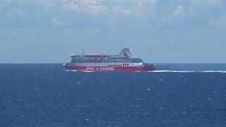
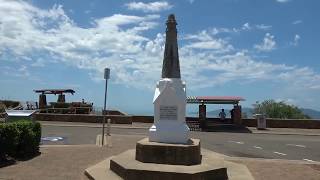
TASMANIA ROADTRIP DAY ONE Tasmania is an island state of Australia. On this road trip the plan was to roughly follow Highway One in Tasmania from Devonport to Hobart. The highway has a length of just over 300 km and is an inland route. Sail on the Spirit of Tasmania Since 2022 All Victorian Bass Strait sailings depart or arrive in Geelong. Corio Quay Road, North Geelong. One hour driving distance from the Melbourne CBD. I booked a day crossing on the Spirit of Tasmania. Also booked a cabin. Port to port from Victoria across Bass Strait takes nine to eleven hours. I was concerned if bad weather would affect the crossing and the movement of on ship vehicles. Cars are parked close together on the ship. The crossing of Bass Strait was all calm seas. So, no problems. Easy on/off in the Mustang GT. 1400 passengers and 500 vehicles can be carried. There is plenty of comfortable seating. Cooked meals are available to passengers. Devonport is the Spirit of Tasmania disembarkation point in Tasmania. Situated at the mouth of the Mersey River. Devonport has a resident population over twenty-three thousand. Located at Bluff Lookout in Devonport is the controversial Spirit of The Sea. The sculpture is a five metre tall, 700 kg bronze naked statue of Neptune holding a trident in his hands standing on a concrete plinth. The general public use the location as a picnic area with scenic sea views. Ross is a historic town in the Midlands of Tasmania. The town is 78 km south of Launceston and 117 km north of Hobart. Ross is a very scenic historic town alongside the Macquarie River. Built by convict labour in the early 1800s. The Ross Macquarie River Bridge is the third oldest still in use in Australia. There are 186 carvings by convict stonemasons on the Ross Bridge. Old elm trees line the main street. A field gun from the Boer War stands in the intersection of the main street. Port Arthur is a town and former convict settlement on the Tasman Peninsula, in Tasmania. Approximately one hundred kilometres southeast of Hobart. I booked a three hour wilderness cruise along the spectacular coastline between Eaglehawk Neck and Port Arthur with Tasman Island Cruises . Using custom built 43 seat capacity boats. The cruise follows along cliffs rising for hundreds of feet along the coastline observing sea life. Normally the sea is choppy but this time glassy calm. Calm only a few times per year. Port Arthur historic convict site is the end point for the cruise. Traveldriven GOOGLE MAPS SPIRIT OF TASMANIA GEELONG TERMINAL https://www.google.com/maps/place/Spirit+of+Tasmania,+Geelong+Terminal/ DEVONPORT https://www.google.com/maps/place/Devonport+TAS+7310/ ROSS https://www.google.com/maps/place /Ross+TAS PORT ARTHUR https://www.google.com/maps /search/PORT+ARTHUR CURRENT DEVONPORT FIVE DAY FORECAST DRIVE DEVONPORT TO PORT ARTHUR SPIRIT OF TASMANIA CROSSING BASS STRAIGHT Smoke Stack Spirit of Tasmania Spirit of Tasmania Arrival Devonport Spirit of the Sea 700 kg bronze statue Devonport DEVONPORT MALL THE 'JULIE BURGESS' TALL SHIP, DEVONPORT Spiky Bridge Built 1843 DRIVING TO HOBART SPIKY BRIDGE SPIKY BRIDGE BESIDE HIGHWAY TO HOBART UNDER ROSS BRIDGE ROSS BRIDGE, ROSS HISTORIC ROSS BRIDGE ROSS TOWN CENTRE ROSS TASMANIA PORT ARTHUR CONVICTS PORT ARTHUR BOATS Port Arthur church ISLE OF THE DEAD PORT ARTHUR THE FOX AND HOUNDS HOTEL ON THE ROAD TO PORT ARTHUR SEALS OFF OF PORT ARTHUR BASKING SEALS, TASMAN ISLAND TOUR TASMAN ISLAND CRUISE TOUR ENDPOINT IS IN PORT ARTHUR TASMAN ISLAND TOUR & CRUISE ALONG COAST PREV PAGE NEXT HOMEPAGE POST
- HAMILTON ISLAND & HOW TO SAIL SOLO ON THE GREAT BARRIER REEF
Hamilton Island The Great Barrier Reef The island is a tourist mecca of the Whitsunday Islands Group in Queensland, Australia. There are all types of accommodations and tourist activities. Located approximately 887 kilometres (551 mi) north of Brisbane. Hamilton Island Airport is serviced by commercial domestic flights from all over Australia. High rise units are some of the many accommodations available. There is an 18-hole golf course on neighbouring Dent Island. Daydream Island is serviced daily by ferry and is 18 km distant. From Hamilton Island boat cruises depart for the famous white sands of Whitehaven Beach on a high speed catamaran. The beach only thirty minutes away. Most people on Hamilton Island use golf buggies as a means of getting about. Regular public bus services run on the island. Watersports sailing and equipment hire on Hamilton Island's Catseye Beach are within quick walking distance from the islands high rise accommodation. Sailing catamarans are available for hourly hire from Catseye Beach. Prior little experience is required. All must stay within the confines of Catseye Bay. Hire a Sailboat on Catseye Bay I wanted to try a little sailing. Others did not want to join in, so I hired a Hobie Getaway catamaran for a solo sail of a few hours. Hire catamarans were lined up along the sand of Catseye Beach. The hire person said any prior sailing experience would be useful. Or perhaps not to go solo. Some time ago I was told, but not shown, how to manoeuvre a small sailboat and I had gleaned sailing basics online without being on water. I said beginner sailing experience. The hire person, a girl no older than twenty in a brief bikini, instructed don't leave the confines of Catseye Bay as the offshore currents will overcome the sailing capacity of the cat and it will be pushed dozens of kilometres away further along The Great Barrier Reef. Rescue of Sailors in Difficulty The young girls quote, 'I am watching the craft on the bay for any unlikely incidents, I will attend and assist if required' she explained. Her youthful appearance and casual manner did not give confidence. However, she must be competent to have the job. The Getaway sailboat has a full-batten mainsail, dual transom-hung rudders and no keel or dagger boards. A mast-top float and righting line to right the boat upon capsize. Five metres in length and a beam over two metres. Mast length of 7.6 metres. Both rudders are steered in tandem by the steering tiller. Stalled in Wind Catseye Bay is 1.7 km wide by 800 metres. With life jacket on, but no person to boat tether, I jibed to the left of the bay and stalled in slight gusting wind someway off of the beach. My mainsail was fluttering with no steering effect and the Getaway sailboat began slowly drifting towards a shoreline of rocks. I was unable to steer the cat about. Maybe assistance is already needed. The thought of rescue by an attractive woman in a bikini very pleasant but embarrassing. However, ten minutes of a few failed tacking attempts and the cat turned around. Wind billowing the sail. Solo Sailing Fun The cat took off like a rocket across the bay. I tacked starboard towards land and shot 1.5 km on return, further out this time. Slowed, using the tiller and tacked back again. I am watching movement of waves for the gusting wind and the direction of the thin telltales sailcloth high on the cat's main sail. Luckily, I did not capsize in these first few attempts while learning to handle tacking the catamaran to turn about as a solo sailor. Upon tacking moving body weight from port to starboard and back was essential to avoid tipping right over. I felt if parted away from the cat for any reason the speed was such, attempting to catch and reboard the cat would be next to impossible. It was a thrilling experience as the breeze freshened. I jibed and tacked many times lifting the hull clear of the water on occasion. Gaining more confidence on each jibe and tack. Not wanting to push the limits too far in case of a capsize I enjoyed sailing solo for several hours. It was great fun skimming the water in Catseye Bay. Better than I expected. Alas, no need for a rescue. Traveldriven ENTER CLICK/TAP HAMILTON ISLAND GOOGLE MAPS ISLAND SUNSET SAILING HIRE ON CATSEYE BAY HAMILTON ISLAND HIGHRISE VIEW FROM CATSEYE BAY SAILING A GETAWAY SAILBOAT IN STRONG WIND PREV BARRIER REEF NEXT PREV QUEENSLAND NEXT HOMEPAGE POST
- PLAN A DAY VISIT TO ARTHURS SEAT & ROCKING GONDOLA
Arthurs Seat Arthur's Seat stands 314 metres above sea level. The winding road leading to the summit is fully sealed. The road features several hairpin bends with a speed limit of 15 km per hour, which are best navigated in first gear if driving a manual. The tight bends and rising elevation is not as challenging as it might first appear. The road is in excellent condition as of 2025. There is a Summit Café with plenty of seating and food options. The endpoint and lookout of the Arthurs Seat Gondola are located in the same area. The operators will shut down the gondola if high winds arise. No Gondola passengers are left stranded on the top if there is a closure. Gondola operators' return riders by road vehicle to the lower admission entry if the need arises. There are views of Port Phillip Bay through the tops of the surrounding bushland trees from Arthurs Seat summit. Although the views are generally obscured by trees. Arthurs Seat is thirty minutes drive from the seaside town of Sorrento and the car carrying ferry that crosses the bay to Queenscliff. Most of the coastal road is busy in the summer months. The drive is partly driven on freeway and it is a seventy-minute drive from Melbourne CBD on this side of the bay. Arthurs Seat is in a built-up area as is much of the coastal Mornington Peninsula of Victoria. Hot and High Winds Forecast On this visit the daily forecast was predicting a temperature of 37°C and high winds. This led to the necessary precaution of closing the Gondola for safety reasons. It is advisable to plan a trip to ride the Gondola on a day with a forecast of low winds to ensure a smooth and enjoyable experience. Despite the closure, the day still offered a pleasant drive with scenic views. A notable feature near the café is a cast statue depicting a larger-than-life eagle, adding a touch of artistry to the surroundings. Additionally, visitors can find an oversize outdoor chair named Arthurs Seat, inviting them to take a seat and enjoy a moment of relaxation. This harmless and fun activity resembles an all-weather throne, creating a whimsical and intriguing sight for visitors to appreciate. Traveldriven ARTHURS SEAT GOOGLE MAPS SORRENTO GOOGLE MAPS DRIVE ARTHURS SEAT LOOKOUT EAGLE & ARTHURS SEAT EAGLE ROCK HIGH WINDS CLOSURE BAYSIDE FISH & CHIPS SORRENTO UNDER THE PINES PREV VICTORIA NEXT HOMEPAGE
- DO YOUR TRACK TIME ON THE BEND MOTORSPORT PARK
Pit Lane Getaway High Speed Track Time in Your Own Vehicle This is a motorsport package. The on-track driving experience was undertaken in December 2025. A waiver form must be signed before driving on track. One passenger is allowed. The package includes thirty minutes of a track cruise, dining and an overnight stay. Includes a limited dinner menu, onsite overnight motel accommodation and a full breakfast for a total of $299. The onsite free to inspect Auto Gallery features a variety of both vintage and modern cars, including vehicles designed for both racetrack use (including F1) and road use. The selection of vehicles is periodically updated. Other packages may include: Breakfast & Bends. (subject to availability) Thirty minutes on track time plus breakfast $39. Lunch & Laps. (subject to availability) Thirty minutes on track time plus lunch $49. THE BEND MOTORSPORT PARK SOUTH AUSTRALIA Essentially, the Pit Lane Getaway is a high-speed drive on the Motorsport racetrack before dinner. Briefing is at 5 pm. Followed by thirty minutes on track time. Dinner is 6 pm served at the Apex Bar & Dining. Afterwards enjoy Rydges trackside overnight accommodation followed by a morning breakfast in the Apex Bar. Owners drive their own road going vehicle. Traveldriven drove a Mustang GT V8 6 speed manual. On this occasion peak speed was about 170 kph. Twenty-eight km was driven on track for 23 Litre's per 100 kilometres (ten m iles p er g allon US). As a reference average Mustang highway driving mileage is 8.7 L per 100 km or 27 mpg (US). Fuel: 98 octane unleaded. Tyres: Pirelli P Zero In vehicle drive mode: Switched from normal to racetrack Eighteen vehicles on track and pace car leading the field. Breakfast & Bends and Lunch & Bends Previous experiences at the Bend Motorsport Park. On track participants awoke early for a thirty-minute session on the racetrack. This track time was allotted before breakfast. Afterwards all drivers attended breakfast served in the Apex Bar. The morning racetrack session was more enjoyable than the afternoon session with more cars on track for the afternoon. Each session was preceded with a compulsory driver briefing. This included track layout, safety and regulations briefing. On this particular day track conditions were ideal. No drivers were allowed to overtake the pace car. There were a few front brake lockups by other drivers. These lockups causing momentary tyre smoke. Mustang GT track grip was excellent. Trackside marshals were in attendance at strategic track locations. Early Start Waking up early to start the day with a thirty-minute session on the racetrack is a testament to dedication and passion for the sport. The crisp morning air sets the scene for a focused and invigorating experience. The track slowly comes to life, with the hum of engines and the screech of tyres cutting through the quietness of the morning hour. Each lap around the racetrack is a symphony of precision and skill, with every turn and straightaway presenting a new challenge to conquer. The adrenaline rush of pushing the limits, feeling the slight G-forces in every corner, and striving for the perfect racing line creates a sense of exhilaration that is unmatched. The concentration required to navigate the twists and turns at high speeds demands complete focus and control, honing both physical and mental agility. In those thirty minutes on the racetrack, there is a unique sense of freedom and liberation that comes from pushing oneself to the edge of performance. It is a time to escape from the demands of everyday life and immerse oneself in the pure joy of speed and competition. The camaraderie among fellow drivers, the shared passion for the sport, and the mutual respect for each other's skills all add to the sense of community and belonging that the racetrack provides. As the session draws to a close, the sun rises higher in the sky, casting a golden glow over the track and signalling the end of another exhilarating morning or afternoon on the racetrack. The memories of those two thirty-minute sessions pushing the car and oneself will linger, fuelling the anticipation for the next opportunity to hit the track and chase that adrenaline rush once again. Mustang GT & Highest Speed Mustang exceptional track handling was commented on by fellow drivers. Highest speed obtained was greater than 170 km/h (105 mph plus) with more in reserve. At least 180 km/h felt attainable following behind the pace car on pit straight. No track incidents occurred. No off track over enthusiastic driving errors for any of the participates. A great day of fun and a new experience. Traveldriven THE BEND MOTORSPORT PARK TAILEM BEND GOOGLE MAPS OLD BITUMEN SURFACE OF TURN 23 LIMITED EDITION SOUVENIR ONE LAP OF GT CIRCUIT, 35 TURNS THREE RACETRACK READY MUSTANGS THE BEND MOTORSPORT PARK 2025 AUTO GALLERY FERRARI BLACK FERRARI, AUTO GALLERY AUTO GALLERY RACING CAR DRIVER BRIEFING BEND RACETRACK DRIVING THE BEND RACETRACK DECEMBER 2025 Prior to 2025 PARKED WITH VALID PERMIT MUSTANGS READY FOR ON TRACK TIME DRIVER BRIEFING BEFORE TRACK TIME EARLY MORNING SESSION ON TRACK THE BEND RACETRACK THE BEND DRIVER EXPERIENCE LANDROVER ON A POLE. KEITH, DUKES HIGHWAY 130 KM FROM THE BEND MOTORSPORT PARK. PREV MUSTANG GT NEXT PREV SOUTH AUSTRALIA NEXT
- NULLARBOR CLIFF HANGER Big Righthand Turn South Australia
DAY 2 'Stopped and checked for carriage into Western Australia by quarantine inspectors. Car boot thoroughly searched' - Traveldriven Nullarbor South Australia The Eyre Highway is the only east, west road passing through the Nullarbor Plain to Western Australia. Nullarbor Roadhouse is at the eastern boundary of the Nullarbor Plain and Border Village is at the western boundary of the Nullarbor Plain. These two roadhouses provide services for tourists and travellers such as accommodation and vehicle fuel. Nullarbor Roadhouse In the middle of nowhere. Nevertheless, it's somewhere to stay overnight. There are motel units or caravan sites. Food and fuel. Nullarbor means no trees. Over 100,000 wild camels roam the plain. The longest stretch of straight road in the world may be driven near here. A distance of 146.6 km along the Eyre Highway outside Balladonia Roadhouse. Newspaper stories on a notice board describe the legend of the Nullarbor Nymph, a half-naked feral woman, once thought to have roamed the plain among the kangaroos in the 1970s. Made headlines worldwide. A historic scale model of the old station/garage is next door to the roadhouse on display. Border Village The area consists of little more than the roadhouse. Border Village Roadhouse is right before the Quarantine Checkpoint driving from South Australia. The Roadhouse is the home of the giant kangaroo. One of Australia's Big Things. There are a few motel units and caravan sites. The roadhouse has a shop, fuel and a restaurant/bar with cold beer on tap. A Quarantine Checkpoint is inside the Western Australian border. Risk items include fresh fruit, vegetables, some nuts, seeds as well as honey. I was stopped and checked for carriage into Western Australia by quarantine inspectors. Car boot thoroughly searched. Road checkpoints operate 24 hours. Eucla One of the most memorable driving experiences I recall is the first solo road trip driving to Western Australia. One odd event occurred during a service station stop on the Eyre Highway. In the small township of Eucla near the border with South Australia and Western Australia. While filling the car with petrol, a Holden sedan pulled off the highway and parked next to a fuel bowser. The driver filled his car, paid and rejoined the highway. Normal enough. But his sedan was minus all four doors, bonnet and the rear window. The car did have number plates. A funny sight in the middle of nowhere. In this Outback and desert country. I assume the driver and car drove from an Outback station homestead to refill with petrol and returned back to the station. All other vehicles along this highway were packed full of long-distance travel supplies etc. Mostly towed caravans and trucks. So out of place and questionable if road legal. I think it had seat belts and side mirrors . Eucla is on the Western Australian side of the SA\WA border. Population of roughly fifty residents. Just the one motel or limited caravan sites are available. There is nowhere else to stay overnight. Eucla Telegraph ruins are well worth a look. The Telegraph commenced operations in 1877 and linked Western Australia with the rest of the world sending over 20,000 messages a year until 1927. The ruins are often half buried in drifting sand dunes. These ruins are accessible via a short unsealed two-wheel drive road. After Eucla was founded and sometime there afterwards the current townsite was established about 4 km higher up. The Eucla area is the only location on the Eyre Highway off the Eucla Pass with a direct view of the Great Australian Bight cliffs due to its elevated position. Occasionally whales can be seen. One of Traveldriven's top eight Australian lookouts. For another top eight please go to. The Living Desert Broken Hill NSW Post ENTER CLICK/TAP EUCLA GOOGLE MAPS CURRENT NULLARBOR FIVE DAY FORECAST DRIVE NULLARBOR ROADHOUSE - BORDER VILLAGE - EUCLA HISTORIC SERVICE STATION DISPLAY EYRE HIGHWAY THE ONLY EAST/WEST HIGHWAY ROOEYII BORDER VILLAGE SOUTH AUSTRALIA NULLARBOR CLIFFS & SOUTHERN OCEAN Molly's Nullarbor roadtrip. Drone views of the Great Australian Bight and cliffs. Great footage of the area 6.25 minutes into the video. Personally think the Eucla cliff views are the best from the handful of Nullarbor highway turnoffs. These are accessible to any highway travelling vehicles. Thanks in advance to Molly Dixon Youtube channel for enabling sharing of Youtube video's. Traveldriven THE NULLARBOR NULLARBOR CLIFFS SIGN ON ROADHOUSE 'NULLARBOR NYMPH' EUCLA TELEGRAPH RUINS RUINS ARE 2WD ACCESSIBLE ALONG SHORT UNSEALED ROAD TO THE CLIFFS AREA EUCLA WHALE CAR BOOT SEARCH BORDER CHECK DON'T GET TO CLOSE TO THE UNSTABLE CLIFFS PREV SA/WA/NT NEXT PREV SOUTH AUSTRALIA NEXT HOMEPAGE
- CASTLE HILL LOOKOUT & ROCKPOOL SWIM ROAD TRIP AUSTRALIA
TOWNSVILLE ROAD TRIP AUSTRALIA For myself, Townsville is the road trip destination. 2,800 km from Victoria and home. I approached Townsville driving from inland Queensland and connected with the coastal Bruce Highway. The highway continues through Townsville and onto Cairns or down the coast south to Brisbane. The first task was to drive up Castle Hill. Here there are great views of the city and Magnetic Island. I reserved a relaxed three-hour jetski tour of Magnetic Island for a few days from now. The owner of the jetski hire conducting the tour. Both he and I on our skis circumnavigating the island in a leisurely fashion with a few stops here and there. When just offshore on the jetski large turtles may be spotted swimming in the clear waters surrounding Magnetic Island. Prominent island features are pointed out on the jetski tour. Very informative. If time allows walk through island bushland on a clearly marked trail to the abandoned World War Two forts. The Strand While in Townsville visit and relax along "The Strand". This is a two km watered foreshore promenade available to the public. There are shady palm trees, green grass, eateries, and water parks etc along this thriving beach foreshore of Townsville. Located back behind the beach The Strand may be driven along its length. On this trip, convenient accommodation was in Rydges Motel in Palmer Street. The motel a short drive away from the foreshore and central city. Palmer Street has the outdoor cafés, hotels and restaurants to enjoy. Tourist souvenirs may be purchased along Palmer Street in one of the retail shops. The Strand Rockpool Enjoy a free swim in the sea water rockpool on the Strand. This is a saltwater lagoon. The large rockpool is fully enclosed and separated from the open sea. There is a shallow area and a deeper area for swimming. There are clear views to Magnetic Island across the water. The rockpool is usually attended by a lifeguard and is open most days. Provided and maintained by local government. Castle Hill Is a granite monolith in the suburb of Castle Hill, Townsville. Castle Hill stands at a height of 286 metres (938 ft) above sea level. A well-made sealed road leads to the top. Views are to the city skyline. Elevated views are of Magnetic Island that is some four km distant. Castle Hill Lookout is one of Traveldriven's top eight Australian lookouts. For another top eight pick please go to: Mount Wellington Tasmania Post Traveldriven CURRENT TOWNSVILLE FIVE DAY FORECAST ROAD TRIP AUSTRALIA ENTER CLICK/TAP TOWNSVILLE GOOGLE MAPS MAP OF CASTLE HILL ROAD CASTLE HILL & LOOKOUT Castle Hill Townsville from Castle Hill Castle Hill descent Castle Hill backdrop Castle Hill driving Two the same Townsville CBD Townsville artwork The Rockpool Along the Strand TOWNSVILLE QUEENSLAND GOOGLE MAPS PREV ROADTRIP TOWNSVILLE NEXT PREV QUEENSLAND NEXT HOMEPAGE
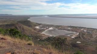
- FIVE RIVERS LOOKOUT, & CROC SAFE. WYNDHAM WESTERN AUSTRALIA
FIVE RIVERS LOOKOUT, WYNDHAM The drive from Wyndham to Five Rivers Lookout takes you to the top of one of the best views the Kimberley has to offer. The lookout stands 335m above sea level giving an excellent panoramic view. It is easy to find just by following the signs from Wyndham town centre and the sealed steep winding road will lead to the summit lookout. Suitable for both 4wd and 2wd vehicles. Not towed vans. Once on top stunning views will become apparent of the multiple rivers all around! There is plenty of parking and a covered picnic area with tables are available for tourists. The occasional roadtrain may be observed far below travelling to and fro from the Port on the dusty roads. From the top of the Gulf Bastion is where the following five rivers of the Gulf meet: Durack Kink Pentecost Forrest Ord Five Rivers Lookout is a crocodile safe area that provides visitors with a unique opportunity to enjoy the stunning natural beauty of the region without the looming threat of fatal crocodile attacks. This lookout offers a safe vantage point to admire the picturesque landscape, including the convergence of five rivers, while ensuring the safety and peace of mind of those who visit. In contrast to the safety of Five Rivers Lookout, the area around Wyndham has unfortunately witnessed tragic incidents of fatal crocodile attacks in its waterways and surrounding areas. These attacks serve as a stark reminder of the potential dangers posed by these apex predators in certain environments. Visitors to Wyndham are advised to exercise caution and adhere to safety guidelines to mitigate the risks associated with crocodile encounters. Underscoring the risks present in the vicinity of Wyndham, it becomes evident that being informed and vigilant when exploring natural habitats is crucial. The coexistence of humans and crocodiles in these regions underscores the importance of respecting wildlife and understanding the need for responsible behaviour to ensure the well-being of both visitors and the native fauna. Five Rivers Lookout is one of Traveldriven's top eight lookout picks of Australia. For one of the other top eight please go to: Castle Hill Lookout Queensland Post Traveldriven ENTER CLICK/TAP WYNDHAM GOOGLE MAPS VIEW FROM FIVE RIVERS LOOKOUT FIVE RIVERS LOOKOUT CAMBRIDGE GULF VIEW FIVE RIVERS LOOKOUT WYNDHAM PORT AREA WYNDHAM, GOOGLE MAPS PREV WESTERN AUSTRALIA NEXT HOMEPAGE
- THE REAL GALWAY GIRL EMMA O'SULLIVAN
Galway In the West of Ireland, nestled within the picturesque landscapes of County Galway, lies the vibrant city of Galway. This charming city is easily accessible by car, and the drive through the lush Irish countryside is very scenic. With a population of approximately eighty thousand residents, Galway is a lively hub of culture, history, and community spirit. The city centre of Galway is characterised by its bright and colourful shopfronts that line the winding streets, creating an inviting atmosphere for both locals and visitors alike. The layout of the streets may remind one of a micro–Royal Mile, akin to that of Edinburgh Scotland, with its charming nooks and crannies waiting to be explored. As the warmer months arrive, the city comes alive making it a perfect time for leisurely strolls through the bustling streets. Street Performer Emma O'Sullivan, of Galway During this season, one can often encounter a variety of street performers showcasing their talents, adding to the vibrant ambiance of the city. Among these performers, one individual stands out and has garnered a significant following: Galway's Emma O'Sullivan, who is an accomplished Irish dancer known for her captivating performances. On one particular day, as I wandered through the lively streets of Galway, I was drawn to the sound of lively accordion music that filled the air, accompanied by the rhythmic tapping of Emma's feet on the cobblestones. Her energy and skill attracted a large crowd, captivated by her artistry and the infectious joy that radiated from her performance. Emma O'Sullivan is not just a local talent; she is a well-known figure in the world of Irish dance, with many videos of her street performances circulating on platforms like YouTube. One such video, posted by the channel Traveldriven, captured a spontaneous performance during a chance encounter with Emma in the streets of Galway. This particular video quickly gained traction, going viral and amassing well over a million views, much to the surprise of its creator. Initially, the video was described as featuring tap dancing; however, it was soon pointed out that Irish dancing is a distinct and separate art form. Acknowledging this oversight, Traveldriven promptly updated the video description to reflect the accurate terminology. Reflecting on that memorable day, there are feelings of a twinge of guilt for not leaving a tip in the donation bag that accompanied her performance. It is a common practice to support street performers who share their talents with the public, and witnessing Emma's vibrant display of Irish culture and professional dance was a moment of appreciation for all visitors to witness on the day as she performed in the streets of Galway. Traveldriven GALWAY https://www.google.com/maps/ place/Galway,+Ireland Emma O'Sullivan Irish dancing Greater than one million views on Youtube DRIVING AROUND THE COUNTRYSIDE WHAT A RELIEF! ROSS CASTLE SIGNAGE ROSS CASTLE HOTEL ROOM VIEW QUEEN VICTORIA SAID ONLY FIT FOR A LADY ONLY IN IRELAND MURPHY'S PUB, MURPHY'S LAW MAD HATTERS OF DINGLE IRISH FLOWER BOAT STORM IN A TEA CUP STORE IRISH COAST GUARD PREV PAGE NEXT HOMEPAGE
- DRIVING THE WIMMERA MALLEE SILO ART TRAIL VICTORIA
When tourists try small town name pronunciations sometimes it sounds quite comical -Traveldriven DRIVE MELBOURNE TO RUPANYUP Rupanyup & Driving the Wimmera Mallee Silo Art Trail Victoria Rupanyup is a small town in Victoria. The town is home to approximately five hundred residents. The Silo Art Trail passes through this town, which also features several intriguing rustic-style statues. One is of a man patting his trusty dog next to a small seat. This statue is outside of the modern local supermarket. Another is of a woman in period costume outside of an early period store in the centre divider of the main street. As in many rural towns, Rupanyup has its fair share of closed retail buildings. The name Rupanyup is an Aboriginal word meaning ' branch hanging over water '. Minyip It is a small town located in the Wimmera region of Victoria, situated along the Silo Art Trail, approximately 320 kilometres northwest of Melbourne, with a population of around five hundred. The name "Minyip" is an Aboriginal word translated as "ashes" or "camping place". Minyip is known as the "Heart of the Wheat Belt". Warracknabeal This is a wheatbelt town in Victoria. On the banks of the Yarriambiack Creek. The Warracknabeal area has a population of less than three thousand. On the main street, there's a roundabout named Federation Place, featuring a group of six life-sized sheep statues on an elevated brick platform. Another roundabout displays a sheepdog atop stacked, full wheat bags. There are two double storey hotels in town. Both have wide covered verandas and counter meals may be ordered. The town has a few red brick period buildings. Post Office and a Town Hall. When tourists attempt to pronounce the names of small towns, it can often sound quite amusing. However, when a local says the name aloud, the pronunciation comes naturally to all. The drive from Rupanyup to Minyip and then to Warracknabeal covers eighty kilometres of sealed roads. There is a lot to see driving the Wimmera Mallee Silo Art Trail. Traveldriven WARRACKNABEAL GOOGLE MAPS OUTSIDE THE NEW SMALL LOCAL SUPERMARKET Life size statue and display store Rupanyup's main street RUPANYUP SUPPORT LOCAL COMMUNITIES BUY A COFFEE Closed shops in central Rupanyup RUPANYUP SILO ART DRIVING THE WIMMERA WHEAT BELT SHEEP HILLS SILO ART DRIVING SHEEP HILLS & WARRACKNABEAL PREV VICTORIA NEXT HOMEPAGE
- BALLARAT SPRINGFEST 2025\23 & 2019 SHOW 'n' GLOW
Ballarat Ballarat expanded into a large regional city from when gold was discovered in 1851. Located in the Central Highlands of Victoria, one hundred and fifteen km from Melbourne CBD via the Western Freeway. The city has a population of greater than one hundred thousand residents. In terms of population Ballarat is the third largest inland city in Australia. Often said to be one of the coldest cities in Australia. Lake Wendouree is a man made almost circular shaped lake of about two km across. The lake is located within the Ballarat city area and is a popular recreation area. Ballarat Springfest The Ballarat Springfest festival held in late 2025 celebrated its 30th anniversary. The festival is located at the Gardens Precinct, Lake Wendouree. Held on a Sunday, there are up to five hundred market stalls to explore, offering goods, food, and various other items for sale. A large vintage and classic car show called Show 'n' Glow is featured in the morning as a part of Springfest. Ballarat Attractions Apart from Springfest Show 'n' Glow Sovereign Hill Located within Ballarat city this is an open-air tourist park based around the gold era of the 1800s. Over sixty historically correct buildings with themed costumed employees. Officially opened in 1970. Eureka Stockade Memorial Park The Stockade is off of Eureka Street. Accepted as the site of the miners rebellion of 1884 against the British authoritarian rule and their soldiers. The Eureka Stockade Monument has four 64-pounder large cannons arranged in a circular pattern in parkland. Kryal Castle A themed medieval castle built off of the Western Freeway twelve km from Ballarat towards Melbourne. There are small medieval themed retail and family friendly amusements. Traveldriven BALLARAT GOOGLE MAPS SOVEREIGN HILL KRYAL CASTLE EUREKA STOCKADE MEMORIAL PARK 2025 SPRINGFEST SHOW & GLOW IS IT A TRUCK OR BUS? BUS\TRUCK WITH ITS RESERVE GAS SUPPLY FANCY INTERIOR THE LAST DRIVE HOT ROD & TEARDROP AUSTRALIAN PARCEL EXPRESS? COLORFUL WAGON WAGON ENTRY LOW REAR END & GOING HOME ALL FIRED UP & READY TO GO BALLARAT SHOW & GLOW NOVEMBER 2023 Many hot rods on the green grass Threat of rain and Ford hot rods Many immaculate cars Many supercharged Mustang Shelby official performance report from GM Motorsport in Melton, Victoria Mustang Shelby super snake in the long grass. BALLARAT SPRINGFEST SHOW & GLOW 2023 BALLARAT SPRINGFEST 2019 SHOW & SHINE 2019 Nice flaming paintwork. Open top. Fuel container on front or is it water? Vivid black and red. Front opening windscreen All bright red. Long body. Lowered Spotless interior. Left hand drive. Large matching colour steering wheel Left hand drive. Interior radio. Budweiser gear knob VB gear selector knob. High side mirrors Open wheeler road car DeLorean Back to the Future movie car. Road legal DeLorean time machine. Delorean made in 1981. Gull wing doors. Back to the past 1981 Hot rods on the green grass Two hot rods under a shady tree on firmer ground Overnight rain softened the ground Large fish fins on rear. Left hand drive Bright yellow. Two antennae on rear PREV SHOW & SHINE NEXT PREV VICTORIA NEXT HOMEPAGE